
 २२.१२°C काठमाडौं
We use Google Cloud Translation Services. Google requires we provide the following disclaimer relating to use of this service:
This service may contain translations powered by Google. Google disclaims all warranties related to the translations, expressed or implied, including any warranties of accuracy, reliability, and any implied warranties of merchantability, fitness for a particular purpose, and noninfringement.

Highlights
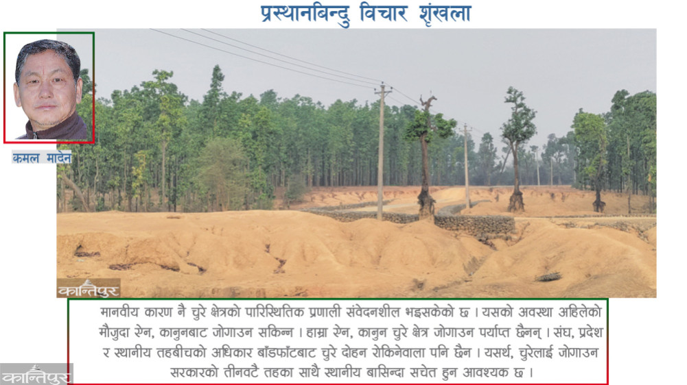
- Our laws and laws are not enough to protect the stolen region. Moreover, the distribution of powers between the union, state and local levels is not going to stop the exploitation of the stolen goods. Therefore, all three levels of government and local residents need to be aware to protect Chure.


Childhood spent near Chure area. At that time it was not known that the hill connected to Sunsari's Dharan was called Chure. We used to call it Sanguri Danda, and it is still a distinct name. While studying at university, I came to know that Chure area is also called Sibalik. Chure is also called Mahabharata mountain by some people. It is not the Mahabharata mountain.

Another thing is that Sanguri hills do not fall in Chure area. A few years ago, while reading some pages of the book Himalaya by David Jurick and PP Karan (year 1999), Meghraj Dhital's 'Geology of Nepal Himalaya' (year 2015), Mike Searle's 'Colliding Continents' (year 2017), Bikram Shrestha's Origin of the Himalayas (year 2022). Very informative.


A friend of mine is studying wildlife in Chitwan. To see if he, like me, had doubts about the Chure area, I asked him whether the place he worked at was Chure or not. He immediately said, "It is not a mountain right in front of the Terai, it is much higher, so it is not in the Chure area, but in Sibalik." While most of Chitwan falls under Chure region. Chitwan is the district with the highest number of broken areas in Nepal. Mitra may not have stolen the geography where he is working, but he also said that it belongs to Sibalik. While Chure and Sibalik refer to the same region. Indians call Chure Sibalik. Sibalik is also written in Nepal. Chure is called 'Foot Hills', 'Outer Himalayas, Sub-Himalayas' in English terminology. I have been interested for many years to know who wrote Chure as Sibalik in India, why and when. During this process, I also asked the geology and geological science scholars, they were also excited to get information that they did not know.
Sibalik word
Only a few months ago it became known that PT Cowtle and H Falconer of the East India Company were the first to describe the Sub-Himalayas as Sibalik. Coutley was an engineer and archaeologist for the East India Company. He conceived the idea of making a canal through the Ganges in India and supervised its commencement. The canal was started near Haridwar in Uttar Pradesh. During the construction of the canal, fossils of especially extinct animals were found in abundance in the sub-Himalayan region. All these fossils were described by Paleontologist and paleontologist Falconer of the India Company. Falconer also classified and named fossils with scientific description.


In this way, Coutley and Falconer jointly published the details of the extinct elephants, rhinos, water rhinos, crocodiles, gharials, zebras, etc. in the sub-Himalayan region of Uttar Pradesh, but they did not know what the Indians call the fossil collection area. Until then, there was no information and study about how and when the entire Himalayan region, including the sub-Himalayan region, was formed. In 1912, German Alfred Wegener hypothesized that continents, oceans, and islands are moving. That hypothesis was transformed into the 'plate tectonic theory' in the 1960s. Earthquakes, volcanoes, mountains and mountain formations, oceanic trenches are formed due to the movement of "tectonic plates".
When the East India Company was in India, the British called the Chure area 'Sub-Himalayan Region' i.e. sub-Himalayan region. Coutley and Falconer are in contact with the Mahants living in Haridwar. Mahant says that the whole area was called Shivalaya at that time. In this context, the author has stated that the Sibalik area is the area where Lord Shiva resides from the Hindus and that area falls under the 'Sub-Himalayan Region'. This information was published in the 'Nineteenth Volume of Asiatic Researches' (year 1836). The East India Company established the Geological Survey of India in 1851. It worked on the mapping of the Sibalic region in India. Sibalik region extends from Pakistan's Potwar Plateau to Northeast India.
Chure origin
The magma inside the earth is moving in different directions due to its extreme heat. Furthermore, the hard rock beneath the Earth's surface is broken into different shapes as it rests on top of the hot magma. It is called 'tectonic plate'. While the magma is moving, the earth's surface above the 'tectonic plate' is moving very slowly in the direction of the magma flow. According to the 'Plates of Tectonic Theory', about 9-100 million years ago, the 'Tectonic Plate' of the Indian subcontinent was in the eastern and southern part of Africa. It drifted northward at a rate of a few inches per year. About 50 million years ago, when the Indian and Eurasian plates collided and collided, the magma beneath the Indian subcontinent slowly sank beneath the Tibetan Plateau.
The outer hard mantle of the Indian subcontinent continued to heat up through 'folding' or subduction. In this sequence, first the High Himalayas (High Himalayas), then the Mahabharata mountain range (Lesser Himalayas) were formed. Surprisingly, it is scientifically believed that the area where the Chure region is now is hollow and was filled with water. There were water-like creatures like crocodiles, gadiyals, water rhinoceros etc. Fossils of the creatures of that time have been found in abundance. Gradually, the section filled with water also came out a little higher.
One and a half to two million years ago, the high Himalayas and the Mahabharata mountain range were rising at a rapid pace. They began to rise rapidly. In this process, the stones, soil, sand, and gravel were moved towards the south and started piling up in the "Foot Hills" area. There, huge boulders that came down from the north crashed into each other and fell on top of each other. Runoff soil, gegrian, was added to it and piled upon pile to form a weak surface. As mentioned in the book titled 'Geology of Nepal Himalaya' (2015) written by Meghraj Dhitala, the stones, soil and Gegrian accumulated in the 'Foot Hills' of Karnali region of Nepal are the oldest. It was buried about 16 million years ago (page 385).
Looking down from the Mahabharata mountain range, the 'Foot Hills' look like Hocha mounds. However, peaks are visible from the plains. Therefore, the people living in the Terai began to call the 'Foot Hills' Chure Hill and the area around it as Chure Kshetra. Even in the Nepali dictionary, it is written that Chure is the Hocho hill that stretches to the north of the Terai and to the south of the inner Madhesh. Chure occupies 12.78 percent of the country's total land area in Nepal.
Districts including Chure area
There were earlier 20 districts in Nepal that were bordered to the south. When the Constitution of Nepal was promulgated, Nawalparasi district was divided into Bardghat East and West. Therefore, the number of districts bordering India to the south has reached 21. To the south of those 21 districts is Terai and to the north is Chure region. Out of the 17 districts bordering on the north of that district, except for Panchthar, Dhading, Gorkha and Rolpa, Chure area is spread in the rest.
Makwanpur is not a Terai district. According to the study report titled Churia "Forests of Nepal" (year 2014) published by the Department of Forest Research and Survey under the Ministry of Forests, the Churia area has spread to a small extent in Lalitpur and Kavre districts, which are connected to the east-north border of Makwanpur. Of the total area of those 2 districts, 1.49 percent and 0.53 percent of the area includes Chure, respectively. Similarly, Udaipur is also not a Terai district. Chure occupies 0.04 percent of the total area of Bhojpur district, which is its northeastern border. Thus, Chure area is spread over 37 districts in Nepal. There are 6 districts that occupy more than 50 percent of the districts. 84.25, 81.16, 57.79, 57.41 respectively in Chitwan, Dang, Sindhuli, Makwanpur, Nawalparasi and Udaipur districts. And 57.16 percent is Chure area. Among the districts bordering India to the south, Sunsari and Rautahat have the lowest poverty rates of only 8.7 and 9.61 percent. However, the highest is 44.15 percent in Kailali district. The
zone consists of loose sheet rock that is not fully excavated. Due to the rivers flowing from the high Himalayas and the Mahabharata mountain range flowing through them and the rivers originating in the Chure area but flowing in Barkha, the area is naturally very sensitive. The Government of Nepal launched the Presidential Chure Conservation Program in the financial year 2066/67 to mobilize Chure Conservation as a campaign. At the same time, the Government of Nepal is conducting the Chure Conservation Campaign on an institutional basis by issuing the "President Chure-Tarai Madhesh Conservation Development Committee (Formation) Order 2071" in accordance with Section 3 of the Development Committee Act 2013 on 2nd June 2071. At that time, the slogan was decided to be 'Stealing soil for those who steal, clean water for everyone'. Since then Chure Day has been celebrated on June 2. Similarly, an agreement was reached between the government of Nepal and the Food and Agriculture Organization of the United Nations in Nepal on 30th Baisakh 2077, and Chure Uplifting Project is being conducted to increase the upliftment of the Chure area in the eastern and central part of Nepal.
Chure region is the latest among the diverse geographical formations of Nepal. Due to the high population growth in the area where the upper surface is not well dug, deforestation has increased significantly. Due to the fact that sand and gravel are excavated from the river channels and sometimes exported to India, the ecological system there has become sensitive. Its situation cannot be saved by the current laws and regulations. Our laws and laws are not enough to protect the stolen region. Moreover, the distribution of powers between the union, state and local levels is not going to stop exploitation. Therefore, all three levels of government and local residents need to be alert to protect Chure.
 प्रकाशित : श्रावण ९, २०८१ ०८:४६


