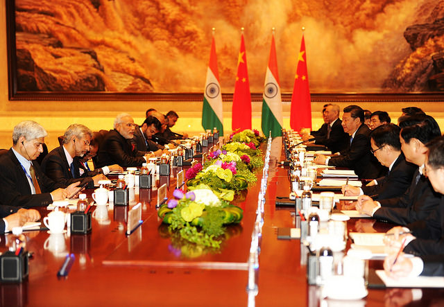
Even though Nepal remained neutral in the India-China war of 1962, Nepal was forced to pay the price for Kalapani, King Mahendra remained silent to facilitate power, China also supported India for commercial interests.
We use Google Cloud Translation Services. Google requires we provide the following disclaimer relating to use of this service:
This service may contain translations powered by Google. Google disclaims all warranties related to the translations, expressed or implied, including any warranties of accuracy, reliability, and any implied warranties of merchantability, fitness for a particular purpose, and noninfringement.
The neighbors to the north and south have tried to improve their relations, but have again shocked Nepal by agreeing to trade through the Lipulek Pass. China and India have not even informed Nepal when they agreed to trade through Nepalese land. These two neighbors have been playing with Nepal's sensitivities by bringing up this issue time and again for a decade
Since 1962, the Indian Army has been occupying the Nepalese land Kalapani since this issue has been bothering Nepal. Kantipur has prepared this 'Explainer' to recall the overall context of this 63-year-long ups and downs, the geographical location and strategic importance of Kalapani and Limpiyadhura, the historical background and series of disputes, India's seizure of force by China, and Nepal's response. In which 7 questions are answered .
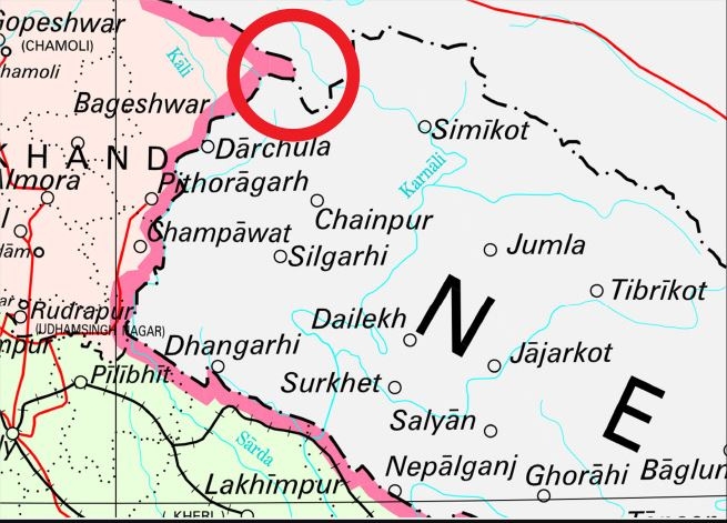
Where is Kalapani, Lipulek and Limpiyadhura?
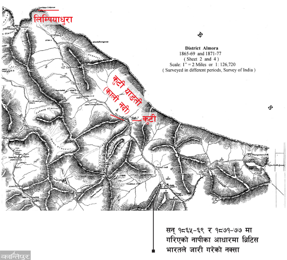
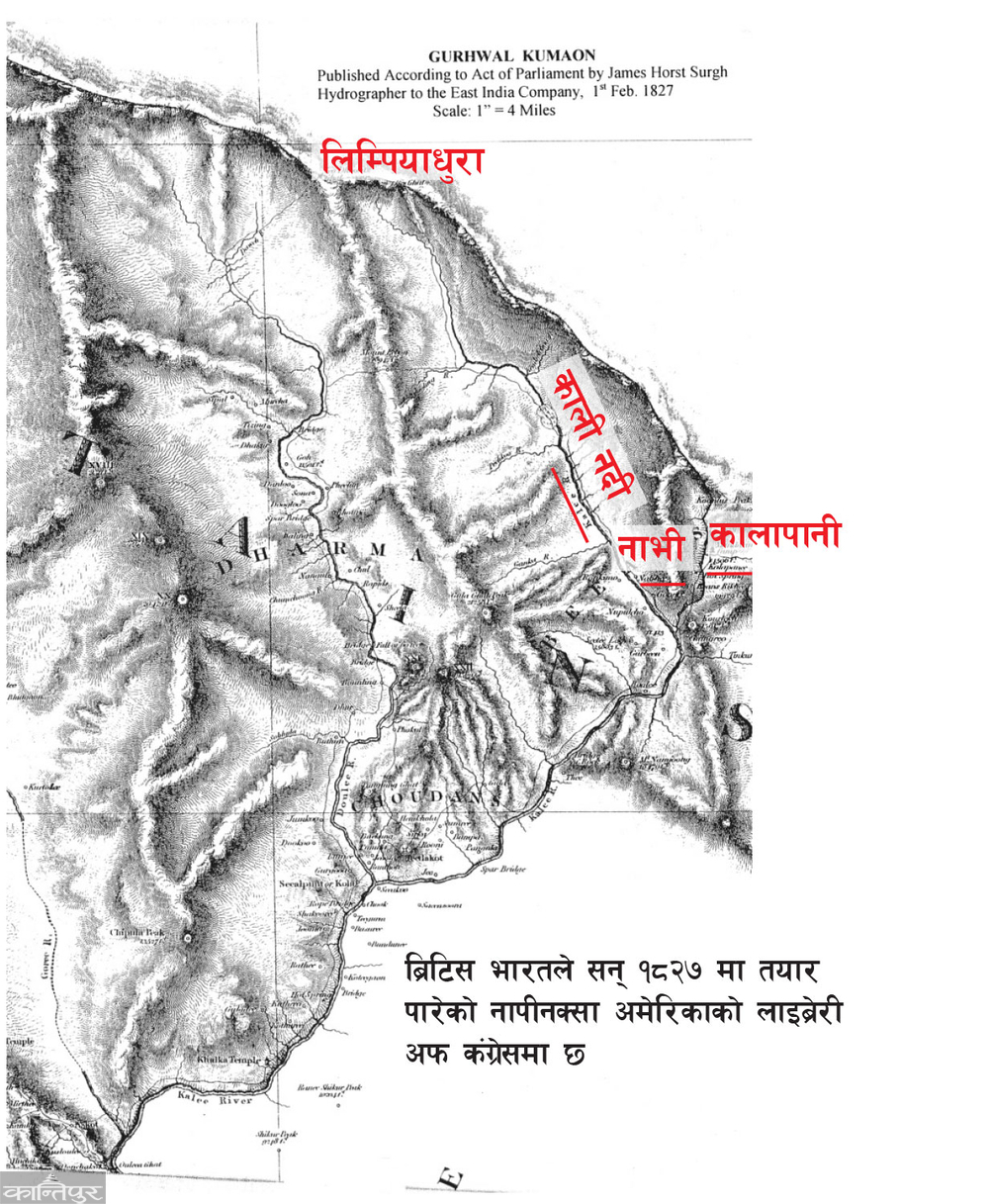
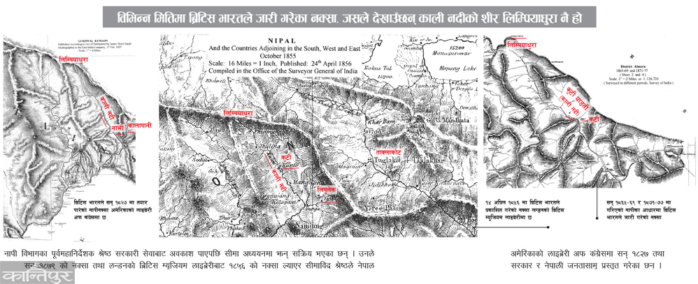
The Sugauli Treaty on March 4, 1816 ended the war between Nepal and the British and determined the Kali River as the western boundary between Nepal and British India. As the source of Kali river is Limpiyadhura, the flow of this river is the border between Nepal and India. Therefore Kali's head belongs to West India rather than Limpiyadhura, while Kalapani and Lipulek to the east belong to Nepal itself.
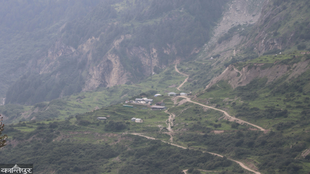
The 370 square kilometer area of Beas Rural Municipality within the Beas Valley is now separated from the reach of Nepal. India places this area in the Pithoragarh district of Uttarakhand. This area is roughly equal to Lalitpur district, Lalitpur has an area of 385 square kilometers.
Kalapani Khoch is around 3600 meters and Lipulek Bhanjang is 5115 meters high. Similarly, Limpiyadhura is at a height of 5500 meters. Lipulekh is historically a route for people movement, going to Mansarovar and trading with China. However, now the Nepalese have access only to 22 kilometers below it.
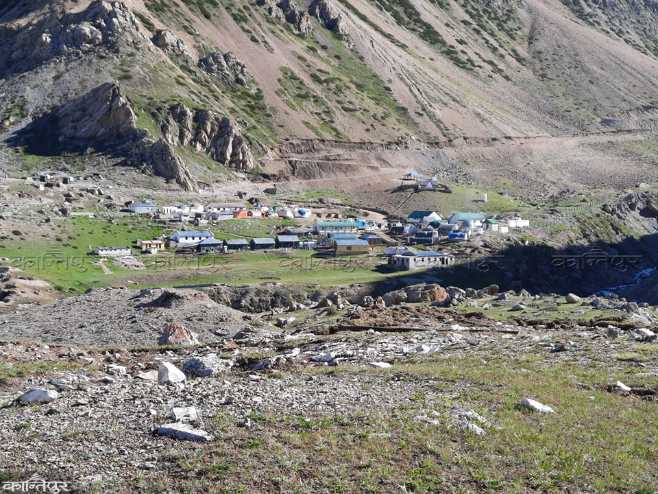
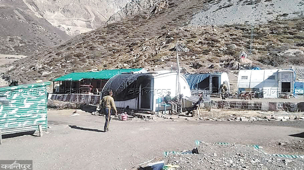
The gate built in Kalapani to allow entry only to pilgrims going to Kailash Mansarovar and Indians going to trade Taklakot reads, 'The Indo-Tibetan Border Police welcomes you.' However, entry is prohibited to Nepalis. While the Nepali traders from Far West with Changru used to travel to Tibet via Kalapani-Lipulek. There was a war between India and China in 1962, but the land was encroached upon by Nepal. Where now Indian paramilitary forces, soldiers and intelligence are stationed for twelve months.
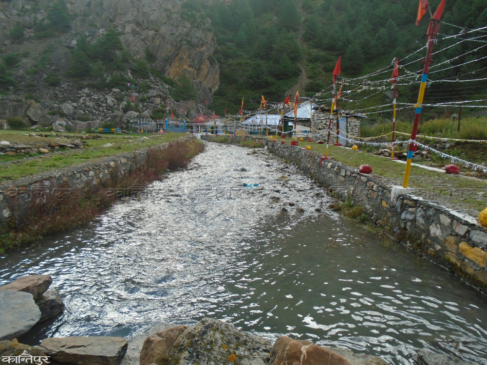
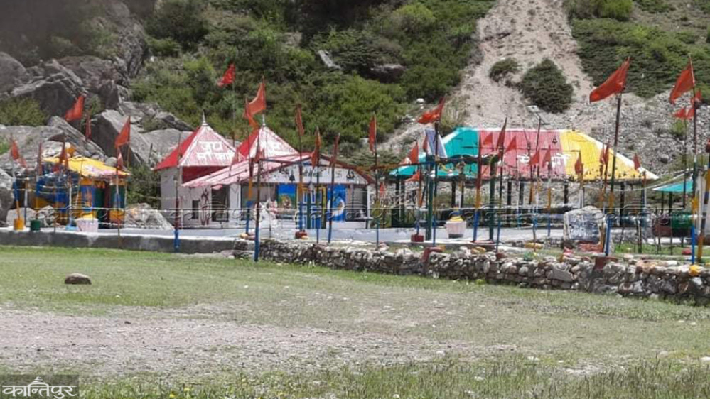
Another river flows from Limpiyadhura, the head of Kali river, next to the military camp deployed by India at Kalapani. That is Lipukhola, but India calls this river Kali River. An area of 370 square kilometers west of the alleged Kali has been encroached by India. On the banks of Lipukhola, the Indian Army has built a temple of Kali, which is called the Kali River.
What is the importance of Kalapani strategically and commercially?
There are old Nepali settlements like Tulsinyurang, Gunji, Kuti, Nabi from the Kali River, but the reach of Nepal is only up to the vicinity of Changru. Kalapani is about 12 km above Changru and 10 km above Kalapani is Lipulek Pass (Bhanjiang) on the Chinese border. India has chosen Kalapani Khoch as the best place to monitor Chinese activities there. It is for this strategic interest that India has encroached on this region.
Limpiyadhura is the trilateral point of Nepal-India-China. However, since it is on the highest mountain, it is difficult to reach there by road. That is why India has named Lipulek, 56 km east, as the trilateral point. Agreeing to the same claim, China has also been agreeing with India to increase religious tourism and trade. India has built a road from Pithoragarh Bazar to Lipulekh which has also facilitated the Kailash Mansarovar journey and trade point. China has also considered this as an opportunity to deliver its products to the vast market of India through a short route.
'Lipulek area is a point of strategic and strategic importance, India has used it for strategic relations and security with China,' says Bishnuraj Upreti, chairman of the committee formed by the government five years ago to study the issue of Limpiyadhura, Kalapani and Lipulek, 'From a commercial point of view, China has also considered this route useful. Both countries have looked after their own interests.'
Why did King Mahendra remain silent when the Indian army entered Kalapani?
Since Sugauli Treaty considered the Kali River as the western border of Nepal, the territory east of Kali belongs to Nepal. Although India has been claiming the land in between as Kali River, Lipukhola to the east. However, Nepal has collected evidence to confirm its claim. Border scholar Buddhinarayan Shrestha has dedicated his life to border disputes and researching the evidence of Nepal.
Shrestha, the former director general of surveying department, has become more active in studies after retiring from government service. He also collected the maps published by the then British India in 1827, 1856 and 1879 which confirm that the river originating from Limpiyadhura is Kali. Shrestha, a frontiersman, brought the maps of 1827 and 1879 from the Library of Congress of America and the map of 1856 from the British Museum Library in London and presented them to the Nepalese government and Nepalese people.
The origin of the Kali River is a matter of controversy, old maps and various facts show that the origin of the Kali River is Limpiyadhura. That's what Nepal has been saying," Shrestha repeated with Kantipur, "After India occupied the Kalapani area in 1962, the dispute over the estuary of Kali took place."
Former Foreign Minister Bhesh Bahadur Thapa has also clarified that the then King Mahendra had information about the presence of Indian troops in Kalapani during the war between India and China.
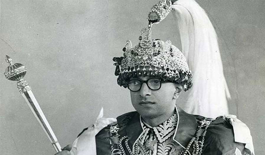
He has written in his book 'Rashtra-Pararashtra', 'In 1962, the war between India and China was intense. At that time, Indians kept security personnel in the Kalapani area overnight. This matter reached King Mahendra," the book says, "Mahendra said that there is currently a war between India and China. It's like we're taking sides when we raise this topic. After the war is over, this issue should be raised and a solution should be found.
After the establishment of democracy in 2007, its roots are connected with the agreement between Nepal and India to reduce the number of Nepali soldiers and give them professional skills.
On 13 February 1952 (1 February 2008) the government of the then Prime Minister Matrik Prasad Koirala opened the way for the Indian 'Military Mission' to come to Nepal to organize and provide training to the Nepali Army. Soon after, on 27 February, the first team of the Indian "Military Mission" came to Nepal.
The Indian soldiers who entered in that way were deployed in 17 places in the northern region of Nepal. After China increased its influence on Tibet, India deployed its army on the northern border of Nepal. However, in the meantime, there was a war between India and China in 1962, after the army was stationed in Kalapani during the war, the number of Indian military posts in Nepal increased to 18.
There were many voices about sending the Indian army back from Nepal, but the final decision was made in 2026. Kirtinidhi Bista, who was the Prime Minister during the reign of King Mahendra, was also in charge of the Ministry of Foreign Affairs. Similarly, Sardar Yadunath Khanal was the Foreign Secretary. On their initiative, the Indian Army was dismissed, but the Indian Army that entered Kalapani in 1962 (2018) was not dismissed. Since then, the border dispute has continued to escalate.
Why the demarcation team of the two countries could not resolve the dispute ?
During the Panchayat period, there was no environment for speaking, border disputes did not get a voice. After the change of 2046, people started raising voices about the boundaries of Kalapani area. Awareness about border crossing increased in the public mind. Political parties and their fraternal organizations made it a political issue. However, even though the border issue got a place in the talks with India, no concrete decision could be made in the direction of solving the problem.
Nepal-India Joint Technical Boundary Committee was formed on November 1, 1981 to clarify the border between Nepal and India. 98 percent of the 1,880 km long border has been completed. However, the committee could not finalize the demarcation of areas including Susta and Lipulek-Limpiyadhura-Kalapani. Nepali technicians reached the Kalapani area as agreed by the technical border committee to conduct a survey in the Kalapani area in 2005. However, the Indian team did not come. Instead, after nearly 26 years, the demarcation process was stopped on 31 December 2007, but the report has not been signed.
After the dissolution of the 'Nepal-India Joint Technical Border Committee', a 'Border Working Group' was formed in 2014 to complete the necessary technical work on the border. However, it also has no right to resolve the Susta and Lipulek-Limpiyadhura-Kalapani disputes. The group only has the 'mandate' to give necessary suggestions in the event that the foreign secretary level mechanism asks for suggestions.
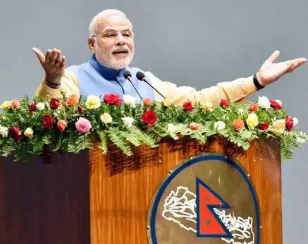
Narendra Modi visited Nepal on 3-4 August 2014 soon after he was elected as the Prime Minister of India for the first time. During talks between the then Prime Minister Sushil Koirala and Modi, it was accepted that about 98 percent of the work on the border had been completed. Both prime ministers agreed to direct the foreign secretaries to work on the remaining border issues including Kalapani and Susta. That practice is mentioned in point number 12 of the joint statement issued at that time. It has been 11 years since the Prime Ministers of the two countries promised to resolve the ongoing issue regarding the border of Kalapani and Susta region forever. However, after that, the border dispute between the two parties is increasing.
In March 2078, even when the then Prime Minister Sher Bahadur Deuba visited India, an agreement was reached to find a solution through dialogue by mobilizing bilateral mechanisms to resolve the border dispute. Then in 2080, during Prime Minister Pushpa Kamal Dahal's visit to India, the commitment to find a solution through diplomatic mechanisms was repeated. However, the foreign secretary level mechanism has not been activated.
 India that China has raised a dispute?
When Indian Prime Minister Narendra Modi visited China on May 14, 2015 (31 Baisakh 2072), a surprising topic was put in the agreement with Li Keqiang. In which it was said, "Both sides agreed to expand border trade through Nathula, Kiangla/Lipulek Pass, Shipki La Pass."
There was a big protest about the fact that both the countries did not even communicate with Nepal about trade or movement using Nepali land Lipulek. The then government led by Sushil Koirala sent diplomatic notes to both China and India as a formal protest.
Bishnuraj Upreti, an expert in international affairs, says that it was the first time that the Nepalese government strongly said that Limpiyadhura, Kalapani and Lipulek are our territory. "The issue of India's encroachment of 370 square kilometers of Limpiyadhura, Lipulek and Kalapani became internationalized from there," he says. The Chinese team that came to Nepal after the
gave a diplomatic response to Nepal if they received the facts and evidence. India has not yet given any official answer on this matter.
Moreover, China and India had agreed to trade through the Lipulek Pass even before that. In an agreement dated 29 April 1954 (17 Baisakh, 2011), both sides agreed to allow pilgrims and traders to pass through Lipulekh. However, analysts say that as a result of Nepali rulers not caring, Indian encroachment is getting more support.
Meanwhile, in the first week of November 2019, India released
a new map showing Kalapani and Lipulekh areas within Indian borders. However, India abrogated Article 370 and 35(1) of the constitution that gave autonomy to Jammu and Kashmir and issued a new map saying that Ladakh had been separated from Jammu and Kashmir, giving legitimacy to it. But after he showed the Nepali land Kalapani area on the Indian map for the first time, Nepal objected by sending a diplomatic note. Nepal also sent a proposal for talks. However, India kept ignoring it. On the contrary, after seven months in early May 2020, India's Defense Minister Rajnath Singh inaugurated the road from Pithoragarh to
 Lipulek . Protests flared up in Nepal after India built a road on Nepalese land When India issued a map or when a road was built in the Kalapani region, Nepal strongly retaliated in both cases. Within 7 months, Nepal had given 'Protest Note' to India twice. However, India ignored both the notes, not wanting to sit in the talks. KP Sharma Oli was the Prime Minister and Pradeep Gyawali was the Foreign Minister. Nepal issued a new map with the then ruling party CPN, opposition Congress, Madhesi parties and RPP all standing together. On May 31, 2077, the proposal to place the map in the schedule of the constitution, approved by the Council of Ministers on May 5, 2077, was approved by the Parliament on May 31. After the amendment of the constitution, the map of Nepal and the Nissan seal were also changed accordingly. The map, approved with an unprecedented national consensus, covers the areas of Gunji, Nabi, Kuti and others in Kalipurva along with Limpiyadhura.
Nepal's new map covering Limpiyadhura, Lipulek and Kalapani regions is known as 'Chuchche Map'. However, Nepal has not yet sent the new map to the international bodies. Instead, the new map released by the northern neighbor China in 2023 shows Lipulekh, Kalapani and Limpiyadhura towards India.
Now what will the government of Nepal do? What should be done?
Upreti says that since Nepal has the historical fact that Limpiyadhura, Lipulek and Kalapani belong to Nepal, they should speak with evidence on both sides. How did they agree to use our land by negotiating without our participation? We have the proof. China also did not see a constructive role," says Upreti, "Prime Minister Oli is preparing to go on a visit to both sides. You have to keep your relationship with both parties with evidence.'
Prime Minister Oli is scheduled to visit both China and India this month. Oli is scheduled to go there to participate in the meeting of the Shanghai Cooperation Organization to be held on August 15 and 16 in the Chinese city of Tiachin. Similarly, he is scheduled to go on an official visit to India from August 31.
In 2077, when Oli was the Prime Minister, the Parliament of Nepal amended the constitution and issued a new map including Limpiyadhura, Lipulek and Kalapani. Now again after India and China have agreed to use Lipulek, reactions are starting to come from all sides of government, house and street in Nepal. The Ministry of Foreign Affairs has expressed its displeasure regarding the fact that the two countries use Nepal's land for mutual trade and no agreement has been taken with Nepal for that, and no information has been given.
Shrestha, the former director general of surveying department, has become more active in border studies after retiring from government service. He brought the 1827 and 1879 maps from the US Library of Congress and the 1856 map from the British Museum Library in London, and Shrestha, a frontiersman, presented them to the Nepali government and the Nepalese people.
 The Ministry of Foreign Affairs has said, "It is known that the government of Nepal has been asking India not to do any activities such as road construction/expansion, border trade in that area. It is also known that China has been informed about the fact that the area is Nepali territory," said a press note issued by Foreign Affairs Spokesperson Lok Bahadur Chhetri on Wednesday. According to the spirit of the close and friendly relationship between Nepal and India, Nepal remains committed to solving the border problem between the two countries through diplomatic means based on historical treaties, facts, maps and evidence.
After the announcement of Nepal,
India's Ministry of Foreign Affairs also responded immediately. External Affairs Ministry Spokesperson Randhir Jaiswal claimed that trade between India and China started in 1954. This business has been disrupted in recent years due to Covid and other developments. He says that both sides have agreed to resume it. “Our old position on territories remains clear and consistent. Our view is clear – that such claims are neither justified nor based on historical evidence,” said the Indian reply, “any such unilateral artificial geographical claim is unacceptable. India is open to resolve existing border disputes through diplomatic dialogue.' While the relationship between Nepal and India is developing, mistrust has increased again since Wednesday.
Related news
'Kalapani dispute will be resolved immediately if we sit and look at the evidence'
