The then correspondent of Kantipur, Narayan Wagle (later Editor-in-Chief) exposed India's strength and intentions in the Kalapani area through on-the-ground reporting in 2053.
We use Google Cloud Translation Services. Google requires we provide the following disclaimer relating to use of this service:
This service may contain translations powered by Google. Google disclaims all warranties related to the translations, expressed or implied, including any warranties of accuracy, reliability, and any implied warranties of merchantability, fitness for a particular purpose, and noninfringement.
With China and India agreeing to open bilateral trade through Lipulek Pass, the Nepalese territory of Lipulek, Limpiyadhura and Kalapani is once again in the center of discussion. Lipulek Pass is a land of Nepal within 56 km from Limpiyadhura, the western border of Nepal. During the visit of Chinese Foreign Minister Wang Yi to India, the border dispute between Nepal and India has flared up again with the agreement to open border trade between the two countries through Lipulekh Pass.
Nepal has not been given any information about the agreement on August 3. Along with the India-China agreement , Nepal has sent different diplomatic notes to both China and India. But both the countries have not returned any reply yet . This issue that keeps on recurring has become like a wound that will never heal for Nepal . India has been claiming the Kalapani area in Nepali territory by force. About 30 years ago, Kantipur daily published local news and revealed the strength and intention of India. The then correspondent of Kantipur, Narayan Wagle (who later became the editor-in-chief) wrote the local news of Kalapani encroachment in the issue of 29 October 2053.
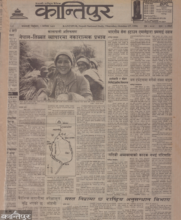
The news published on the front page under the title 'Indian Border Police Camp at Kalapani, Construction of Mahakali's artificial spring by India' highlighted the presence of Indian Border Security Force in the Kalapani area of Nepal's Darchula district. In the news, India revealed that it has set up a camp of the Indo-Tibetan Border Police (ITBP). It was also mentioned in the news that an artificial spring has been constructed with the aim of changing the origin of the Mahakali river. It was mentioned in the news that this area has been under the control of the Indian Army since the Indo-China war of 1962 .

The next day i.e. in the issue of October 30, another news was also published in Wagle's 'byline'. It was mentioned in the news that the tripartite border between Nepal, India and China is not clear. According to the news, although the tripartite border point is not clear, it is mentioned in the news that all the territories including Limpiyadhura, Lipulek and Kalapani belong to Nepal based on the Sugauli Treaty of 1816 and historical maps.
After the India-China war in 1962, India is maintaining control by establishing its military camp in Kalapani. According to the news published in Kantipur at that time, India encroached on the Nepali territory by considering a small river near Kalapani and not Limpiyadhura as the source of Kali river.
The news was published in view of the seriousness of the trilateral border dispute created by India's encroachment in the Kalapani area, the dispute regarding the mouth of the Mahakali river and China's involvement in it. Journalist Wagle presented historical evidence and claims of Nepal and criticized India's unilateral action.
Results after continuous follow-up
In the issue of October 1, journalist Wagle did a 'follow-up story' about Kalapani. In that story, it was written about the encroachment of India in the Kalapani area and its effects. It was mentioned that due to the Indian control, the traditional trade route between Nepal and Tibet passing through that area was blocked and it also had a serious negative impact on the livelihood of the local residents.
After Kantipur published news about Kalapani encroachment for three consecutive days, it became a matter of national interest . As a result of that, this issue gradually started echoing in the streets and houses. On October 2, UML submitted a memorandum to then Prime Minister Sher Bahadur Deuba demanding the withdrawal of Indian troops from Kalapani area. A team led by the then General Secretary of UML Madhav Kumar Nepal submitted a memorandum to Prime Minister Deuba. On the same day, Kantipur Daily also printed an editorial titled "Kalapani and Indian Soldiers".
Journalist Wagle not only wrote about the border dispute in the Kalapani region, but also wrote about the lifestyle there. In the issue of Kantipur on 9 October, a news titled "Darchula residents who are banned from tourism say, Humla will get it, why should we not get it" . In which it was written about the sufferings and hardships of the people of Darchula . Similarly, in the issue of October 11, Wagle wrote about the suffering of the people of Darchula in the news entitled "Darchula people dig roads every day but there is no road in Darchula".
committee formation but silent
After the parties raised their voices in the parliament and on the streets, no committee was formed to investigate Kalapani encroachment. In the news, the government was criticized for not being able to take any decision on whether or not to remove the Indian military camp in Kalapani. As a result of the
news, a parliamentary committee of inquiry was formed . The Parliamentary Inquiry Committee was headed by the then Speaker Ramchandra Paudel . The then Senior Divisional Hydrologist Jagat Kumar Bhusal also wrote an opinion about the origin of the Mahakali river. On the next day i.e. on 19 October, an editorial was once again published under the title 'Kalapani and Indian Army'. In which a proper investigation was demanded .
Shortly after that, ie on November 1, the parliamentary team went to monitor the Mahakali river . The then Speaker Poudel was the leader of the monitoring team. Along with Paudel, Urwadatta Pant, Jhalnath Khanal, Prem Bahadur Singh, Bharat Mohan Adhikari, Bhim Bahadur Rawal, Mahesh Chaudhary, Ramjanam Chaudhary, Subash Chandra Nembang and Hridayesh Tripathi also participated in the monitoring.
They were accompanied by the then Secretary of the House of Representatives Surya Kiran Gurung, the then Director General of Survey Department Punya Prasad Oli and representatives of the Ministry of Water Resources and the Ministry of Foreign Affairs. During the two-day monitoring, the Poudel-led committee concluded that India had encroached on 35 square kilometers of Nepal.
After the decision of the investigation committee, there was a discussion about this border dispute in the parliament, but no decision could be made about it . In the same meeting, accusations were exchanged between political parties. Later, the parliamentary committee concluded that Kalapani was encroached upon. On November 5, Kantipur once again published an editorial saying that the military camp should be removed.
In the issue of January 7, a news headline titled 'India does not agree to limit the Mahakali' was published in the byline of journalist Wagle in Kantipur . Nepal's border dispute was discussed in the meeting of Nepal-India technical level joint border committee held in Dehradun.
Even after that, the then parliamentary committee investigated Kalapani encroachment and the source of Mahakali river. After the investigation committee identified the origin of Kali, the task of clarifying the status of Kalapani was given to the Nepal-India Joint Border Technical Task Force. But the committee could not resolve the dispute. After the
, the then Indian Prime Minister Indra Kumar Gujral, who was visiting Nepal on 23-25 June 2054, promised to agree to resolve the Kalapani issue. However, even for one year as promised by Gujral, no concrete work could be done . Instead, in May 2055, the then Indian Ambassador KV Rajan claimed that Kalapani is Indian territory. In a statement issued by the Indian Embassy in Kathmandu on 20th of June, it was claimed that Kalapani has been an Indian territory since the 19th century.
The then Prime Minister Girija Prasad Koirala claimed that Kalapani belongs to Nepal, taking a dig at the statement of the embassy. In a press conference at his residence, Koirala said in clear words, 'Kalapani belongs to Nepal, I don't know anything else.' Then there was a protest against India.
On 32 June 2055, a team of left-wing students led by student leader Yogesh Bhattarai reached Kalapani. After that, military deployment in Kalapani area was tightened. In addition to adding fences to an additional 1,500 meters of Nepalese territory, more security personnel were deployed under the command of a colonel, who was previously under the command of a major.
India didn't stop there, India also claimed Kalapani as its own during the Nepal-India joint technical meeting on 1 July 2055. After India claimed the Nepalese territory, the then Prime Minister Girija Prasad Koirala discussed Kalapani with his Indian counterpart Atal Bihari Bajpayee at the SAARC meeting held in Colombo on 12 July 2055.
The Nepali side continued to repeat its claim in the Kalapani region . But India did not take it lightly. On 7 July 2056, the then Prime Minister Krishna Prasad Bhattarai also reiterated Nepal's claim to Kalapani once again. After that
 , on July 17, 2056, the then Chinese Ambassador Jay Zewang expressed the opinion that there should be a discussion between Nepal, India and China on the issue of Lipulek-Limpiyadhura tri-national border point. But later China stopped showing interest in this . On 26 August 2056, the Kalapani issue was discussed during the visit of the then Indian Foreign Minister Jaswant Singh to Nepal. Later, on 30th June 2057, Indian ambassador KV Rajan also said that Kalapani can be left if Nepal is seen. Then on 16 July 2057, during the then Prime Minister Girija Prasad Koirala's visit to India, it was agreed to finish Kalapani and give this task to the Joint Border Technical Committee. In the committee meeting held on 29th June 2064, both parties presented their claims. But even then, there was no progress on the issue of Kalapani. On the contrary, on 1st June 2072, a written agreement was reached between India and China to make Lipulek a trade port. In opposition to that, Nepal sent a 'diplomatic note' to both India and China.
India published a new political map
on 16 October 2076 including the Kalapani region of Nepal . In response to that, on October 20, the Ministry of Foreign Affairs of Nepal issued a statement saying that unilateral maps are not valid. Then in June 2077, the government issued a new map including the territory up to Limpiyadhura based on the Sugauli Treaty. The map was unanimously approved by the Parliament . However, even after that, India's border encroachment continues in the Kalapani area. Other news related to
The border dispute that keeps blurring the faith
Why does the Kalapani issue keep burning? Understand in seven facts
Diplomatic note to India 8 times in 10 years regarding the border, all unanswered
Chuchche map we read in the book, how did it disappear ?
Nepali Role 17 Why didn't the Indian Army withdraw from Kalapani when the check post was withdrawn?
