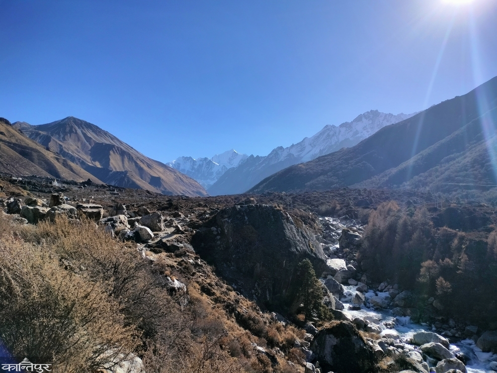
The mountains, the valleys, and the beautiful white mountains in the background! To the east and south were Dorje Lakma and Yala Peak, to the north were Langtang Lirung and Gangchampo!
We use Google Cloud Translation Services. Google requires we provide the following disclaimer relating to use of this service:
This service may contain translations powered by Google. Google disclaims all warranties related to the translations, expressed or implied, including any warranties of accuracy, reliability, and any implied warranties of merchantability, fitness for a particular purpose, and noninfringement.
To me, going on a long journey to the lake feels like meditating in solitude to look deeply into my inner self. It feels like letting go of all my fibers and then re-engaging and tightening the loose ones. Rubbing rusty joints with mud, cleansing the walls of my lungs that are covered in smoke with the scent of incense, weighing, weighing, and releasing the dimensions of a deep relationship like a running camel, and carrying it with a thousand tangles, like a snowdrift, like a snowdrift.
When I need mental strength to live life as it is, I go on a long journey to the mountains. During the journey, I get squeezed, squeezed, filled up somewhere, scattered, gathered again and return home as a whole person. My family sees my tired, exhausted body, but I see the whole ‘I’ flying, floating within me. Who has come ready to fight with the world again for a few days, a few months.
My mind and brain were looking for energy. I was looking for a friend to go on a journey. While the short day of Poush was winding down, Anil BC and I set off on a motorcycle via the Tokha road to Syafrubensi at 3 pm. Leaving the hustle and bustle of the Kathmandu crowd here and there and entering the Shivpuri-Nagarjuna National Park, it felt like the exciting beginning of the Langtang trek. Freed from the hassle of waiting for a bus/jeep ticket of my choice from 900 to 1400 rupees at the ticket counter for Syafrubesi towards Balaju Machhapokhari Chowk, I was enjoying the forest behind the motorcycle ridden by my friend. As we left Kathmandu and started descending towards Nuwakot via a broken or otherwise good blacktop road, we saw settlements. This road, which we had descended many times before, showed us the Ganesh and Langtang mountain ranges playing hide-and-seek in the clouds from Gurje Bhanjyang. We were going near those same mountains. So we did not have time to stop because we were tempted. Flowing with the view, we left Chhahare, crossed the fields of Ghattekhola and reached Battar. After moving forward from Trishuli Bazaar, immersed in the maze of darkness and light, we reached Betravati at around 6:30 pm. From here, one road descended to Syafrubesi via Dhunche, while the other road went to Syafrubesi on the banks of Trishuli. The road to Syafrubensi, which is right on the banks of the Trishuli, was short, but it was also difficult because it was a dirt road. Even though it was difficult because time was running out, we chose the shortest route.
After riding on the blacktop road for some time, we were on a dusty road. We kept moving forward, adding layers of suffocating dust one after another, in the darkness, the Trishuli roaring in the canyon below, and the occasional truck blowing in. Sometimes the dust that a motorcycle blew, sometimes the muddy road, sometimes the fear of falling rocks stuck in landslides, we reached Syafrubensi, where we were about to sleep, at 9 pm.
Leaving Syafrubensi Bazaar, which is located at the confluence of the Langtang River and the Bhotekoshi, known as the Lhende River in Tibet, we went to the place where the motorcycle was parked, and continued on with the sound of staying at the hotel. It was a new place for us, and since it was dark, we couldn't find any food. We reached a place called Tiwari. We left the house that looked like a hotel with no lights on across the suspension bridge and went further. We saw a house with lights on from a distance. We rushed to get there. It turned out to be the quarters of workers who were building a dam on the Langtang River. After leaving Syafrubensi and having to walk so far, we finally remembered our aching bodies. We remembered hunger, fatigue, and sleep. Fearing that the hotel in Syafrubensi would be closed too, we quickly returned and stopped our motorcycles in the courtyard of 'Hotel Old Namaste' and entered. Happy to welcome travelers to Langtang in this off-season, the hotel owner, Sonam Tshiring Tamang, hurriedly served delicious food. Since it was not the travel season, the hotels above were completely empty, so we said that we could go without worrying about accommodation. I don't know how long I had been playing with the melodious sound of the Bhotekoshi flowing below, the body hunched over while sitting on the back of the motorcycle, the pleasant imagination of tomorrow's journey, and the laughter of my fellow travelers.
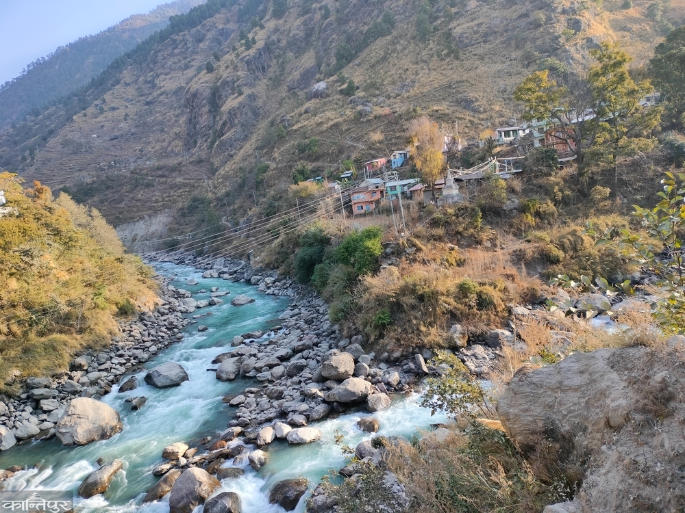
After the light entered the window of the hotel standing on the hill above the Bhotekoshi gorge, we got up and had breakfast and set off. We had left our motorcycles at the hotel. Now we had to walk on the dirt road that had been dug up while searching for a hotel at night. To leave this small market nestled in the lap of the winter-swept mountains, we crossed the bridge and followed the Langtang River past the tunnel and hydropower works that were being done on the mountainside. The river flowing between the rocky slopes on both sides was telling its story of the years. We kept walking, watching the fertile stories of the mountains cut by its incessant quarrying, carved stones and irrigated fields. Looking at the river, the pine bushes clinging to the rocky mountains above were murmuring like a river. We reached Domen (1565 m) in 1.5 hours by passing through Tiwari (1553 m). The unpaved road that had come to the place where the hydropower dam was being built had now ended. After climbing up for a while, we crossed a suspension bridge and reached a settlement with 3/4 small houses sitting on the side of a beautiful hilly river. There was a neat Domen Riverside Guesthouse. Our real journey finally began from that guesthouse, like a tea shop in the foothills. The climb was now ahead of us.
From the path that rose up through the Nigala valley, I saw the houses in the foothills. From above, those houses with crab-like caps looked as if they were discussing some important matter with each other. It seemed that Dobhan was called Domen because it was a settlement where another Lekali river joined the Langtang River. There was not much climbing here. I left my friend on the horizontal path and continued forward. After some time, I saw a landslide (1722 m.) cooking breakfast among the trees. The place was named after the landslide because it was a settlement where a large landslide had once occurred. I followed the river towards the landslide with smoke coming from it. As I approached the landslide, I saw a wooden bridge crossing the Langtang River, and after crossing it, the owner of the local ‘Namaste Guesthouse’ told me that I would reach the source of the hot spring. On my way back, if I had time, I thought that I would relieve the fatigue of the journey by sitting in the hot spring. Up from the landslide, I saw large syafru houses. From there, there was a road to Gosainkunda via Chyolangpati and Lauribina. I moved forward, giving the landslide hotel, which was perched on a rocky cliff, time to get busy with its business. While walking along the path above the landslide, I saw a huge honeycomb on the cliff across the river. Seeing that there was nothing else to do except imagine and take photos and remember ‘The Last Honeyhunter’, directed by Ben Knight, I waited for my friend to ask me to take a photo. After taking the photos, I left the honeycomb hanging on the rock there and continued my journey through the forest.
I gave my friend enough time to walk ahead and stayed a little behind. Now I was in the dense forest. Across the way was a white waterfall, below was the symphony of the ravine, there were trees of Uttis, Katus and Chilaune. I kept on walking, having a double conversation with myself, digging myself, breaking myself, and snorting. It was only when I had time for myself that I walked leisurely. I walked, enjoying my me-time. As the road slowly descended towards the river, the Nigala bushes began to appear and houses appeared on the banks of the river. Even when we went to the Annapurna Base Camp, the name of the place where the hotel was located next to the Nigala grove was Bambu. Here too, Bambu (1984 m.) was there. I headed towards Bambu, keeping an eye out for the red panda, or Habre, which lives on Nigala and bamboo. We arrived in about an hour and a half from the landslide.
Anil had already ordered food at the Sherpa Guest House. We ate, disappearing into the white foam that came out of the Langtang River, crashing into the jagged rocks. Rajkumar Tamang Bhai told the story of the Tamangs of the Langtang region who prefer to be called Sherpa and Tamang. The Sherpa from this place, which has close ties to Tibetan culture, had written Tamang because of the difficulty in citizenship. It was at the hotel in Syaphru that the Sherpa had written Tamang. After eating, we moved towards Rimche with heavy bodies. The mountain river was talking to the bamboo trees above. We sat on the wooden bridge for a while and tried to understand the river. After taking some photos of its movement, we followed the path welcomed by reeds, cedar trees with moss growing on them, and green leaves of khasru. We sat and watched the Langtang flowing down from the suspension bridge, ready to cross us.
The suspension bridge also watched the rushing water flowing from somewhere and going somewhere far away. The Lungdas, who were tied to the bridge like us, also waved goodbye to the rushing Langtang. There were snoring on both sides of the uphill path. We kept crawling uphill, weighed down by the heavy load. At that moment, we met the porters who were coming down, picking up the snoring. The brothers who had reached the sky with heavy loads were descending, collecting fresh vegetables. Ahead came a narrow path, where they found a small tea house. We continued to move forward, eating the lunch we had in our pockets. We took it lightly as we moved forward from the signpost of the Rimche landslide (2252 m). It was almost scary to see the life that had just come from the uphill path, the dry landslide that had fallen from the mountainside as far as the eye could see, the stones still stuck in the landslide, and the slow soil moving. Looking up, carrying a heavy bag and crossing the damaged road quickly, it was like our heart was beating out of our chests. During the earthquake, Israeli citizens were killed in this landslide. When we reached a little higher after the landslide, it was even more heartbreaking to read the description written on the wall. It seemed like we had survived. A little ahead, there was a group of black-faced langurs in the tree. Taking photos from afar, we left that group and reached Rimche in two hours and 10 minutes. After the ascent, we had a cup of coffee from Rimche (2509 m) and started our journey. It took us 50 minutes to reach Lama Hotel from here. Lama Hotel, located in the valley of Uttis, is at an altitude of 2515 meters. People who have walked from Syafru come here to stay. We reached there at 4:30. We thought of making good use of the remaining time. We continued our journey by staying at the riverside for today.
The words of the ‘Lama Hotel’ attendant, mixed with the warning ‘Don’t walk in the night, the bear will come,’ did not stop us. The stone-paved path slowly led us. We kept walking along the river to the right. After leaving Lama Hotel, we finally saw the beautiful mountains. The dim sun was entangled in the branches of the cedar trees. We moved forward, following the darkness of the forest. Slowly the moon rose in the sky. Without lighting the lamp, the path became invisible. We were walking silently. In one mind, we felt that we should have stayed at the ‘Lama Hotel’. Now there was no choice but to walk. After walking for about three and a half hours, we saw a light somewhere in the darkness. We were reaching there with a heavy heart. We slowly moved towards the light and finally reached ‘Riverside’ (2770 m).
Riverside is also called Gamnachowk. We set up our bags at this hotel on the banks of the Langtang River. We sat around the fire. Tamang Dai was probably not in a very talkative mood today. After Dai answered the long question we asked with a shake of his head, it was best to eat dal, rice and potato vegetables and go to sleep. Even though we slept through the river all night, we did not find anything because we were in a deep sleep.
As soon as I woke up in the morning, I went out. There was a cedar forest above the hotel where we were staying and a treeless brown rocky mountain above. After looking around for a while from the bank of the Langtang River in front of the hotel, I returned. It was 8:32 in the morning when I left after eating gram and roti. Some mules were also having breakfast like us. They put the gram and maize they ate in a sack bag that fit in their mouths and sewed it over their ears. Then they ate it without chewing. As we moved forward from here, a hotel came and we moved forward from a place like a museum of stones. Small mountain streams tempted us and stopped our pace. We stared at it and moved forward with force. A beautiful meadow came in front, from where Langtang Lirung looked even more beautiful.
The sun was shining on the tops of the mountains. Below that, there was also sun on the gray, black mountains. The sun had not yet reached the meadow where we were walking and the tall cedar trees beyond. This sun-shadow hide and seek had created a magical world. खर्कमा चौंरी गाई चरिरहेका थिए । हामी १०ः५० मा घोडातबेला (३००८ मि.) पुग्यौं । विसं २०७२ को भूकम्पले घोडातबेला, थाङ्स्यापदेखि लाङटाङ गाउँसम्म असर गरेको रहेछ । पहिरोले गर्दा घरहरूमा क्षति पुगेकाले केही सारेर बस्ती पुनर्निर्माण भएको रहेछ । हामी चिसोले गर्दा जमेको हिलो माटोमा होसियारीपूर्वक हिँड्दै थियौं । पानीका खोल्साहरू जमेको किनारासँग झगडै गरेजसरी सकी नसकी जबर्जस्ती बग्दै थिए । हामी पातविहीन अनौठो देखिने रूखमुनिको प्राकृतिक स्वागतद्वार भएर १२ः२० बजे थाङ्स्याप (३२०५ मि.) पुग्यौं । यहाँ अमिलो न अमिलो डालेचुकको जुस खायौं अनि ‘खाना अर्डर’ दिएर आराम गर्न थाल्यौं । काला चट्टानको पहाडसँगै जोडिन खोज्दै बसेको यो बस्ती प्राकृतिक प्रकोपबाट सुरक्षित थिएन । दाल, भात र आलुको तरकारी थपीथपी खाएर हामी बाटो लाग्यौं । हिउँदे सुकेका पहेंला/खैरा घाँसले लाङटाङ उपत्यकालाई आफ्नो अँगालोमा बाँधेका थिए । हामी छम्कीको छिरिङ थेन्दुको ‘पिसफुल रेस्टुरेन्ट’ मा पस्यौं ।
८९ वर्षका छिरिङ थेन्दुले चौरीको दूध तताउँदै लाङटाङको कथा सुनाए । तिब्बतको केरुङमा चाड मनाउन मानिसहरू जम्मा भएका थिए । गोरु र नाक (ब्री) मारेर मासु खाने तयारी हुँदा दाम्लो छिनालेर गोरु र नाक (ब्री) त्यहाँबाट भागे । त्यो देखेर थुर्पु गेन्जेन नामको मानिस त्यहाँबाट तिनलाई समात्न पछ्याउँदै आए । लाङटाङ नाम लाङ (याक/गोरु) र ‘टाङ (पछ्याउनु) भन्ने अर्थबाट आएको हो । उनै थुर्पु गेन्जेनका सन्तान लाङटाङका बासिन्दा हुन् । यति कथा सुनाएर उनले हामीलाई कपमा दूध दिए । हामीले चौंरीको दूध खायौं । ‘अब त चौंरी निकै कम भइसके, आफू बूढो भइगैयो, नयाँले दुःख गरेर पाल्दैनन्,’ उनले दुखेसो पोखे । ‘विदेश जान तयार, नभए भारी बोक्न तयार, तर आफ्नो पुर्ख्यौली पेसा अपनाउन पछि हटिरहेका नयाँ पुस्ता नेपालका तराईदेखि हिमालसम्मै भइसकेका छन्,’ यति भन्दै म उठें । हामीले ३ सय तिर्यौं र फर्कंदा फेरि पस्छौं भनेर निस्कियौं ।
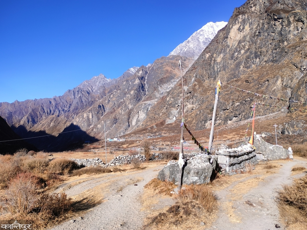
लाङटाङ गाउँ आउनुभन्दा अगाडि पहिरोले सारा गाउँलाई छोपेको ठाउँ आयो । भूकम्पमा माथिबाट हिमपहिरो झर्दा १७६ जना स्थानीय, ८० जना विदेशी, १० जना सेनाको मृत्यु भएको रहेछ । हामी गाउँ नै सखाप भएको त्यस स्थानबाट चुपचाप हिँडेर अहिले बसेको लाङटाङ (३२२० मि.) ४ः११ बजे पुग्यौं । पत्थरका दुई पहाडबीच लाङटाङ गाउँ शान्त थियो । बिस्तारै हुस्सुले ढाक्दै लगेकाले हामी यहाँ नरोकिई मुन्डु लाग्यौं । मुन्डु उक्लने क्रममा पुनः एक पटक फर्केर लाङटाङ गाउँलाई हेरें । सूर्यास्त हुँदै गरेको आकाश, हुस्सुले क्रमशः आफ्नो अँगालोमा बेर्दै लागेको पहाड र आफ्नो हृदयमा उमारेर राता भुइँ झार ! हजार पीडा लुकाएर यो सुन्दर बस्ती मुस्कुराउने चेष्टा गर्दै थियो । बुद्धका मन्त्र कुँदेका पवित्र ढुंगाको बाटो भएर हामी ‘एभरेस्ट एको लज’ मुन्डु (३२१३ मि.) पुग्यौं । भूकम्पपछि यताका लगभग सबै संरचना नयाँ बनेका रहेछन्, त्यो वैभवशाली संस्कृति सिमेन्ट र छडमा साटिएको रहेछ । अब बसेपछि मात्र चिसोको महसुस भयो । म आफ्नो कोठामा सिरकमा घुस्रिएँ भने अनिल न्यानो भान्सातिर आगो ताप्न गए । हामी नेपालीको प्रिय खाना त्यही दाल, भात खाएर त्यो रात सिरक खापेर सुतियो । झ्यालबाहिर माइनस ८ डिग्रीको चिसोको साम्राज्य थियो ।
बिहान ७ बजे उठेर शौचालय जाँदा सबै पनि जमेको रहेछ । धुवाइरहेको भान्छामा पसेर भनें । छुट्टै भाँडामा तातोपानी लिएर शौचालय गएँ । अनिल उठेपछि ब्याग कसेर तातो भान्छामै गएर बस्यौं । अब हिमपात सुरु भएपछि लगभग शून्य हुनेरहेछ गाउँ । तातोपानी दिँदै होटलकी दिदीले भनिन्, ‘कोही काठमाडौं जान्छन्, कोही स्याफ्रुतिर झर्छन् । गाउँमा बस्नै कर पर्नेबाहेक कोही हुँदैन । अहिल्यै आधा मानिस हिँडिसके ।’
चिया, खाजा खाएर हामी ८ः१६ बजे क्यान्जिन गुम्बातिर लाग्यौं । मौसम सफा थियो । पन्जाले पनि हातलाई जोगाउन हम्मे परेकाले मैले दुवै हात ज्याकेटमा हालेको थिएँ । रातिको शीत झाडीमै जमेर झाडीहरू सिसाको खेलौनाजस्ता बनेका थिए । चिसोले पाइप फुटेका ठाउँमा पानी माथिसम्म पुगेर अचम्मका हिउँका आकृति बनेका थिए । हामी घामको कलिलो किरणमा नुहाउँदै पुसको लेकको सुन्दरतामा रमाएर हिँडिरहेका थियौं ।
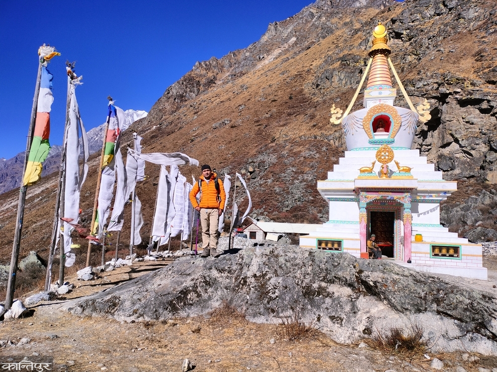
लगभग आधा घण्टापछि सिन्दुम (३५५५ मि.) आयो । घामको आनन्द लिँदै चरिरहेका घोडा, खच्चड र याकले हाम्रो यात्रालाई साथ दिए । ती पहेंला घाँस र झिक्राझिक्री जे भेटिन्छ, खोज्दै खाइरहेका थिए । हाम्रो बायाँ माथि विशाल पत्थरे पहाड, त्यहाँ माथि हिमाल थियो भने दायाँ तल खोंचमा खोला र अर्को पहाडको शृंखला फैलिएको थियो । हिमालको फरक भूबनोटमा हामी रमाउँदै ११ः३० बजे क्यान्जिन गुम्बा (३८७० मि.) पुग्यौं । बाटाबाटामा उठाएका माने, लुंदर अनि फैलिएको उपत्यका र त्यसको पृष्ठभूमिमा सुन्दर सेता हिमाल ! अब हिमाल हाम्रा हातैले छुने दूरीमा जत्तिकै नजिक थिए । हाम्रो पूर्व र दक्षिण भेगमा दोर्जे लाक्मा र याला पिक थिए, उत्तरतिर लाङटाङ लिरुङ, गङचम्पो थिए ।
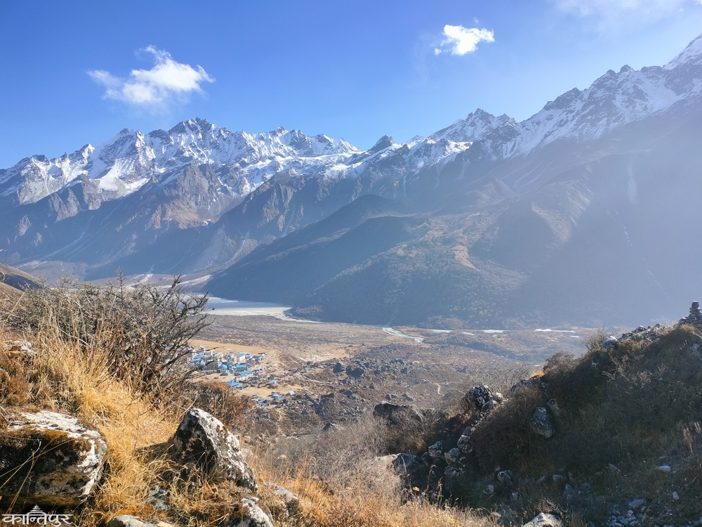
हामी होटलतिर नछिरी सिधै लाङटाङ लिरुङ ग्लेसिएर तालतिर लाग्यौं । लगभग डेढ घण्टाको उकालो चढेपछि हामी तालमा पुग्यौं । मेरो आँखा अगाडि विशाल जमेको ताल थियो । झोला किनारामा बिसाएर म तालमा हिँड्न थालें । ठूलो र मोटो सिसाको पत्रले ताललाई ठोस बनाएको थियो । यो ग्लेसियर ताल बनेको त्यस्तै ४०/४५ वर्ष मात्र भएको एभरेस्ट एको लज मुन्डुकी साहुनीले भनेकी थिइन् । पृथ्वीको तापक्रम बढेर जन्मिरहेका यस्ता ताल फुटेर तलका बस्ती जोखिममा पनि पर्ने हुन्छन् तर यहाँ ताल पनि नफुट्ने र मज्जाले तालको प्रयोग पनि हुने काइदाको उपाय गरिएको रहेछ । यो तालबाट लाङटाङ माइक्रोहाइड्रो परियोजना चलाइएको रहेछ, जसले ११० किलोवाट बिजुली निकाल्दो रहेछ । लाङटाङ ग्लेसियरमाथिको लाङटाङ लिरुङ, अर्कोपट्टिको याला पिक अनि दोर्जे लाक्पा हिमाल हेर्दै हामीले खाना बिर्सेर दिउँसोभरि त्यही तालमा समय बितायौं । मेरो लगाम मैले मभित्रको बाल्यावस्थालाई दिएँ । मैले तालमा सुस्त हिँड्ने, कसरत गर्नेदेखि बस्ने र लडिबुडी खेल्नेसम्मका क्रीडाकौतुक गरें । बिस्तारै साँझपखको चिसो हावा र हुस्सुको आगमनले हामी तल झर्न बाध्य भयौं ।
माथिबाट देखिने रंगीन आधुनिक घरहरूको क्यान्जिन गुम्बा झरेर हामी वर्षौं पुरानो मानिने गुम्बा गयौं । स्थानीय तामाङ समुदायको धार्मिक तथा सांस्कृतिकको केन्द्र मानिने यस गुम्बाको दर्शनपछि विसं २००९ सालतिर खोलिएको चीज उत्पादन केन्द्र हुँदै होटलमा पुग्यौं । क्यान्जिन गाउँको सिरानबाट क्यान्जिन रि (४,७७३ मि.) हामीलाई हेर्दै बसिरहेको थियो । भोलि बिहान ४ बजे नै क्यान्जिन रि सूर्योदय हेर्न जाने तय भयो । होटलकी साहुनी आमा पर्सि होटल बन्द गरेर काठमाडौं जान मालताल मिलाउँदै थिइन् । उनले शेर्पा लवजमा ‘अब एक/डेढ महिना यो गाउँ खाली हुन्छ’ भनिरहँदा म सुनसान क्यान्जिन गुम्बाको कल्पना गर्न थालेको थिएँ । सेतो हिउँको बर्को ओढेको सुनसान क्यान्जिन गुम्बामा सायद हिमचितुवाको राज हुन्छ होला त्यो बेला ! खाना खाएर पैसा तिरेको एक थर्मस पानी सिराननेर राखेर हामी सुत्यौं ।
बिहान अँध्यारैमा पानी, खाजा बोकेर हामी बिहान ४ः३० बजे उकालो लाग्यौं । बिस्तारै उज्यालो हुँदै गर्दा हिमालहरूले आफ्नो चमक देखाउन थाले । हाम्रो शरीरबाट भने शक्ति निचोरिएर हामी एक–दुई पाइलापश्चात् आराम खोज्ने भइसकेका थियौं । जत्ति हिँड्दा पनि नआउने शिखर, जत्ति जोगाउँदा पनि न्यानो नहुने हात अनि जत्ति लिँदा पनि नपुग्ने प्राण वायुसँग अघोरै रिसाउँदै हामी घस्रँदै थियौं । बल्ल–बल्ल ६ः३० बजे हामी क्यान्जिन रिमा पुग्यौं ।
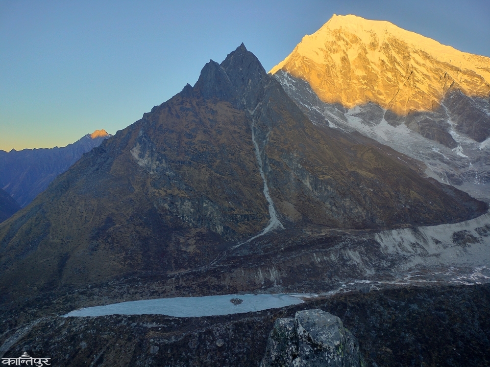
सूर्योदयको आभाले लाङटाङ लिरुङ हिमालमा घामका किरण पोतिए । सुनौलो आभाले यो चम्किएको देख्दा मन प्रफुल्ल भयो । लाङटाङ लिरुङ, याला पिक, दोर्जेलाक्पा अनि हिमनदी र जमेको हिमतालका साथै पूरा उपत्यका यहाँबाट देख्दा हामीले निद्रा माया मारेर यहाँ आएको सार्थक भएको थियो । हामी यात्राको समीक्षा गर्दै फोटाहरू पनि खिच्दै थियौं । दिनको २००० देखि २५०० खर्चमा ५/६ दिनमा आरामले पूरा गर्न सकिने यो यात्राको शिखरमा हामी थियौं ।
आजै हामीलाई फर्कनुपर्ने भएकाले अर्को जानैपर्ने गन्तव्य सेर्गो रि जाने योजनालाई बलैले दबायौं र तलतिर झर्न थाल्यौं । शिखरमा पुगेपछि केही क्षण रोकिने मात्रै हो, अन्ततः तल झर्नैपर्ने सत्य मनन गर्दै हामी बिस्तारै चारैतिरको सुन्दरता आँखामा कैद गर्दै झर्न थाल्यौं ।
