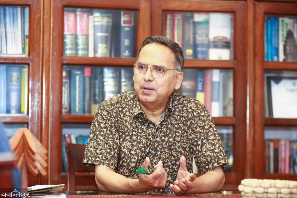
Bipin Adhikari, a constitutional scholar and a member of the working group to find evidence of the border and Sugauli Treaty, said that Article 5 of the Sugauli Treaty states that Nepal will not claim the areas west of the Kalinadi River and that all areas to the east belong to Nepal.
We use Google Cloud Translation Services. Google requires we provide the following disclaimer relating to use of this service:
This service may contain translations powered by Google. Google disclaims all warranties related to the translations, expressed or implied, including any warranties of accuracy, reliability, and any implied warranties of merchantability, fitness for a particular purpose, and noninfringement.
Bipin Adhikari, a constitutionalist and a member of the working group to find evidence of the border and Sugauli Treaty, has claimed that the Chuchche map has been mentioned in the curriculum of Nepal in the past.
Speaking to Kantipur, the senior advocate officer claimed that Lipulek, Limpiyadhura and Kalpani are part of Nepal, and there were Chuchche maps in the course, but they gradually disappeared and became Buchche. He said that he could not say anything about how he got lost in the course because he did not study.
'You didn't know what you read . But when I studied at school, Chukche was the only map. The peaks of Lipulek, Kalapani and Limpiyadhura were mentioned in those maps. It's not too old either. Why is it lost in the textbook?'' The officer said, 'When looking for the answer, it is obvious that the map is not made in Nepal.' The textbook was not made in Nepal. In Nepal, people were also sold . They were sold and the Chukche map was lost. Otherwise, how did the Chuche map mentioned in the textbook when we read it disappear in your time? People buy and sell. Textbooks can be revised and made new, but the treaty is a document signed by both parties. ’
He said that in Article 5 of the Sugauli Treaty, it is mentioned that Nepal will not claim the area west of the Kali River and all the areas to the east will belong to Nepal . He claimed that Kalindi also belonged to Nepal and all the Nepali territories before that. He said that we have agreed on Kalindi and all areas of that Wari after losing a huge Nepal during the unification of Nepal.
The maps made by British India of the Sugauli Treaty are official maps. All the maps made after that are one-sided . Because these are made by India and customized. Now the agreement that we are saying to make is going to be bilateral' he said, 'Now the question has been raised whether Limpiyadhura is the place of origin or not. Indians have been saying that Limpiyadhura is not the origin of Kalindi, this is based on wrong logic and facts. This is not true. Simply look It is not the main demand of the nadi and the subsidiary demand which can be shown in Lipulek Indian region if maintained. How can it be considered to be the origin of that era? The hole is never opened. The river bank and original source can still be traced. ’
In the campaign of Nepal's unification, Kumaon, Garhwal and other areas in the western region of Kali were integrated into the Gorkha state. Article 5 of the treaty said that even though Nepal has integrated the western part of the country, there will be no claim in the future.
It is said that Nepal (the then Gorkhas) will not claim the Kali river and the land to the west of Nepal. These parts are said to be India. The legal interpretation is that the Kali river is the border but only the western part of it belongs to India. As this is mentioned in the treaty, all the territories in the east including Kalindi belong to Nepal . Awa Kalinadiko Shir Of course, the place of origin is Limpiyadhura. Kali river flows from there. That's why Shiran and its rising river course are all areas before it are Nepali.'
He claimed that the maps made by British India of the treaty are official maps. All the maps made after that are one-sided . Because these are made by India and customized. Now the agreement that we are saying should be bilateral," he said, "Now the question is being raised whether Limpiyadhura is the place of origin or not. Indians have been saying that Limpiyadhura is not the source of Kali river, this is based on wrong logic and facts. This is not true .'
Read the detailed conversation of Kantipur with Bipin Adhikari, a member of the working group to find evidence of the border and Sugauli Treaty.