Most of the residents of Deukhuri, the capital of Lumbini Province, Dang, do not own land. The capital city is located on public land there. Bhalubang Bazaar in Rapti Rural Municipality-1 is also located on public land.
We use Google Cloud Translation Services. Google requires we provide the following disclaimer relating to use of this service:
This service may contain translations powered by Google. Google disclaims all warranties related to the translations, expressed or implied, including any warranties of accuracy, reliability, and any implied warranties of merchantability, fitness for a particular purpose, and noninfringement.
Under the direction of the federal government, an 'Urdi' is being issued across the country to clear squatter settlements, encroached and public lands. In the capital Kathmandu and some big cities, dozers have been used on encroached structures. Many local governments are issuing notices and giving 'ultimatums' to clear public lands. Industrial, protected areas and district forests have issued notices asking to clear encroached lands.
However, the country's big and famous cities have developed on public lands. Big cities have settled on open/parti lands along the east-west Mahendra Highway. The local government has the right to protect such open lands. The settlement development taking place on such lands has now become a headache for the federal and local governments. After the protection of public lands was started, the unorganized settlers who have been living in open houses for years are agitating.
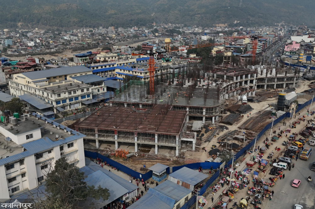
Most of the residents of Deukhuri, the capital of Lumbini Province, Dang, do not own the land. The capital city is located on open land there. Bhalubang Bazaar in Rapti Rural Municipality-1 is also on public land. Spread over a total area of 31 bighas, 7 kattas, 13 dhurs, Bhalubang has about 1,300 houses in the national forest and Chure area. Jagat Pokharel, former president of the Rapti Chamber of Commerce and Industry Bhalubang, said that settlement here began in 2027 BS. ‘Currently, there are at least 450 businessmen in Bhalubang Bazaar,’ he said, ‘but none of them have land ownership certificates.’ He said that the market is becoming more lively due to these businessmen. Most of the settlements in the northern part of Kapilvastu are also on public land.
The three big cities of Rupandehi are on unclaimed land. Most of the settlements in Devdaha Municipality, north of the Mahendra Highway, the Ukas River area of Tinau in Butwal, and Murgiya in Sainamaina Municipality are on unclaimed land. The three big cities of Rupandehi are on public land. Most of the settlements in Devdaha Municipality, north of Mahendra Highway, Tinau River Ukas area of Butwal, and Murgiya of Sainamaina Municipality are on public land. The government owns the land where large houses and commercial buildings of individuals are located. Land and houses without ownership documents are being bought and sold for millions of rupees. The government does not receive revenue from such transactions.
The local government has provided electricity, drinking water, telephone and other facilities to such settlements. Roads have been blacktopped at a cost of crores of rupees by the government. An average of 2,000 to 2,500 houses are added to the three big cities of Rupandehi every year. The local government collects revenue for the approval of the plans for the houses constructed in this way.
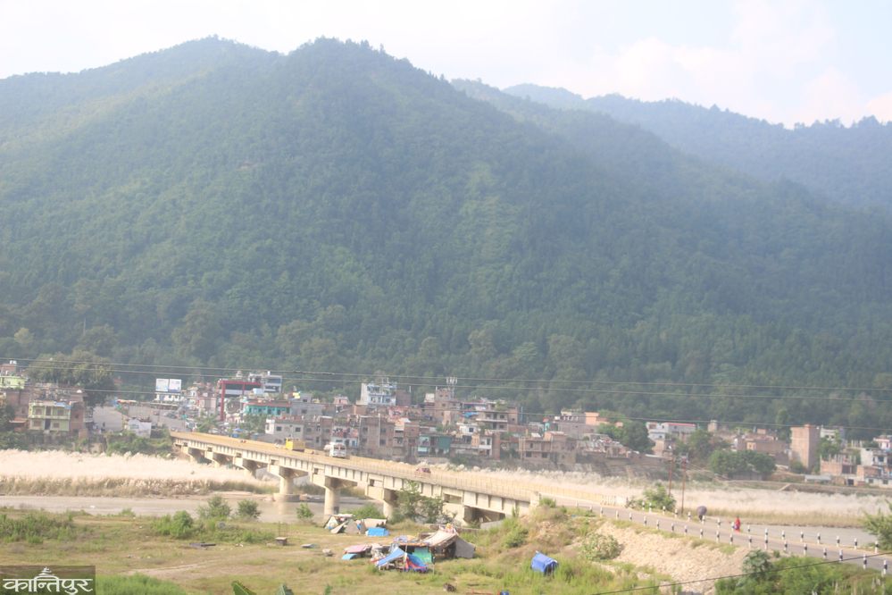
Dense settlements in areas such as Khaireni, Charange, Bhawanipur, Sheetalnagar, Madangram, Keuli, Sarantari, Satakkhola and others in Devdaha Municipality are on unclaimed land. There are settlements in the Ailani and Chure areas to the north of the highway. Spread over 136 square kilometers, 40 percent of Devdaha's land is forest and Chure. The process of encroaching on the river banks, forests, and the foothills of Chure and establishing settlements is still ongoing.
The Forest Consolidation Project had started clearing forests and establishing settlements here since 2039 BS. Devdaha leader Siddhicharan Bhattarai, who is studying the issue of forest areas and unorganized settlements, said that the northern area of the highway is being filled with unorganized settlements. 'There is no alternative to managing it,' he said, 'The government should protect the open land by organizing the settlements.'
A city has been built in Sainamaina Municipality of Rupandehi based on the foothills of Chure. More than 45 percent of the settlements here are in the foothills of Ailani and Chure. Settlements began in Sainamaina 62 years ago. The population density in Murgiya Bazaar under wards 3 and 4 of Sainamaina has been increasing rapidly since 2040 BS.
Every year, 6 to 700 new houses are added in the Ailani. Markets such as Murgiya, Parroha, Jharbaira, Dudhraksha, Sorauli, Kalauni, Saljhandi are under the Ailani.
Rambali Chaudhary, a people's representative from the panchayat to the multi-party system, said that 45 percent of the households in the Sainamaina market area still do not have land ownership certificates. At Chaudhary's initiative, the then King Birendra had helped build a government structure by making Murgiya the center in 2040 BS. Development had begun in Murgiya and its surroundings since then. 'A settlement has been developed in the Ailani area of about 100 bighas of this area,' he said. 'Now that the land is gone, the foothills of Chure are being encroached upon.' He said that the government is forced to distribute certificates even after cutting down forest areas.
A large settlement has been developed in the Tinau River Ukas area in Butwal-11. The locals call the settlement 'sukumbasi city'. Tinau has dense settlements including Devinagar, Buddhanagar, Majuwa, Sundarnagar. The state has provided all facilities there too. The municipality collects revenue by approving house maps. However, no one has land ownership papers. Large buildings and infrastructure have been constructed in the name of ‘sukumbasi’.
‘There are people who are living on Tinau land even after renting houses available in the market,’ said a local from Butwal-11, ‘There are many who are living on public land, educating their children, sending them abroad and paying rent for their houses.’ Locals say that the party had previously developed the settlement as a vote bank. Therefore, they say that it is difficult to remove encroachers from Tinau. Most of the Ailani and Chure areas of Rupandehi are encroached lands in the name of Ukhada, Sukumbasi, Block No. 8, forest areas, and river development.
According to Kumar Thapa, Chairman of the Land Problem Resolution Commission Rupandehi, 76,646 Sukumbasi and unorganized settlers have been identified in various places in the district. The commission has classified such households as landless Dalits, landless squatters and unorganized settlers. ‘The largest number of unorganized settlers have been seen,’ said Thapa, ‘They have been living on open land and riverbed land.’
He said that the first phase of accurate data has been collected from all local levels in the district. There are 2,997 landless Dalits, 6,658 landless squatters and 66,400 unorganized settlers in all local levels of Rupandehi. According to the commission, the largest number of them is in Butwal sub-metropolitan city, where there are 333 landless Dalits, 943 landless squatters and 15,598 unorganized settlers. There are 325 landless Dalits, 404 landless squatters and 15,400 unorganized settlers in Sainamaina and 160 landless Dalits, 265 landless squatters and 13,605 unorganized settlers in Devdaha.
 People are living on unregistered land in Rampur Municipality of Palpa, Kaseni of Mathagadhi Rural Municipality, Damkada of Tansen Municipality, Phek of Ribdikot, and Prabhas of Tansen. Last year, land deeds were distributed in Bejhad, the main market of Rampur. Before that, 854 families there had been without land deeds for years. Last year, 702 families were distributed land deeds for the houses they lived in. Since 2035/36 BS, the school had sold land for the operation of Ramtulsi Secondary School in Rampur-5 and Daraithanti Secondary School in Ward No. 6.
After that, the former Rampur VDC also sold the land with party consent. Since then, the locals have been enjoying it.
High-ranking government officials and political party leaders had taken the initiative to make the land in the name of the school available to individuals. Before obtaining the title deeds, houses were built on public land. Mathagadhi-3 Kaseni Sarai is also an area with unorganized settlements. There, Divya Jyoti Mavi had planned and distributed land to those who helped run the school. The landowner has filed an application with the Sukumvasi Problem Resolution Commission demanding a title deed for the unorganized settlements. Land is bought and sold there on the basis of receipts.
There are 52 houses of squatters living in Panitanki, one kilometer south of Tansen Tundikhel. There are more than 400 people with Guthi problems in this area. Public land has also been encroached on in historical and religious areas. The land in this area has been in the grip of land mafia for the past 15 years.
The local administration has not been able to protect the land. Now everyone has come with various receipts and deeds and built houses. The land revenue department has stated that the government has reduced the land by about 70 ropanis (per piece of land) in the Prabhas area. Encroachment on public land has started after the opening of Lumbini Medical College and Teaching Hospital in this area.
Gyanmala Mavi located in Ribdikot Rural Municipality-8, Fek, sold public land in the form of 24 plots in 2050 BS. The school sold those plots because it did not have money to run Class 8. At that time, the school was unable to raise 50 thousand rupees, so it sold a 20-hat-frontage plot for 2/2 thousand. There are pine trees behind it. People have now built concrete buildings in those plots. Now there is a market.
Rampur Municipality of Palpa, Kaseni of Mathagadhi Rural Municipality, Damkada of Tansen Municipality, Fek of Ribdikot, and Ailani land in Prabhas of Tansen. There are 7,670 households in all 10 local levels of Palpa, including 6,678 unorganized households, 315 Dalit squatters, and 674 other squatters. In Rampur Municipality, there are 1,218 landless households, 65 Dalit squatters, and 71 other squatters. In Tansen Municipality, there are 1,227 landless households, 174 Dalit squatters, and 325 other squatters. In Purbakhola, there are 26 unorganized households, in Mathagadhi, there are 663 unorganized households, and 7 other squatters. In Tinau, there are 1,613 unorganized households, 45 Dalit squatters, and 245 other squatters.
In Rainadevi Chhahara, there are 1,063 unorganized households, 6 Dalit squatters, and 24 others, while in Baganaskali, there are 102 unorganized households, 10 Dalits, and 15 others. In Ribdikot, there are 62 unorganized families, 10 Dalits and 15 others, in Rambha, there are 27 unorganized families, 4 Dalits and 6 others, while in Nisdi, there are 680 unorganized families, 7 Dalits and 15 others. Of these, the process of 5,932 families with completed documents has been moved forward, the previous commission has stated.
Similarly, residents of two settlements in Thaha Municipality in Makawanpur are starting to feel the pain of having to leave their homes. Thaha-4 has been living in Simbhanjyang, Daman and Thaha-7 in Dandawas Bazaar for 50 years. Settlement began in Simbhanjyang and Daman during the construction of the Tribhuvan Highway. The residents who have been living in those settlements for more than 5 decades do not have land ownership papers in their names. They are living right next to the highway.
Lal Bahadur Bhujel of Simbhanjyang, who has been living there since his grandfather's time, said, "We have not only not received the land title deed, the government has repeatedly said that it will provide the land title deed after surveying, but it has not been given yet." Bhujel said that he was afraid because the Slum Dwellers Commission and the government did not provide the land title deed. "We have made Simbhanjyang and Daman a tourist destination, we have not encroached," he said. There are 100 households in Simbhanjyang and Daman.
Thaha-7 Dandawas is being developed as a tourist destination. Dandawas, located 10 kilometers from Shikharkot Bazaar, is an old market of the former Agra VDC. The market has been bustling for five decades. There is a blacktop road from the center of the market. Dandawas is a well-organized market without land title deed. There are more than a hundred pucca houses in Dandawas.
‘If the settlement is started to be evacuated in the name of encroachment, 50,000 houses in Makawanpur should be demolished,’ said Bishnu Bista, the head of Thaha Municipality. ‘Most of the residents of Chepang and Banakariya settlements in Makawanpur or Bakaiya and Bagmati rural municipalities are without land documents because the government did not provide them in time.’
The residents of two settlements in Thaha Municipality of Makawanpur are starting to feel the pain of having to leave the Thathalo. They have been living in Simbhanjyang, Daman of Thaha-4 and Dandawas Bazaar in Thaha-7 for 50 years. During the armed conflict, in 2061, Shriram Chaudhary migrated with his family from Satti in Kailali and came to Krishnasar area in Gulariya-2 of Bardiya. They are living there by building a hut. Similarly, Sukhlal Tharu’s family from the former Kachnapur has come to the settlement there. The returning Tharu of Gulariya-1 is living in Krishnasar area as of 2 Mangsir 2062. Not only these three families, but also the head of Krishnasar Conservation Committee Khairapur, which currently has 142 households in Krishnasar area, said Bhojraj Pant. ‘79 bighas, 1 katta, 1 dhur of land in this area has been encroached,’ he said, ‘In 2015, the government gave compensation for 245 bighas of land and removed the settlements, but some families are still living in the conservation area.’ Although 93 households have received the compensation amount, many are still living here.
The government had provided compensation to relocate the Numbari landowners who were living in this area in 2028 to protect the Krishnasar. Since 2062/63, they have also come from Jumla, Kalikot and other districts to live here. The residents are in fear that they are being removed now. Local Savitri Tharu said that if the government removes them from here, they will be in trouble as they do not have land in their name. Krishnasar Conservation Area Committee Chairman Dipendra Yadav said that the people who have been living in the conservation area by handing over their ancestral homes to relatives from various places and building tents said that the government should investigate and manage the actual squatters.
Division Forest Office Chief Vijay Raj Subedi has announced that encroachments will be cleared by publishing a 15-day notice on April 14. He said that after removing encroachments in Kothiyaghat, Machad and Orali Bazaar in the district in the first phase, it will gradually start elsewhere as well. The forest department has stated that 27 houses will be removed in Kothiyaghat, 42 in Machad and 19 in Orali Bazaar.
There are records of encroachments in 63 community forests under the office. According to the old data under the forest office, the Division Forest Office has stated that 258 community forests have been encroached. Although there is a data of encroachment of 290.98 hectares of forest area, forest employees say that there is more encroachment than this. Division Chief Subedi stated that at least 1,000 hectares more forest area has been encroached despite the old data.
 What is public land?
Public land refers to vacant or public land that the government does not own. Such land is found in many districts in every district. In the Terai districts, the lands along the river banks, near forests, roads, rivers, lakes, ponds, cliffs and other places and their vicinity are commonly called public, public and abandoned land, said Gyannath Dhakal, chief of the Land Revenue Office, Butwal. ‘Public land is understood to be land that is not owned or owned by anyone but is under the protection of the government,’ he said, ‘especially land that does not have a land title deed or record in the name of the government is public.’
Assistant Chief District Officer of Rupandehi, Meghnath Upadhyay, said that the cost of such lands and settlements is also being collected. ‘We are currently collecting details of public, public and abandoned lands with the help of local levels and government offices,’ he said, ‘Conservation work will begin after the study.’
According to the Land Revenue Act 2034, ‘government land’ means land on which roads, paths, railways, and government houses, buildings, or offices are located. Similarly, the Act defines forest, buten, jungle, river, stream, riverbed, lake, pond, and its banks, canal, ditch, cliff, cliff, and mountain land as public or private land.