The Supreme Court's order to remove hotels, houses, government and private structures within 65 meters of Fewa Lake is being implemented, and compensation and legal disputes are increasing.
We use Google Cloud Translation Services. Google requires we provide the following disclaimer relating to use of this service:
This service may contain translations powered by Google. Google disclaims all warranties related to the translations, expressed or implied, including any warranties of accuracy, reliability, and any implied warranties of merchantability, fitness for a particular purpose, and noninfringement.
After the issue of Fewa Lake conservation was included in the government's 100 agenda of governance reforms, Prime Minister Balendra Shah called Pokhara Metropolitan Mayor Dhanraj Acharya on Sunday. He understood the progress report on removing encroachments on Fewa Lake. Acharya briefly informed about the work done so far. Prime Minister Shah suggested working in collaboration with the Tourism Minister.
Point number 76 of the 100 agenda made public by the Balendra-led government states that 'the watershed in Fewa protected area in Pokhara will be effectively protected by removing encroachments and restoring, landslide management, source protection and climate change adaptation works within three months with the participation of stakeholders'.
Minister for Culture, Tourism and Civil Aviation Khadakraj Poudel (Ganes) was elected from Constituency No. 1 of Kaski. When Acharya was elected as the Metropolitan Mayor in 2079, Poudel was also an independent candidate with the baton election symbol. Balendra won the election in Kathmandu, Poudel got 3,000 votes in Pokhara.
The issue of Fewa Lake conservation has regained attention after it was included in the government's 100 agenda. Repeated court rulings paved the way for Fewa Lake conservation. The Supreme Court's ruling has provided guidelines to prevent encroachment and prevent it from being filled. However, the pace of implementation as per the ruling is slow. The Supreme Court's repeated rulings on Fewa Lake conservation and the previous efforts should be examined to understand the status of the implementation of the mandate.
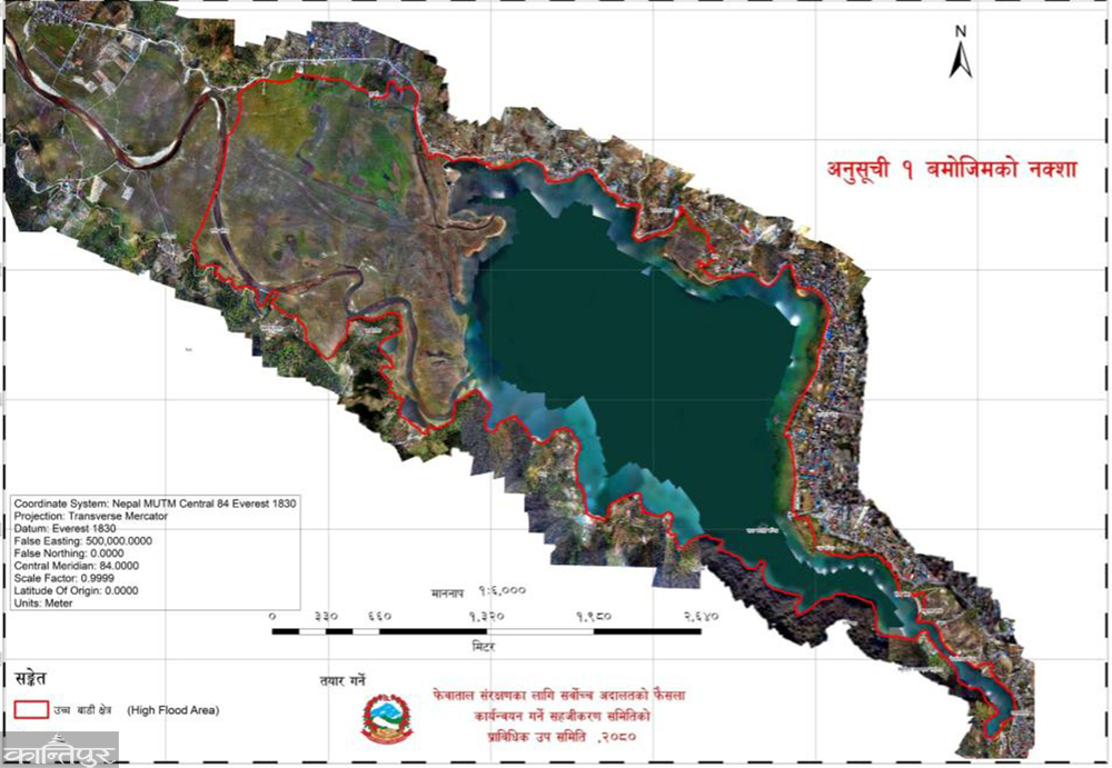
The current form of Fewa Lake, which originated from geographical changes at different times, seems to have been formed after 2018. In 2018, the Nepal-India Cooperation Mission dammed the eastern bank of the lake. In 2018, a compensation policy was introduced. The pillar of the dam mentions that the area of the lake was 4 square miles (10.36 square km) at that time in 2018. But no basis has been found to substantiate the claim.
The Pokhara City Plan was approved by the Council of Ministers on 15 Mangsir 030 in accordance with the City Planning Implementation Act, 2029. On 17 Mangsir 030, it was decided in the Nepal Gazette to keep Fewa Lake as a protected area and not allow any construction work up to at least 200 feet (60.69 meters) from the shore of the lake. By 031, the issue of compensation for the land occupied by the lake had been resolved.
The Fewa Dam collapsed in 031. When the dam collapsed, the lake was half empty. The land at the head of the lake was left by water. A swamp formed. The locals started farming. In 032, the central survey team arrived. In 033/34, many people registered their land on the basis of farming. In 034, the foundation stone of another dam was laid a little lower than the first one and the construction was completed in 038. After the dam was built, the water started to take its place again. The land on the banks was submerged by water. In 038, the study report of the Government of Nepal and UNDP stated that the area of Fewa Lake is 5.8 square km.
It seems that the decision was taken in the 15th meeting of the Kaski District Council held on 15 Ashad 064 to prevent any physical structure from being built within 65 meters of the lake's shore for the protection of the lake. The meeting of 28 Shrawan 064 had made the sole decision to keep a 65-meter buffer zone (intermediate area) around Fewa Lake.
After seeing that the decision was not implemented and encroachment on the lake increased, advocates Khagendra Subedi and Ramesh Ghimire filed a writ petition in the Supreme Court on 10 Magh 2067, making the then 16 different bodies, including the Office of the Prime Minister and the Council of Ministers, the defendants in the matter of Fewa Lake conservation. The then Prime Minister Baburam Bhattarai formed a committee under the leadership of Pokhara Valley Urban Development Committee Chairman Bishwaprakash Lamichhane to investigate the encroached land of Fewa Lake. The committee submitted its report on 3 Jestha 2069.
According to Lamichhane's report, a person has created 1,692 ropanis of lake land on the western side of the lake in his name. The report states that after the central survey of 032 came when the water level decreased by half due to the collapse of the dam, the locals influenced the survey office and registered the land in 033/34. The report mentions that the survey map of the then Chapakot 1, Pandeli 3 and 5 wards had been divided into sections measuring 150 to 750 meters long and 5 to 8 meters wide. Out of the 500 ropanis of land registered after the lake took shape by the time the dam was built in 041, 1692 ropanis of land is still under water.
The Lamichhane report suggested that the land deeds of the 1,692 ropanis of land in the names of 950 people should be cancelled. According to the tracing map of the survey office 093-0875, the demarcation of those lands is not visible. The report states that the area of the lake is 6.5 square kilometers.
Based on Lamichhane's report, on 16 Baisakh 075, a joint bench of Supreme Court Justices Om Prakash Mishra and Sapana Pradhan Malla had issued a decree on 11 different issues in the name of the opposition body. The verdict is considered historic in terms of Fewa Lake conservation. The order included instructions to establish the four forts of Fewa Lake within 6 months, remove structures within 65 meters within 6 months, acquire the surrounding land for long-term conservation of the lake with compensation if necessary, and control the Gegran flowing from the source.
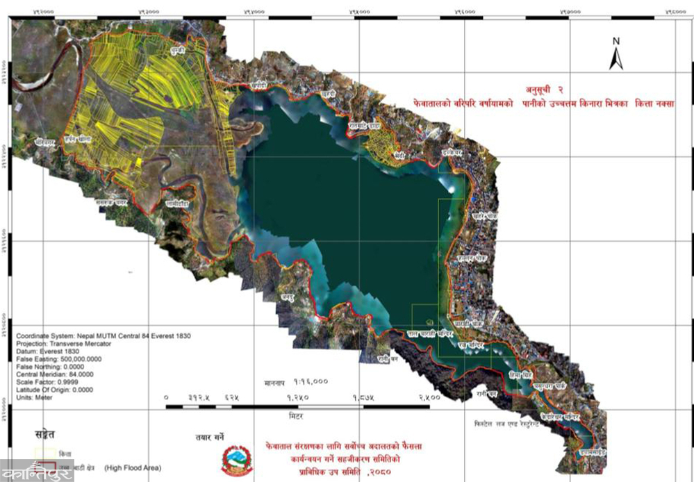
After the verdict was not implemented for a long time, advocate Subedi filed a contempt of court case in the name of the defendant. In 2077, the then Prime Minister KP Sharma Oli formed a committee to determine the four forts of Fewa Lake, demarcation and mapping under the chairmanship of Kaski UML leader Punya Poudel. There are two different reports on the contaminated land, one by the committee led by Bishwo Prakash Lamichhane and the other by the committee led by Punya Poudel.
The committee led by Poudel submitted its report to the government in 2077 Falgun. According to the report, the area of Fewa Lake was fixed at 5.726 square km (11255 ropani) and published in the Gazette.
During the time of the then Metropolitan Mayor Man Bahadur GC, the 55th executive meeting of 16 Chaitra 078 decided to set the standard of Fewa Lake at 30 meters. The meeting had set the standard of Rupatal and Begnastal at 55/55 meters, and of Khaste, Dipang, Maidi, Nyureni Gunde, and Kamal Pokhari lakes at 20/20 meters.
Advocates Khagendra Subedi, Sarojnath Pyakurel, Krishnahari Khadka, and Dipendra Prasad Ghimire had filed a writ petition in the Supreme Court on 11 Jestha 079 demanding the cancellation of the decision and the removal of illegal structures built in the watershed area. In that writ, the full text of the decision of the joint bench of Justices Kumar Regmi and Hari Prasad Phuyal on 4 Ashad 080 was published on 9 Asoj. After the full text came, the knot of removing unauthorized structures was loosened by considering the 65 meters from the lake shore as the intermediate zone. It was directed to make the 65-meter area a green area.
After that verdict, the way was opened to cancel the registration of the land registered in the name of the individual after the survey of 032/33 in Fewa Lake and bring it in the name of the lake. The full text of the verdict explained that the registration of the contaminated registered land will be automatically canceled. The Supreme Court had also ordered to implement the standard of 65 meters from the lake shore within 6 months. The full text of the verdict states that while implementing 65 meters, compensation should be given only for the land registered before the survey of 032/33 BS.
The full text states that houses, buildings, businesses, hotels, restaurants, resorts, etc. and all other types of personal, government or public physical structures located within 65 meters from the highest water level of the rainy season around Fewa Lake should be removed and vacated within 6 months and the said 65-meter intermediate area should be declared as a complete green area and maintained.
Since there is no dispute regarding compensation for the land of Fewa Lake that existed from 018 to 031 and even if there was, it should be considered to have been settled immediately, it has been explained that the land of the lake and its settlement are government land of the Government of Nepal. The full text states, ‘Since the Land Revenue Act 034 provides that government and public land should not be registered or cultivated and that cultivation will automatically be void, the order of the registration officer prepared to the contrary shall be void.’
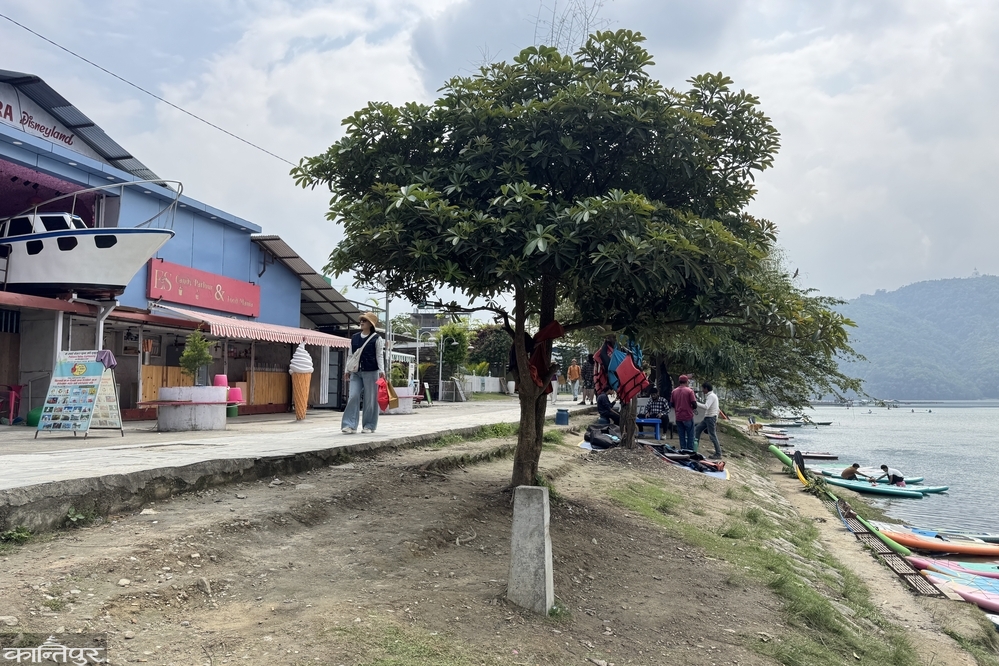
In the case of land of the lake from 018, except for the land of Ailani, Parti or other types of public land, the previous registration, Shrestha, Tiro, continuous use before the survey of 032/33, compensation should be paid as per the law for 65 meters from the edge of the highest water point of Fewa Lake during the rainy season.
On 13 Mangsir 080, a facilitation committee was formed under the coordination of Gandaki Province Chief Minister Surendra Raj Pandey to implement the Supreme Court's decision for the protection of Fewa Lake.
The members of the facilitation committee are the Mayor of Pokhara Metropolitan City, Chief Secretary of Gandaki Province, Region President of Nepal Army West Region, Province Attorney General, Chief District Officer of Kaski, Chief Administrative Officer of the Metropolitan City, Gandaki Province Police Chief, Armed Police Muktinath Brigade President, National Investigation Director, and Executive Director of the Province Lake Authority. The Chief Administrative Officer of Pokhara Metropolitan City has been appointed as the member-secretary of the committee. The Provincial Lake Authority has now been abolished. On 15 Magh 080, the facilitation committee formed a technical subcommittee under the coordination of Gangalal Pokhrel, Chief Surveyor of the Ministry of Land Management, Agriculture and Cooperatives of the province. The subcommittee included the head of the survey office, an officer of the Land Revenue Office, an engineer of the Irrigation Division Office and a surveyor of Pokhara Metropolitan City. The technical subcommittee was responsible for determining the highest water level of the lake and determining an area 65 meters above that level. On 6 Jestha 082, the subcommittee submitted its report to the facilitation committee. According to the study of the subcommittee, the lake area is 6.343 square kilometers (12,468 ropani 3 paisa 3 daam). This is the area of the highest water edge identified during heavy rains in Pokhara on 12 Ashar 081.
The area made public by the facilitation committee is 617 square kilometers (1,213 ropanis) more than the last area published in the gazette. Pokharel, the ministry's chief surveyor, said that the area of the lake was determined through DGPS technology and drone survey. According to him, the subcommittee has taken the highest water level at the dam site as 794.7 meters above sea level as the basis.
Based on the subcommittee's recommendation, the facilitation committee started burying poles on the lake shore from 17 Jestha. Although the subcommittee digitally determined 1,055 points, 611 poles were buried around the lake due to geographical disparities, said Prakash Subedi, the office chief of the Pokhara Valley City Development Committee. The area up to 65 meters from the boundary where the poles were buried has been maintained at 1.268 square kilometers (2,491 ropanis 7 anas 1 paisa 2 daam).
The Supreme Court has stated that the land within the high water table will be deemed contaminated and automatically cancelled. In this way, Pokhara Metropolitan City Mayor Dhanraj Acharya says that the registration of land within the area where the pole is currently installed will automatically be cancelled. According to him, there are about 4,800 plots of land within 65 meters. Of these, the work of separating the public, contaminated and land of people who were registered before 032 BS and who were required to pay compensation is still pending.
‘The facilitation committee had already given the task to the sub-committee to separate the contaminated and compensation-paying land within 65 meters after the pole was installed,’ he said, ‘The work had already started. The Gen-G movement burned all the documents. There was a delay in the work.’ The Pokhara Valley Urban Development Committee building, which houses the secretariat of the technical sub-committee, was burned in the Gen-G movement. The Cooperative Development Committee met on 3 Chaitra and gave the subcommittee two months to confirm the details of the land within 65 meters.
After the Prime Minister showed interest, Metropolitan Mayor Acharya said that he drew attention to the issue of compensation for individual land. ‘First, the technical subcommittee should decide how much land within 65 meters should be compensated and how much should not be compensated, and then we will send a report,’ he said, ‘We are removing structures built on public land, in the case of individuals, we need to go through the process. The government should also arrange a budget to provide compensation. This cannot be done within 100 days.’
He mentioned that a decision will be made about the structures within it only after the land to be compensated for bringing the land within 65 meters into the name of the lake is confirmed. ‘लालपूर्जा भएका जग्गाको मुआब्जा दिने विषयमा सर्वोच्चले नै भनेको छ, त्यसभित्र भएका संरचनाको हकमा नीतिगत निर्णय हुनुपर्छ,’ उनी भन्छन्, ‘यद्यपि, ६५ मिटर भित्र कुनै पनि संरचना बनाउन अनुमति लिएका छैनन् । नक्सापास पनि भएको छैन ।’
६५ मिटरभित्र पर्ने सरकारी संरचना पनि हटाइने र त्यसको सुरुआत ड्यामसाइडमा रहेको महानगर मातहतहै शिक्षा महाशाखाको भवनबाट हुने उनले सुनाए । ६५ मिटरभित्रै पर्ने प्रहरी गण, नेपाल पर्यटन बोर्डको भवन लगायत सरकारी संरचना भत्काउनुपर्ने उनले सुनाए । ‘फिस्टेल रिसोर्टको विषयमा म बोल्न चाहिनँ,’ उनले भने, ‘रत्न मन्दिर र हिमागृहलाई संरक्षित क्षेत्रभित्र राखिन्छ ।’
लेकसाइडकै रत्न मन्दिरदेखि फिस्टेल गेटसम्मका स्थानीयले सर्वोच्चको फैसला कार्यान्वयन रोक्न माग गर्दै २१ वैशाख ०८१ मा सर्वोच्च अदालतमा रिट दायर गरे । बुधराज भुजेलसहित २२ जनाले सार्वजनिक सरोकारको रिट दर्ता गरेका थिए । उनीहरुले त्यस क्षेत्रको जग्गामा परापूर्वकालदेखि तिरोभरो तिरेर आफ्ना पुस्ता बस्दै आएको र नक्सा पास गरी घर र होटल निर्माण गरेको आफूहरुको सम्पत्तिको हक अन्तर्गत रिट दायर गरेको बताएका छन् । उक्त रिटमा सर्वोच्चले २३ वैशाखमा सुनुवाई गर्दै अन्तरिम आदेश जारी गर्न अस्वीकार गर्यो ।
तर अन्तरिम आदेशका लागि दुवै पक्षलाई छलफलमा बोलाउँदै कारण देखाऊ आदेश जारी गरेको थियो । उक्त आदेशमा दुवै पक्षले लिखित जवाफ बुझाइसकेका छन् । मुद्दाको पेशी सरिरहेको छ । मुद्दाको प्रक्रिया चलिरहेकोले हिमागृहदेखि रत्नमन्दिरसमम महानगरले समेत पोल गाडेको छैन ।
निवेदक एवं लेकसाइडको गौरीघाटका पर्यटन व्यवसायी सूर्य भुजेलले विश्वप्रकाश लामिछानेको प्रतिवेदन अनुसार हुनुपर्नेमा त्यसभन्दा अघि बढेर सर्वोच्च अदालतबाट फैसला भएकोले रिट दायर गर्नुपरेको बताए ।
‘प्रतिवेदनमा रत्न मन्दिरदेखि फिस्टेल गेटसम्मको हकमा तालको किनाराबाट ३० मिटर संरक्षित क्षेत्र कायम गर्न उपयुक्त हुने भनि सुझाव दिइएको छ,’ उनले भने, ‘सर्वोच्चले मुआब्जा दिएर हटाउनु भन्यो तर सरकारले दिने मुआब्जा चलनचल्तीभन्दा निकै कम हुन्छ । अर्बौ मुआब्जा दिएर ठुल्ठूला होटल भत्काएर सरकारले गर्ने के हो भन्ने पनि कुनै योजना छैन ।’
महानगरसँग हाल ६५ मिटरभित्र व्यक्तिका जग्गाको कति मुआब्जा दिनुपर्छ भन्ने तथ्यांक छैन । यसअघि मानबहादुर जीसीको पालामा ०७६ मा महानगरपालिकाले नापी कार्यालय कास्कीको सहयोगमा विस्तृत अध्ययन गरेको थियो । उक्त अध्ययन प्रतिवेदनमा ३० मिटर, ३५ मिटर र ६५ मिटर मापदण्ड लागु गर्दा सरकारलाई पर्ने व्ययभारको विश्लेषण गरिएको छ ।
६५ मिटर मापदण्ड कायम गर्दा झण्डै ५ सयवटा पक्की संरचना पर्ने देखिन्छ । विश्वप्रकाश लामिछानेको प्रतिवेदनले सुझाएअनुसारको तालवरिपरि ६५ मिटर जग्गा लिँदा झण्डै एक हजार रोपनी व्यक्तिको जग्गा पर्छ । अध्ययन टोलीले उक्त जग्गाको मालपोतको मूल्यांकन अनुसार १० अर्ब रुपैयाँ जति मुआब्जा दिनुपर्ने भनेको छ । चलनचल्तीको दरअनुसार दिँदा ४० अर्ब रुपैयाँभन्दा बढी पर्ने भनेको हो ।
वन मन्त्रालयले सन् २०१४ मा गरेको अध्ययन प्रतिवेदनअनुसार फेवा जलाधारका आठ उपजलाधारबाट हर्पन खोला उपत्यकामा जम्मा भएको थिग्रेनीको परिमाण झण्डै २७ लाख ८४ हजार घनमिटर थियो । फेवा जलाधारको भू–उपयोगबाट वार्षिक १ लाख २९ हजार ४ सय ९० घनमिटर भू–क्षय हुन्छ ।
तत्कालीन जिल्ला भू–संरक्षण कार्यालय कास्कीको अध्ययन अनुसार वार्षिक भू–क्षय १ लाख ७५ हजार देखि २ लाख २५ हजार घनमिटरसम्म हुन्छ । उक्त अध्ययनले अध्ययनले १९ उपजलाधार क्षेत्रबाट वार्षिक रुपमा १ लाख ४२ हजार ३ सय ५९ टन माटो बगाएको देखाउँछ । सन् १९९० देखि १९९४ सम्मको मापन गर्दा वार्षिक १ लाख ७५ हजार देखि २ लाख २५ हजार घनमिटर गेग्रान थुप्रिएको छ । १७.३७ घनमिटर माटो प्रति हेक्टर प्रति वर्ष फेवा जलाधार क्षेत्रबाट भू–क्षय भएको पाइन्छ ।
कार्यालयले प्राकृतिक रुपले फेवाताल पुरिने क्रम नरोकिने हो भने ७५ देखि १ सय वर्ष बीचमा ताल लोप हुन सक्ने खतरा औंल्याएको थियो । फेवातालको गहिराइ समेत घटिरहेको छ । पोखरा महानगरपालिकाले फेवाताल पुरिनबाट जोगाउन हर्पन खोला, अँधेरी खोलामा ५ वटा सिल्टेसन चेक ड्याम बनाएको छ । उक्त ड्यामले खोलाबाट बगेर आउने गेग्र्यानलाई रोक्ने काम गर्छ ।