Kot means ‘hill’. During the Baise kingdom of western Nepal, these hills were administrative centers and battle forts. Nearly two dozen forts in Karnali, including Jajarkot, Kalikot, Musikot, Simkot, Gotamkot, Aathbiskot, and Jaharikot, hold historical significance.
We use Google Cloud Translation Services. Google requires we provide the following disclaimer relating to use of this service:
This service may contain translations powered by Google. Google disclaims all warranties related to the translations, expressed or implied, including any warranties of accuracy, reliability, and any implied warranties of merchantability, fitness for a particular purpose, and noninfringement.
In the 15th century, the then King of Jumla, Medini Barma, entrusted the Rukum Kingdom (Jumli Khalanga) to his younger brother Pitambar. One day, a boar went missing from the court of the Chaukhabangi King. The king's maidservant named 'Mushi' reached a hill while searching for the boar.
She pleaded with the king that since the hill was visible from all sides, it was more habitable than Chaukhabang. At her request, the king built a palace and started ruling the kingdom from there. That place was named Musikot after the palace's steward 'Musi'.
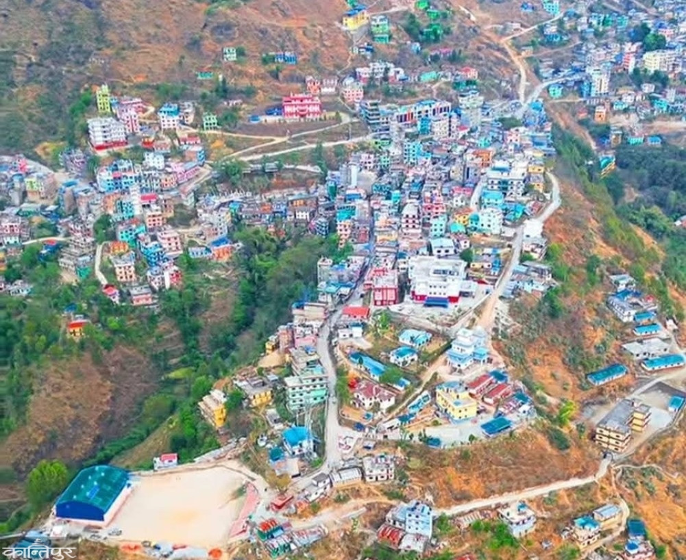
Mahendra KC, the head of Musikot Municipality, says that the district headquarters of Rukum West was named after that name. According to him, the place where the then king ruled has been turned into a tourist destination by building a temple, park and other structures. From where most of the villages of the district can be seen, he says.
In the local Kham language, Musikot means Mhosiv (hidden mound). In the medieval period, there were twenty-two kingdoms around Musikot: Rukumkot, Banfikot, Gotamkot and Jaharikot. In 2030, the district headquarters of Rukum was shifted from Rukumkot to Musikot. According to the National Census-2078, Musikot, with a population of 34,270, is divided into 14 wards. Musikot is inhabited by all castes.
Another state located in western Rukum is Gotamkot. The founder of Gotam state, which is under the Baise state, is Rukume Raja Dare Jaitam's son, Prince Setu Bam. He received this state as a part of his kingdom in 1600 BS. It is now in Aathbiskot Municipality-5 and 6.
'The borders of this state were connected to Jumla state, Aathbiskot state and Banfi state,' Ward No. 6 Chairman Dhaneshwor Sharma said, ‘This state was integrated into the Kingdom of Nepal during the reign of King Motimardan Shahi in 1843 BS.’ According to the National Census-2078, Gotamkot, which has about 1,300 households, has a population of 7,040. Gotamkot is also considered the origin of the ‘Gautams’, said Ward Chairman Sharma.
According to historians, at one time, the Khas established a powerful kingdom with the Karnali region as its center. Later, it broke up and was divided into 22 kingdoms. One of those kingdoms was established by King Jagati Singh around 1300 BC with Jajarkot as its center. According to local leader Vasudev Sharma, at that time, the Jajarkot kingdom extended to the Ganges River through Dailekh, Jumla, Kalikot.
‘Because of this power, Prithvi Narayan Shah had agreed not to attack Jajarkot during his unification. The sword that Jajarkot received in the agreement with Prithvi Narayan Shah is still worshipped on the day of Dashain flower festival,’ he said. ‘During Bahadur Shah’s time, some western lands were incorporated into Nepal in cooperation with Jajarkot in accordance with the agreement with Prithvi Narayan Shah. As the power of the Gorkhali kings increased, the Mustangi, Salyani, Bajhangi and Jajarkoti kings each gave their ‘Shri’. There is a history of the Shah dynasty king receiving the title of Shree 5 because he was the overlord of these four kings.’
At that time, the drinking water project and the bridge over the Bheri River built by Chandrashamsher’s younger queen Balkumari of Jajarkote at the request of the British are still in operation.
After the Nepali Congress won two-thirds of the vote in the 2015 BS general election, the parliament introduced a bill to abolish Raja Rajouta. At that time, the Jajarkoti Raja Prakash Bikram Shah and three other kings of the country were given allowances and the lands were officially incorporated into Nepal, says another local leader, Khambajung Shah.
According to him, even though the parliament took away the king's rights, Prakash Bikram Shah ruled as a local king in the Khalanga palace until the middle of the Panchayat period. 'But due to internal reasons, there was gradually discord in the Thakuri family,' he said. 'After that, Prakash Bikram sold the palace to the government for one hundred thousand rupees and started living in Kathmandu, since then Jajarkot has been completely stateless.'
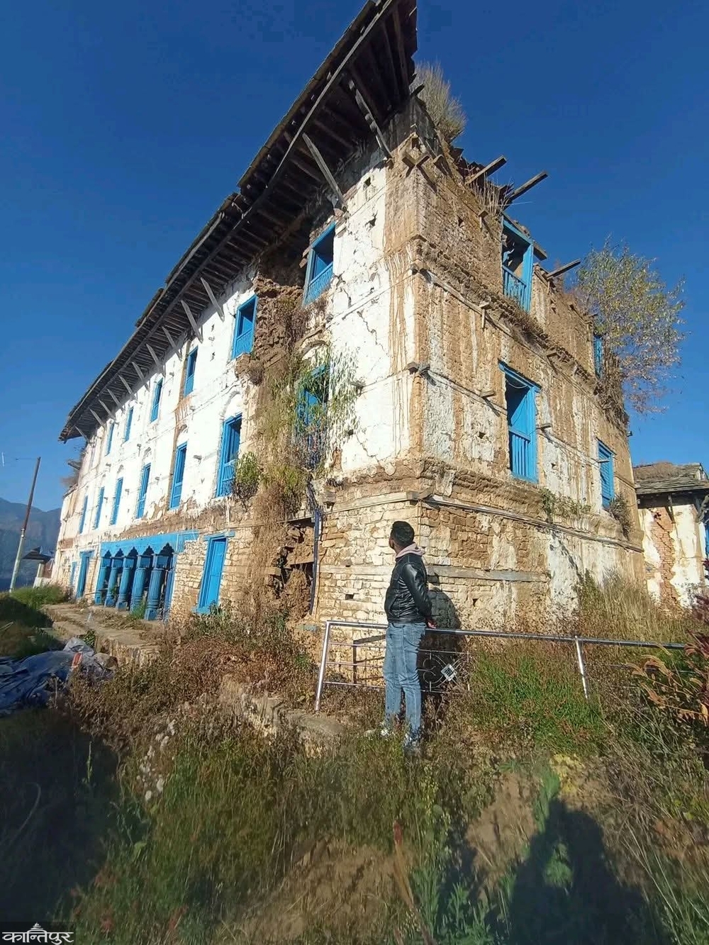
Another leader, Janak KC, says that there is a popular rumor that the name Jajarkot was a corruption of the word 'Jharkot'. The earthquake that hit Jajarkot in 2080 damaged many palaces in the area. The damaged palaces have become ruins due to lack of timely reconstruction. He complains that the palaces that were once run by a powerful kingdom under the Baise kingdom in western Nepal are now under the umbrella of tarpaulins.
‘Earlier, this place was called Jajarkot instead of Jharkot because there was thick jungle all around and a hill like a fort in the middle,’ he said. ‘There was once a powerful kingdom here, but after the 2080 earthquake, half a dozen palaces and other structures have become ruins. It is necessary to reconstruct them and preserve the archaeological structures.’
In the 15th century (during the Baise-Chaubise kingdom), the then Bhure-Takure kings had started building their palaces on high peaks (forts and forts) to protect themselves from various attacks. According to Ramananda Acharya, who has done various research on the history of Karnali, the meaning of Kot is ‘hill’.
During the twenty-second reign of western Nepal, these hills were administrative centers and battle forts. He said that about two dozen Kots in Karnali hold historical importance. Another Kot of Karnali is Kalikot. In 2032 BS, Tibrikot VDC of Jumla district was divided and Kalikot was formed. Kalikot is known as the youngest district of Nepal.
Initially, the district headquarters was established in Manma village of the former Manma VDC-3, and since 2040 BS, the district headquarters has been established at Khandachakra hill in the same VDC, said local leader Chitra Singh. According to him, Kalikot was named after Kalika Bhagwati located in Mugraha of Shubhakalika Rural Municipality.
‘This place is located at a high place like the Kot Durbar of the Bhuretakure kings, so it became Kalikot,’ he said, ‘It had been a separate district from Jumla since 2032.’ Kalikot, which has 33 VDCs, Sappata, Jukot and Bai VDCs were merged with Bajura district in 2038.
‘Simmkot’, which is located at an altitude of about 3,000 meters, is also the district headquarters of Humla. According to the National Census-2078, Simkot Rural Municipality, which has 6,632 households, is divided into 8 wards and has a population of about 15,500. Simkot is currently known as the gateway to Mansarovar-Kailash. ‘Sim and Kot (mountain) are combined to form Simkot,’ says local leader Vijay Lama. ‘It has become the gateway to Mansarovar-Kailash, from where nearly 10,000 tourists visit Kailash every year.’