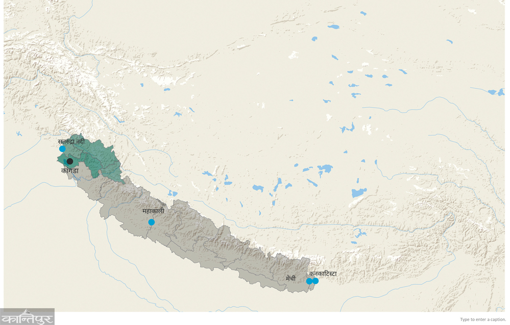
In 280 years, the borders of the land now known as 'Nepal' have changed many times. Today, living between Mechi in the east, Mahakali in the west, and the interior mountains in the north, from the Jange Pillar in the south, our ancestors lived in 53 countries 280 years ago.
We use Google Cloud Translation Services. Google requires we provide the following disclaimer relating to use of this service:
This service may contain translations powered by Google. Google disclaims all warranties related to the translations, expressed or implied, including any warranties of accuracy, reliability, and any implied warranties of merchantability, fitness for a particular purpose, and noninfringement.
Here and there beyond Dasgaja bordering India, across and across the Mahakali, across and across the Mechi and across and across the Himalayas, we live the same people. People living on both sides share the same language and religion. Culture also matches.
Due to the lower part of the eastern border and the rivers and mountains in the west and north, the flow of people is a little less. To the south, it is difficult to distinguish which is Nepal and which is India.
But, we consider Warika as a relative and Parika as a stranger. We will not allow Parika to vote here. Because we are bound by borders. We are guided by boundaries. An artificial line has created a great divide between us.
In the past 280 years, the borders of the land that is now known as Nepal have changed many times. Today, our ancestors who live between Mechi in the east, Mahakali in the west, and Inner Himalayas in the north and Jange Pilar in the south lived in 53 countries 280 years ago. Our ancestors who were scattered in twenty-two countries could not say that Mount Everest is in my country. However, our ancestors did not have the knowledge that Everest is the highest peak at that time. No human ancestors in the world had it.
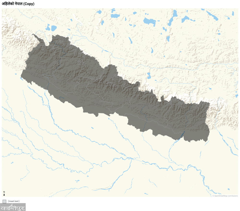 present-day Nepal .
Our ancestors scattered in twenty-two countries could not even be proud that Buddha was born in my country. Only one country could boast that. Did they not know that Buddha was born in their country? Or did he know then and later forgot?
If there were as many as 280 years ago or 53 countries in the area covered by Nepal today, would the state of different languages, religions and costumes be the same as it is now?
What would the governance system be like?
Prithvi Narayan Shah left his country Gorkha in 1801 and won Mahamandal i.e. Nuwakot. In the following seventy-one years, the map of present-day Nepal and the borders to the west changed. Many former countries were merged into one country.
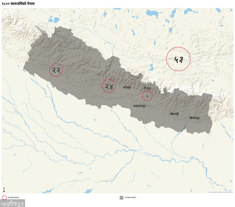 vs. In 1800, the then states of Nepal .
What happened to the 60 kings, their families, bardars, chiefs and subbas of those countries from the Tista River in the east to the Sutlej in the west?
and Raiti's condition?
What happened to the economy?
One can only guess about these matters. If that border had been maintained, one thing could be said for sure now. That is - when we had to go to Darjeeling, we did not have to reach another country.
Darjeeling is not a place worth visiting by many people like it is now, was it just like one of the mountains in the lake of West Elam? Darjeeling would definitely not have a free train. That place was not even a center of education.
We didn't have to go to other countries to go to places like Haridwar, Kedarnath, Badrinath in the west. When we went to Kala Pahad for work, we would be in our own country. There was no dispute over the Chuchche map like it is now. Because before the spread of the Chukche map, Nepal would have been far to the west.
Kanchenjunga is now on the border of Nepal and India. At that time it was only in part of Nepal. There was no mountain higher than 8,000 meters in India, that is, if the same border was maintained, India could not boast of having a peak higher than 8,000 meters in its country.
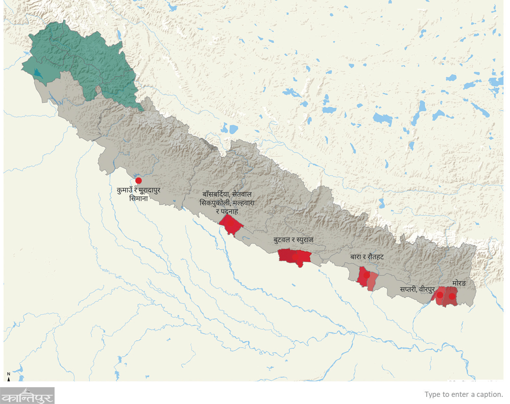
However, the spread of Nepal's borders lasted only for a while. Soon there was a border dispute with the East India Company, which was expanding into Hindustan. The British said that Padanah Gadhi of Bardia and five surrounding taluks were destroyed by Nepal. The British said that Malhwara and Padnah had been captured recently. He said that if these two taluks are handed over to the British, the other three taluks, which were "broken" a while ago, will be left to Nepal.
 vs. Nepal until the start of the war with the British in 1871.
Kachorwa and Simraungadh in Bara also had border disputes. The British said that the Nepalese destroyed 22 mauzas of Rautahat. The crops of border farmers were looted.
In the east, the river Koshi flowed further east than it does now. At that time, there was a border dispute in Birpur, west of Koshi. And before Koshi, there was a land dispute in Morang too.
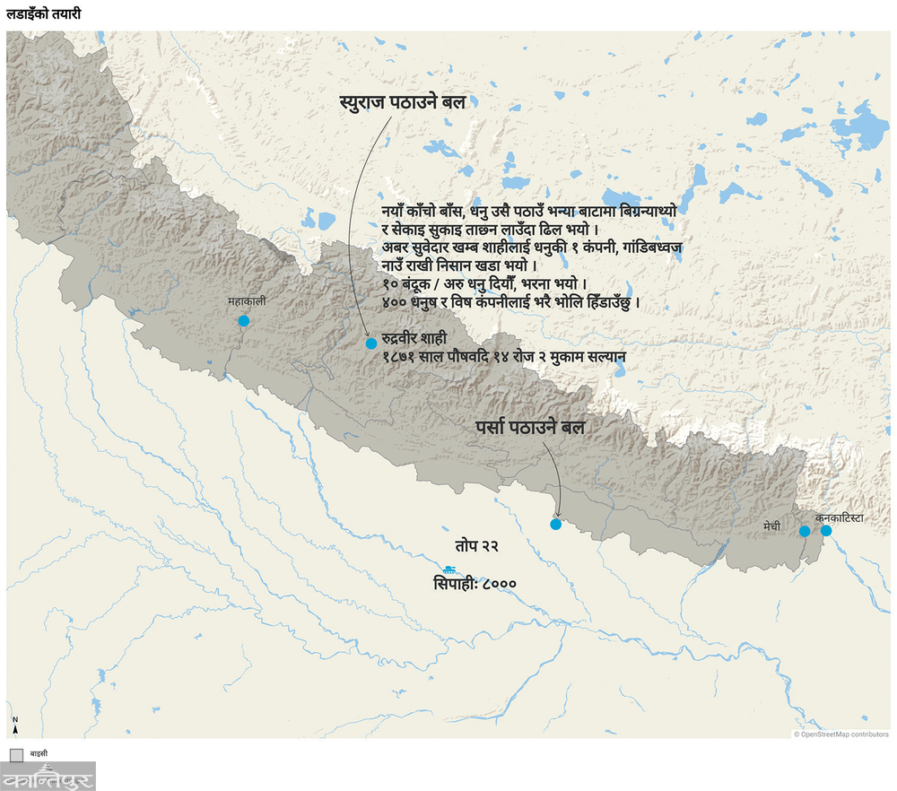
Butwal fought for 10 years. In 1871, Hindustan established its outpost at Butwal. In May, the Nepalese attacked that post, killing 18 Hindustani soldiers. After that, both Nepal and the British started preparing for battle.
The force between these two was unequal. He also prepared for battle in an uneven manner. Let's see an example of both. The land dispute between the two places became the reason for the war, one of them, Suraj, became the star of the British. So when the battle was going on, the king asked Rudravir Shahi, who was stationed at Salyan, to make good preparations for it. Rudraveer made the raw bamboo bows by cutting the bamboo, baking it, drying it and making the bow. Raised a company equipped with bows and poison.
 vs. A place of border disputes with the British until 1871.
named it - Gandibhavaj. He gave that army 10 guns, 400 bows and poison and sent Suraj. Let's look at the preparations of the East India Company, a British company established to trade in the East. He sent an army of 8,000 men to attack Kantipur via Parsa. He was given 12 cannons and 10 howitzers, cannons capable of firing shells across the hills, and many guns.
The Nepalese also do not have cannons and guns, but this battle was basically a battle between the archers and the gunners. A
battle ensued. Nepal did not lose in six places. Nepal lost in seven/eight places. One month and 7 days after the start of the battle at Nalapani, the fort fell to the British.
Bhakti Thapa fell on 6th Baisakh in 1872 during a fierce battle in West Malaun than Nalapani. The Nepalese army lost badly. On 17 Baisakh 1872, Nepal was also defeated in Kumaon. The place where Nepali ruled for 25 years was taken away.
vs. Preparations for battle in 1871.
Several battles took place at the fort of Jhamta/Jaithak, a little east and south of Malaun. The situation of Nepalese was very weak, but the British could not capture this fort. But after Amarsingh Thapa, the commander of the despondent, underfed and unarmed soldiers, agreed to leave all the territories west of Mahakali and come to Mahakali on 14th May 1872, the Nepalese had to leave this unconquered fort as well.
Let's look at the battle of Padnahgarhi in Bardia district today to understand the condition of the Nepalese army. In May 1872, the Hindustani army arrived at Bhartapur near Padnahgarhi. His army was great. He had 7 cannons with him.
Subedar Bhaktavatsal Malla of Padanah appealed to Palpa and one other place. Palpa said, "If the enemy comes closer, report, more forces will be sent." When Bhaktavatsal did not send the news, Palpa got angry and wrote two letters asking why he did not write the letter. Padnahgarhi had already been attacked by the enemy. 14 Nepalese including Bhaktavatsal, Jamdar, Major died. The rest of the commanderless soldiers ran away.
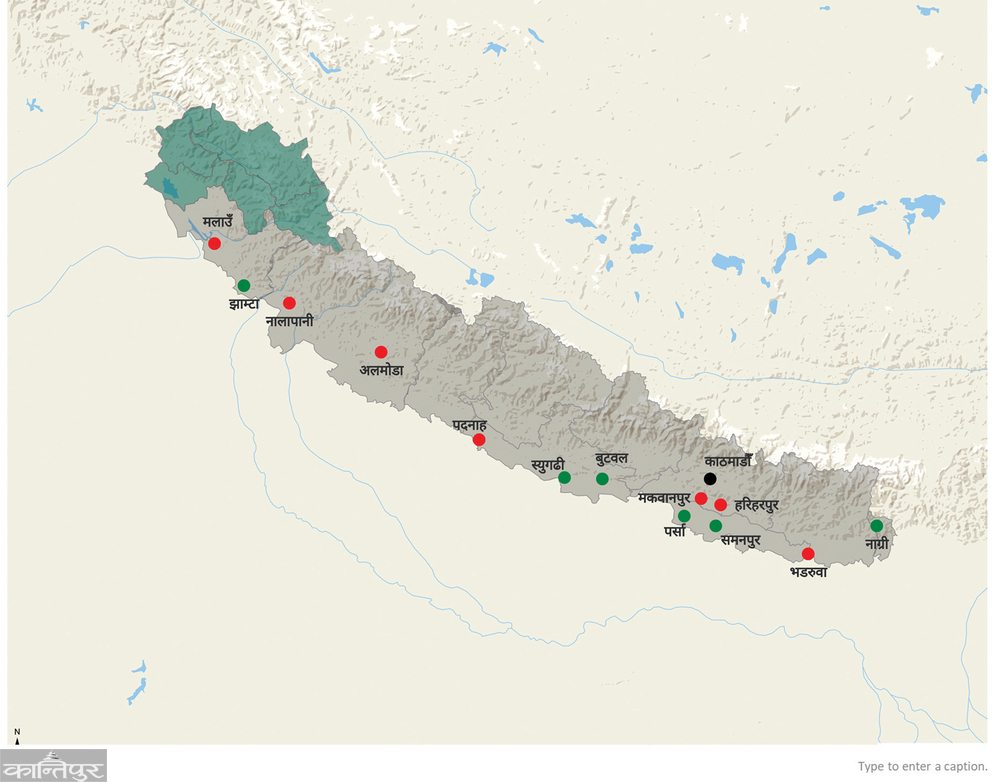
Nepal has not lost places (green) and lost places (red).
Suraj was not attacked east of Padanah. Butwal was attacked twice, both times the British lost. The British commander had been terrified ever since his first defeat. Due to this defeat of Palpa, his plan to go to Kantipur via Tansen and Gorkha was not fulfilled.
In December 1871 (the first morning of the new year of 1815), the Nepalese attacked the two forts of Parsa and Samanpur, leaving the British behind. This defeated army did not dare to look towards Nepal again.
After a long negotiation, a treaty was reached in Sugauli, India, but the king did not put the red seal on the treaty, so the British attacked again. After defeating Amarsingh in the western fort, Oktarloni came towards Parsa with a large force. At that time there was no Nepalese army in Parsa. He came to Makwanpur after capturing the Nepalese fort above present day Amlekhganj. Attacked Makwanpur.
 vs. Nepal after the Sugauli Treaty in 1872.
Nepalese suffered a great loss. Makwanpur, which Prithvi Narayan had taken away from his in-laws in August 1819, i.e. 53 years ago, Octerloni tried to take it away in February 1872. On February 21, the British defeated the Nepalese at Hariharpur Fort. The army including Kazi Ranjor Thapa, who could not be defeated by the British in Jaithak fort in the west, had to leave this fort and walk away. Because of that, the king put a red seal on the Sugauli treaty made three months ago and submitted it to the British. The fight stopped.
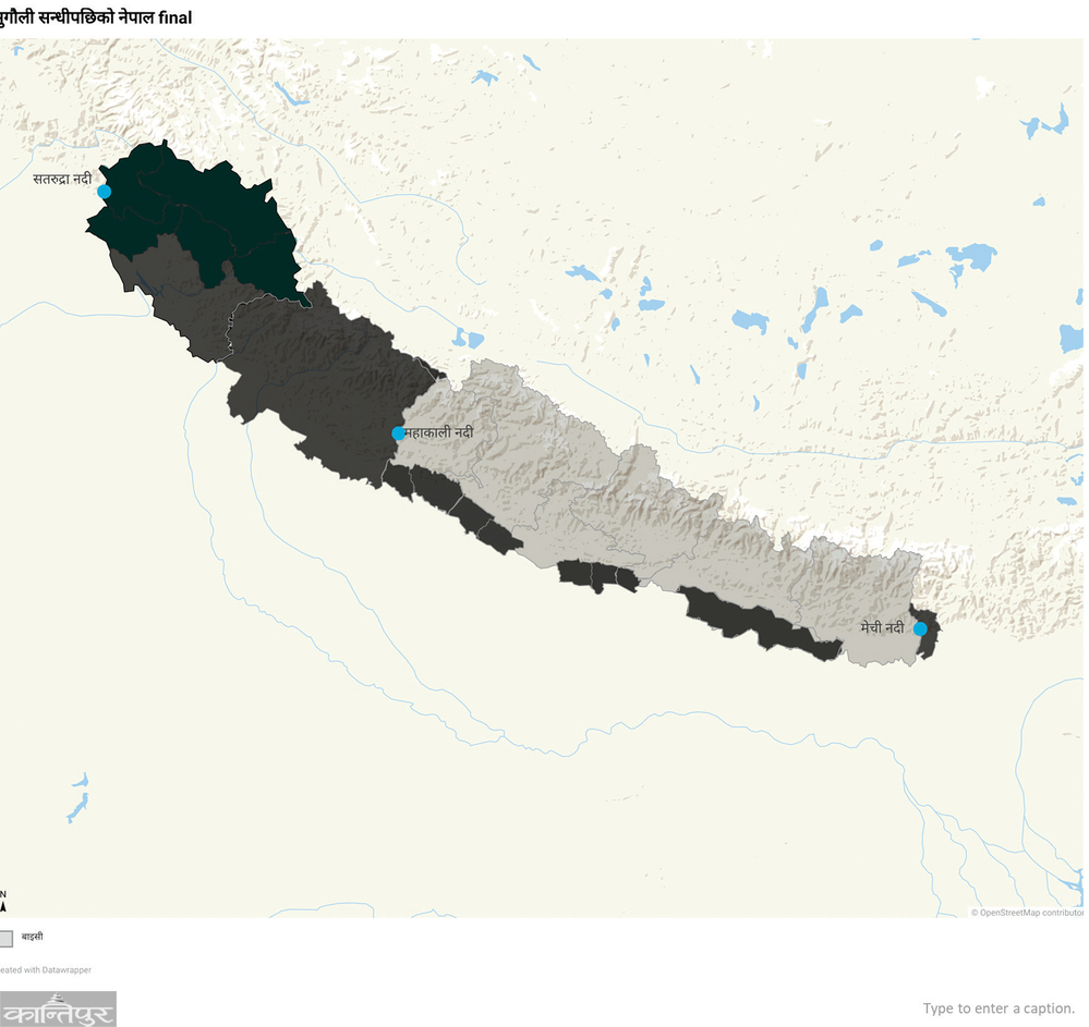
The map of Nepal has changed once again. Mahakali west, Mechi east, Koshi to Narayani, Narayani to Rapti, Rapti to Mahakali lost ground. The map extending from Tista to Sutlej was shrunk from Mechi to Mahakali. The road of Nepal spread to the east, west and south became barren. The ambition of Nepal, which is spreading like fire, was stumbled upon. After the loss of Madhesh, the income of Bhardars decreased. The Nepalese commanders were already afraid that if Madhesh was lost, the army could not be raised. Even so.
If this border is maintained, what else would have happened can only be guessed. One thing was certain - it could not be said that Buddha was born in Nepal. Nepal was originally a mountainous country without fertile plains in terms of food, wildlife and forests. The demographic, linguistic and cultural characteristics that exist in the plains of Nepal now would not have remained in this form.
A year after the fighting stopped and after getting two parts of Madhesh, the plain of Nepal spread from Mechi in the east and reached Rapti in the west. The plain west of the Rapti river was still under British possession. If this border had been maintained, there would not have been tigers and rhinoceroses in the plains west of the Rapti River. The linguistic, demographic and literary situation is as it is now, it could not have happened. That situation would have been similar to the situation across the border.
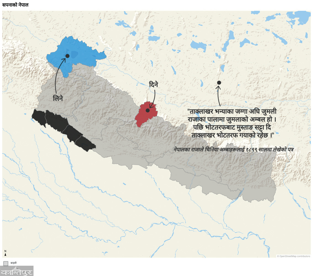
It may not be because the land of the far western plains was not returned, but there must be some other reason why Nepal dreamed of changing the border to the north. That is - leaving Mustang and taking Kailash Mansarovar.
 vs. Nepal after 1873.
In the year 1899, the king of Nepal wrote a letter to the Chinese Amwa, who were watching the Tibetan government as a Chinese representative, and said, 'Take the Mustang, give the place where Kailash Mansarovar was'. For this he argued by grasping history. He said - 'Before the land of Taklakhar (ie the settlement near Kailash-Mansarovar, which is called Taklakot today) was the Amval of Jumla during the time of Jumli Raja. Later, the Mustang went to Taklakhar instead of Votaraf.'
What would happen if this happened?
In October and October of 2081, one hundred and forty-four thousand Nepalese Mustangs arrived. If the dream of the king of Nepal 182 years ago had been fulfilled, so many Nepali Mustangs would not have arrived. They would not get to experience the unique and exciting landscape across the Himalayas. Their unique cultural heritage would not be ours. However, there would have been another advantage - Nepalis would not have to work as hard as they do now to get permission to go to Mansarovar.
A few years ago, Indian Prime Minister Narendra Modi was visited by Nepal at Muktinath. If the king's dream had been fulfilled, Nepal would not have been able to do this. Instead of Muktinath, he was found to rock Kailash Mansarovar! Had that been the case, he would have been more happy because Kailash is considered a greater Dham than Muktinath. If this dream had come true, Nepalgunj would have turned upside down. Nepalgunj could have benefited more than it does now as a gateway for Indian pilgrims going to Kailash Mansarovar.
But, that sweet dream turned into a dream.
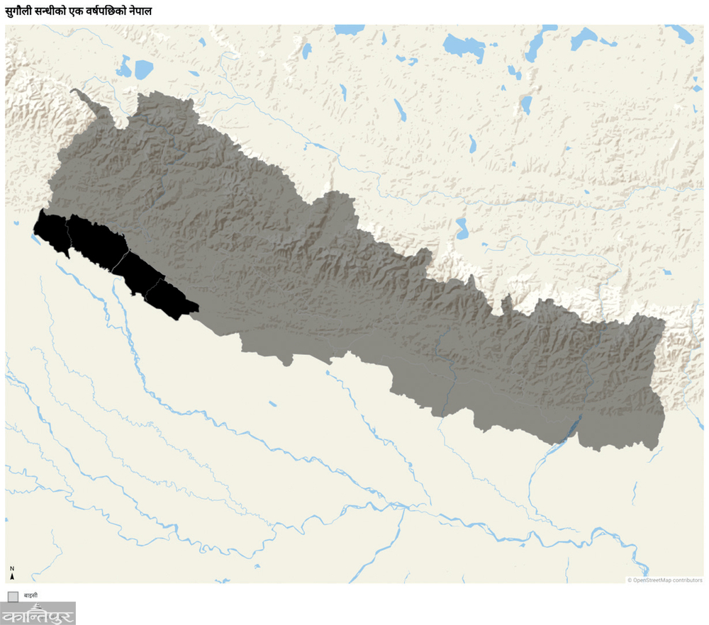
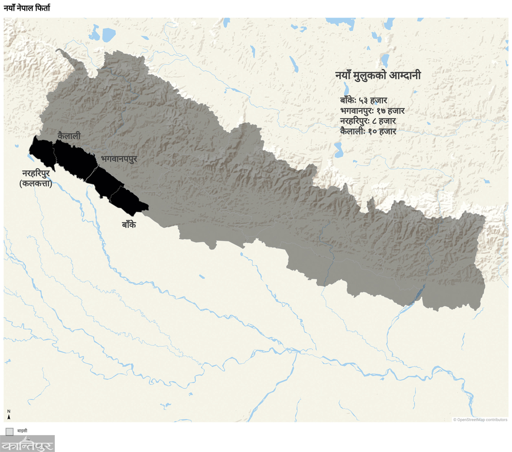
After 18 years, at the end of October or beginning of November 1917, Nepal got the new country back. Four districts of the new country – Banke, Bardia, Kailali and Kanchanpur.
 vs. Nepal wanted by Nepal in 1899.
Ah Ah No No. Not Banke, Bardia, Kailali and Kanchanpur. Banke, Bhagwanpur, Kailali and Naraharipur. That was his name then. Nepal got 17 tappas of those districts, where there was about 290,000 bighas of land. At that time, the annual income was around 90,000 baht. After deducting the expenses, more than 74 thousand Bharu reached Maharaj's pocket. The most land was in Awadi Banke. The income was also high from here.
In the Nepal-British war, it seems that only one place in the new country was fought in Padnahgarhi. Despite the defeat there, Nepal got this place back because Nepal defeated the rebels in Lucknow.
 New Nepal returned to the time of Jung Bahadur.
Then in the year 2018, the map of the northern part of Nepal changed a little. 1836 square kilometers of Nepal went to China. 2139 square kilometers of China came to Nepal. After this, a tip was added to the west by Nepal, where India rules. In this way, the map of Nepal almost came to its current form.
(Note: In some maps used here, the borders may be slightly shifted. So please understand them as indications only.)