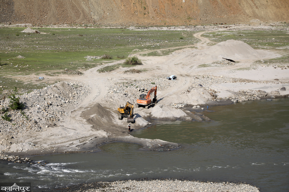
Excessive mining of riverine resources in the Chure region, increasing human activities, and other factors have weakened the natural system of water absorption in the ground, which is increasing the water crisis from Chure to Bhawar in the south.
We use Google Cloud Translation Services. Google requires we provide the following disclaimer relating to use of this service:
This service may contain translations powered by Google. Google disclaims all warranties related to the translations, expressed or implied, including any warranties of accuracy, reliability, and any implied warranties of merchantability, fitness for a particular purpose, and noninfringement.
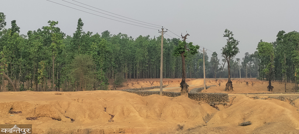
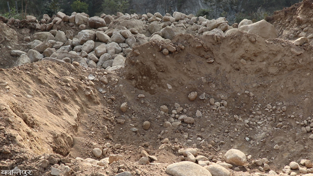
In the Chure region, which is important for water supply for the Terai, the flat fertile land has started turning into a 'desert' with destruction. The risk of groundwater depletion is increasing due to increasing soil erosion, landslides and excessive mining of riverine materials (sand, gravel) in the Chure region. According to the Research Summary 2023 published by the President's Chure-Terai Madhesh Conservation Development Committee, the weak soil structure and human activities in the Chure region have weakened the natural system of water absorption in the ground, which is increasing the water crisis from Chure-Bhavar to the south.
Low rainfall, heavy rainfall at once (which prevents water from reaching the ground), exploitation of the Chure region and rapid settlement development in the foothills of the Chure have stopped water storage in the ground. Last year, there was a drinking water crisis in Madhesh regions like Birgunj and Janakpur in Asad. The government of the then Prime Minister KP Sharma Oli had declared Madhesh Province a disaster-stricken area on 7th Shrawan of last year after a long drought.
Most people in the Terai-Madhesh region depend on taps for drinking water. As traditional wells and wells have become useless, taps have also dried up, making Madhesh a desert. According to the committee's geologist Premnath Poudel, as the groundwater level has decreased, water has stopped coming from most of the hand pumps (tubewells) in the Terai. Farmers who irrigate using medium and deep boring have started facing problems. 'Last year, there was a water shortage in many districts of the Terai. The Chure should be recharged for water to come to the Terai. Currently, the Chure is being recharged less. It seems that the water problem will increase in the coming days,' he said.
The Chure range, known as the youngest mountain range, is also called 'Siwalik'. The Chure range covers an area of 800 kilometers in 37 districts from east Ilam to west Kanchanpur. 12.78 percent of the country's total land area falls in the Chure region. The Daunne River in Lumbini extends from Bardaghat in the west to Chisapani Bridge in Bardiya. The north-south width is 10 to 50 kilometers depending on the hill. Geologist Poudel says that the destruction and exploitation of the low hills, flat plains, gorges and dunes in the south, which are visible from the Terai to the north, are increasing as the Chure region is not protected. Also known as Bhawar, the area is facing increasing water crisis due to the expansion of roads and cities as well as unorganized excavation.
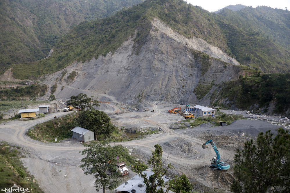
Environmentalist Vijay Singh Danuwar says that the water source is drying up due to the destruction of Chure due to the rehabilitation program brought to the Terai along with the eradication of malaria, deforestation during the construction of the East-West Highway, the crusher industry and the random operation of dozers. According to the President's Chure-Terai Madhesh Conservation Program, the random limestone excavation has also increased soil erosion in the Chure hills. The concrete buildings and blacktop roads built during the settlement development process have mixed the water flowing from the Chure into the river. As a result, the water flows straight away, and the land is not irrigated. ‘This has brought about two kinds of crisis. One is that the water has not been recharged. On the other hand, the increased flow of water in the river has caused floods and landslides,’ said Danuwar.
Earlier, when the Chure area was green, water could be found underground after burying 20/25 feet of pipes. Now, those living in the foothills of the Chure have experienced that it has reached 110 feet. Arjun Upadhyay of Tilottama-6, Rupandehi, said that as the greenery in the Chure has decreased, the water sources have started drying up. ‘The water has not been recharged after the source dried up due to erosion and slope in the Chure,’ he said. ‘The Terai has been pushed towards the desert.’ He said that after earlier 30-foot pipes were buried, today they have to be buried at least 70 feet for the water to come.
Senior hydrogeologist Namraj Bhattarai of the Groundwater Resources and Irrigation Development Division Office, Dang, said that the destruction of the Chure region and the plotting of cultivable land have affected the groundwater. ‘Until 10 years ago, the water flowing from the Chure region used to spread over thousands of bighas of land at the bottom. It used to rain for weeks. The water used to accumulate at the surface of the ground,’ he said, ‘But, now there is neither forest to recharge the Chure, nor flat land at its bottom. After all the concrete houses covered the land, how can the water flowing down reach the river directly through the drains and channels?’
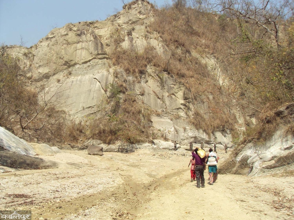
According to him, the most problems are now being seen in the cultivable lands of the Terai districts including Rupandehi, Kapilvastu, Dang. The Chure range itself is an area made up of loose, uncultivated rock. Even small amounts of water cut through the rock. The soil flows away. Therefore, it is considered very sensitive in nature.
Environmental researcher Yubaraj Kandel said that if the sensitivity of Chure is not understood in time, it will lead to a major humanitarian disaster. He said that trees should be planted in Chure to prevent rock cutting and soil erosion, and that existing trees should be protected.
Accumulating silt, rivers drying up
There used to be 24-hour water in the area about 100 meters northwest of Dudhaura Bridge in Bara. Durga Waiwa of Piluwa in Bara said that wild animals used to come to drink water. ‘Nowadays, there is no water in the Dudhaura River as the source of Chure has started drying up,’ Waiwa said, ‘Until a decade ago, water used to flow throughout the year. Now, nothing but sand is visible.’
The rivers/streams that used to flow throughout the year along the East-West Highway have now turned into mounds of sand and silt. The existence of such rivers/streams is in danger after their roots dried up due to increasing encroachment, uncontrolled stone and gravel excavation and deforestation in Chure. There are about a hundred small and large rivers from Saptari to Bara.
Rivers that did not decrease in water flow until a decade ago are now completely dry. Water does not flow in the Dudhaura, Pasaha, Bakaiya rivers of Bara and Dhansar, Chadi and Paurai rivers of Rautahat that originate from the Chure. Rivers like Kamala of Dhanusha, Ghurmi Khola of Siraha and Bataha have started drying up in the last decade.
Water flows in these rivers only when it rains in the head of Chure. Dr. Shaligram Upadhyay of Chandranigahapur said that the problem is that the state is not paying attention to the protection of the Chure region. 'The day has come when we have to see the rivers that never dry up drying up. The only major reason for this is the ruthless excavation carried out on the chest of the Chure,' he said, 'running a dozer on the Chure means squeezing the neck of the Terai.'
The mainstay of the Terai is agriculture. 70-year-old farmer Butu Mahato of Vrindavan Municipality-1, Rautahat, said that the fields have become barren due to the lack of water from the pump and the lack of water in the river. 'When we rely on sky water, we could not sow the fields on time. When we rely on boring, the ground dries up and no water comes,' he said, adding that last year, rice production decreased.'
The government has been spending a large amount of money every year for the conservation of the Chure through the 'President's Chure Conservation Program'. The government started this program from the fiscal year 2066/67. Sharad Babu Pangeni, Information Officer of the President Chure-Terai Madhesh Conservation Development Committee, Khumaltar, informed that a budget of Rs 251.9 million has been allocated for the conservation of Chure in 8 districts of Madhesh Province in the fiscal year 2080/081, Rs 30 code 46 in 081/082 and Rs 249 million for the current fiscal year. According to Information Officer Pangeni, the budget is being spent on works such as controlling gullies and gullies in the upper reaches of Chure, promoting greenery, creating reservoirs, constructing lakes, planting trees, and protecting the river and source of Chure. However, activists have been protesting, saying that there has been no achievement despite spending so much budget.
The problem after the source itself dried up
The source of the Chure region has started drying up, causing a shortage of water for wildlife. There is a shortage of water from Falgun to Jestha. Geologist Poudel said that although it seems that the drying up of the water source in Chure is only a problem for humans, it has also affected the environment. "We only look at it from a human perspective, but it has affected aquatic and terrestrial animals. Water sources and ponds have dried up. In the dry season, all these animals are troubled by water," he said. For this, Poudel says that recharge ponds are being built in collaboration with the local level, provincial government and federal government.
He says that when lakes and ponds dry up, the land becomes dry and there is a risk of major fires in Chait, Baisakh and Jestha. He said that in the last few years, fires have been burning for a long time in the Chure forest. "The lakes with water keep the surrounding area moist. Due to which it is humid even in the dry season. But when lakes and ponds dry up, the fires increase," he said.
‘Due to erosion and landslides, water sources in the Chure region have been buried, some have dried up,’ said Karan Bhatta, program coordinator of the Chure Conservation Network in Kanchanpur. ‘The streams and drains are also drying up.’ According to him, for the past few years, water has been drying up in the Khanya and Kamikate rivers in the district during winter. There is a shortage of water due to lack of protection of the springs. He said that the springs have also started drying up due to the annual fires. ‘The recharge of water in Chure is decreasing,’ said Laxmiraj Joshi, head of the Division Forest Office, Kanchanpur. ‘With the impact of climate change, rainfall has become irregular, heavy rains occur at once and this leads to floods and landslides.
According to him, rainfall is very low in winter, and there is a lot of rain in a short period of time during the monsoon, so the springs are now drying up because the ground is unable to absorb water. Joshi says that the Division Forest is preparing to construct artificial ponds along with protecting the water sources. According to him, due to the lack of water not only in Chure but also in the forests of the Lavladi Mohana protected area, the Division Forest Office has made a plan to build artificial ponds in the area. There were twelve lakes in Bahrakunda in the Rautela area of Chure. All the lakes used to be full of water. Now, only two have water. 'There are many springs in Chure, but there is a lack of protection, and they need to be repaired,' said Ravindra Kunwar, president of the Chure Conservation Network. 'We have also built some ponds for wildlife by bringing water from the springs.' According to him, 8 ponds and lakes have been built in the Chure area.
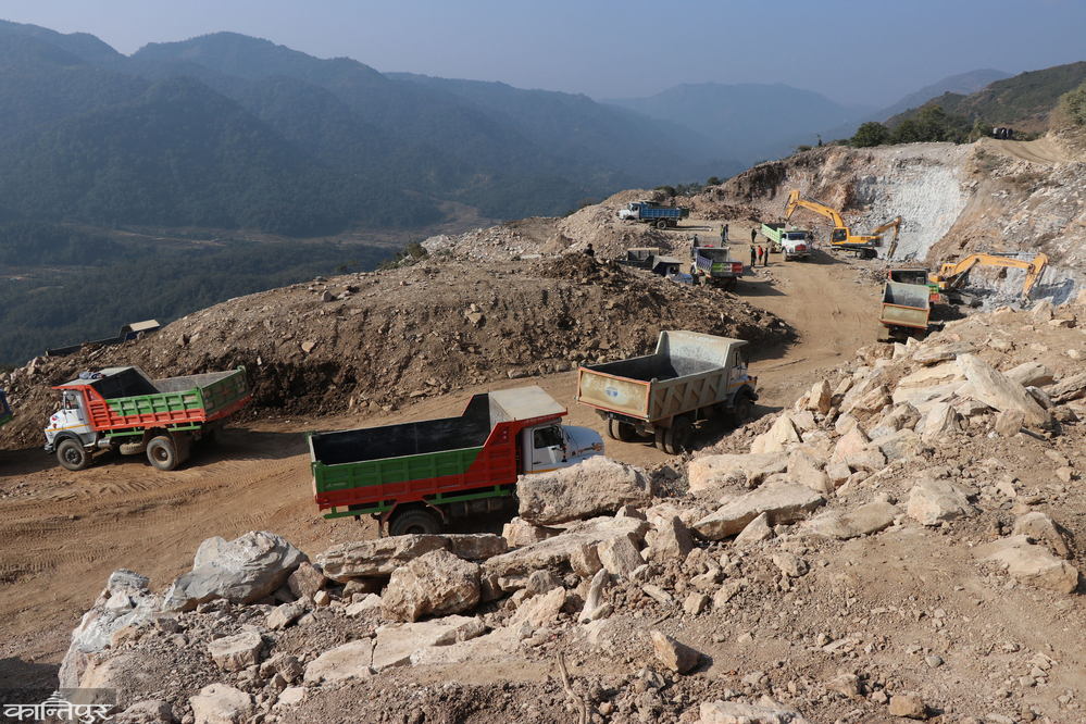
There is a double crisis in Chure of Jhapa-Ilam at the moment. On the one hand, illegal mining of river-borne products is rampant. On the other hand, the locals are directly affected by it. The springs in the area are drying up due to the extreme exploitation of Chure. Despite the legal ban on mining river resources in the Chure area connecting Rong Rural Municipality of Ilam and Mechinagar of Jhapa, extensive exploitation of stones, gravel and sand is taking place. According to locals, this illegal activity, which has been going on for years, has deepened the river. The forest is being destroyed. Which is disrupting the entire environmental balance.
Its impact is starting to be directly seen in the settlements of the Chure area. The roots have dried up in Golatar of Mechinagar-3. Local Harka Bahadur Darji says, ‘The village has been facing a water crisis for a long time.’ Post-earthquake geological changes, use of dozers during road construction in the Chure area, deforestation and excessive mining seem to have created obstacles in the natural cycle of water. The rivers that used to flow throughout the year now dry up completely after the onset of winter.
Water crisis is also starting to be seen in the villages connected to the Chure area around Bahundangi-1 and Patapur of Rong-6 of Ilam. Chure expert Dr. According to Vijay Kumar Singh, the structure of the Chure region is such that the stones, sand and gravel there absorb and store water. However, when these materials are extracted uncontrollably, the water holding capacity of the ground decreases. Although the government has declared the Chure region a conservation area, the implementation seems weak. Locals allege that illegal activities are taking place widely outside the excavations permitted only in limited areas. Experts say that the problem is further complicated by the lack of coordination between local levels, weak monitoring and lack of political will.
Arjundhara Municipality Mayor Baldev Gomden accepts the locals' allegations. 'It does not seem possible to stop the exploitation of Chure through the efforts of the local government alone,' he says, 'The readiness of the locals is necessary.' According to the President's Chure-Terai Madhesh Conservation Development Committee, about 20-25 percent of the total area of Jhapa falls under Chure. Jhapa's area is 1,606 square kilometers. According to the 2078 BS census, the total population of Jhapa has reached 994,090. A large part of them seem to have started settling in sensitive areas near Chure. Especially in the northern wards of Damak Municipality, Shivasatakshi Municipality, Mechinagar, Arjundhara and Buddhashanti Rural Municipality, thousands of households are spread within the Chure area. In Jhapa, about 39,154 households are in the Chure area. On which 169,909 people are dependent.
Devi Lake in crisis
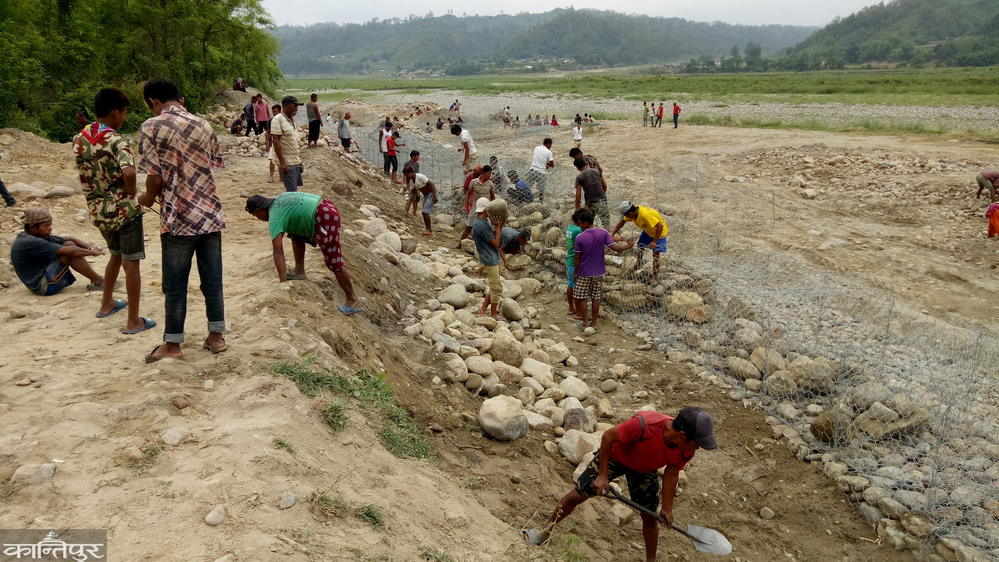
Devi Lake is located within the Chitwan National Park, right next to Chure. The challenge of protecting this large lake of the park has increased. Chure's Gegran comes and accumulates in the lake. In addition, the lake is covered with Michaha species of weeds. The water is low. It is difficult to distinguish whether it is a lake or a meadow. Hemraj Acharya, Conservation Officer of the Planning Branch of the National Park, said that along with Gegran, two creeks on the eastern and western borders also fill with sand. The area of the lake is about 42 hectares. Currently, water is visible only in five hectares.
‘This is a very important lake in the western part of the park where rhinos play and other animals drink water. It has been getting filled up even though it has been cleaned from time to time since 20-22 years ago,’ said Kamal Jung Kunwar, former chief conservation officer of Chitwan National Park. Park officials say that there has been a lack of budget to clean the lake. Senior conservation officer Ganesh Pant, who is also the chief of Chitwan National Park, said that this time the lake was cleaned by spending 998 thousand rupees. Last year, there was no budget to clean the lake.
‘In addition to cleaning, the creeks on its eastern and western borders have caused problems. If a better dam had been built in those creeks, this lake could have been saved,’ said Pant. According to geologist Poudel, not only in Chitwan but also in the Chure, small and large lakes are drying up. He claimed that the committee is working to bring it back to its previous condition. Bhavani Bhatt (Kanchanpur), Ghanshyam Gautam (Butwal), Shiv Puri (Rautahat), Parvan Portel (Biratnagar) and Ramesh Kumar Poudel (Chitwan)
