The evacuees are in the houses of the locals in the surrounding villages and in the community building
We use Google Cloud Translation Services. Google requires we provide the following disclaimer relating to use of this service:
This service may contain translations powered by Google. Google disclaims all warranties related to the translations, expressed or implied, including any warranties of accuracy, reliability, and any implied warranties of merchantability, fitness for a particular purpose, and noninfringement.
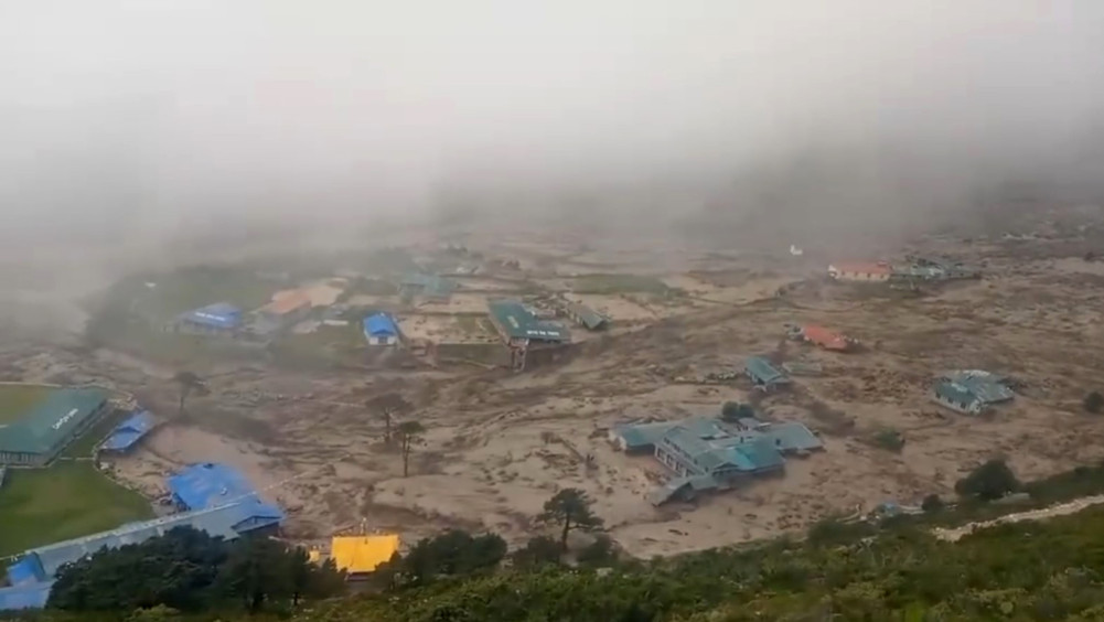
In Solukhumbu's Khumbu Pasanglhamu Rural Municipality-5, Thame on Friday afternoon, the flood washed away 20 houses, Thame Basic School and a clinic building. 55-year-old Nima Nuru Tudu Sherpa has gone missing after being hit by the Thame River flood.
There was a flash flood in the tourist village of Thame around 1:30 in the afternoon. Dwarika Prasad Ghimire, DSP of the District Police Office, said that the sudden floods in the Thame River, which flows along the border of Dolakha and Solukhumbu, have terrorized the locals. The flood has destroyed some houses and damaged some. One person is missing. As the incident happened in the afternoon, there was no major human loss," he said. When the flood came, the school was out. Some locals went to Namche, a five-hour walk away, to fill Hatia on Friday. According to the DSP official, seven houses damaged by the flood are in a state of collapse.
According to Chief District Officer Devi Khatri Pandey, as soon as they got the news about the flood, a team of police and Nepalese army from Thambuche, Namche was dispatched to the area for rescue.
DSP Ghimire said that even with the police in Thame, they could not know the details of the incident due to the lack of communication. "Neither the telephone works, nor our communication set has worked," he said.
The coastal area of Dudhkoshi has also been damaged after the flood from the Thame river. The only concrete bridge leading to the Khumbu area has been damaged due to increased water flow in Dudhkoshi. A part of the Orlanghat bridge connecting Mapyadudhkoshi and Khumbu Pasanglhamu Rural Municipality has been washed away. According to the police, vehicles cannot drive on the bridge without repairs. The bridge was built by both rural municipalities as a Miteri bridge with joint investment. The high flow of Dudhkoshi has washed away more than 200 meters of footpath in Jorasalle.
According to Lakpachiri Sherpa, spokesperson of the municipality, the population of Thame is 370. But since there is no tourist time, now more than half of the stay is in Kathmandu and other places. According to the police, 135 people, including 93 people who were stranded after the flood, eight teachers, two staff members and 32 students in the dormitory of the local school, have been shifted to a safe place. The local government has started making relief plans for the victims. "A big disaster has happened, we are making an effective relief distribution package," Mingachiri Sherpa, chairman of the rural municipality, said to Kantipur.
Anil Pokharel, executive head of National Disaster Risk Reduction and Management Authority, said that if the weather cooperated, a team would be sent from Kathmandu by helicopter to the risky place on Saturday. According to him, the team carrying relief materials will conduct a preliminary study of the affected area. "The first thing is to go with relief. The team then conducts a preliminary study to see if there is any additional risk,” he said. The local administration as well as the police have issued notices to be cautious in the lower coastal areas as the risk situation in Thame is still present.
According to the police, the flood level has decreased a bit in the evening. The water level at the flood measuring station of the Department of Water and Meteorology, which is about 82 km below Thame, suddenly rose by 1.20 meters at 5:10 pm, but within half an hour, the water level started receding. "Though there is no immediate danger in the lower coastal area than Rabuwabazar, it seems appropriate to be cautious in the riverside area of Dudhkoshi until tomorrow (Saturday) morning," the weather forecast division said.
Nothing has been revealed about how the sudden flood occurred in Thame, which is 3,800 meters above sea level. According to Sherpa, the spokesperson of Khumbu Pasanglhamu rural municipality, the flood occurred due to the bursting of the small snow lake at the head of the Thame river or the fall of a mountain. "There is a small lake at the head of Thame river, it is not certain whether it burst or the flood came after a mountain fell and blocked the river," he said. According to the Flood Forecasting Division of the Department of Water and Meteorology, 65 mm of rainfall has been recorded in the last seven days at Fortsekendra near Thame. The average daily temperature also increased (from 9.7 to 11 °C) since July 25. The average temperature on Thursday reached 15.9 degrees. "Continuous rains and temperature rise may have led to an avalanche in the area or some other reason, the ice dam in the Thame river watershed may have exploded," the department said.
Midwest University Dean Sudeep Thakuri, who has been studying glaciers and glaciers in the Everest region for decades, says that floods may have occurred after a dry landslide or an avalanche cut a river. According to his analysis, the possibility of flooding due to lake bursting in that area is low.
Thame is a Sherpa settlement on the way to Tibet. Nepal's Nangpala canal connecting China passes through this stop. One has to walk for 2 days to reach Nangpala from Thame. 30 percent of the tourists who reach Namche stay at Thame. They also stop and sit after jumping to adapt their body to the environment. Tourists also have to stop to cross Renzola, which is at a height of 5,345 meters. "Thame is full of tourists during the season," said Lamakaji Sherpa of Namche.
Most of the youth from the village of famous mountaineer Appa Sherpa are still involved in the climbing profession. Residents are also involved in potato farming and chaunripalan business. According to the locals, there was a similar flood in Thame 30 years ago. On the night of June 21, a sudden flood washed away 8 houses in Dolakha's Rolwaling river across Thame. One person was missing in the flood. Due to the flood, the dowang on the Rollwalling trail was damaged. The cause of the flood is yet to be ascertained.
(with the help of Kantipur Television correspondent Bhanubhakta Niraula from Solukhumbu)
'Snow or dry The landslide may have blocked the river and caused the flood'

Sudeep Thakuri
Dean, Faculty of Science and Technology, Midwestern University
It was heard that there was a flood in the Thame area of Khumbu Pasanglhamu Rural Municipality. It is said that the lake burst and caused the flood. That is the area where the glaciers are. But looking at the nature of the flood, it seems that the flood occurred after the dry landslide in the upper area caused the river to burst. The area is more prone to avalanches than lake bursts. Looking at the videos there, it looks like a dry landslide followed by a flood. Not sure yet. That's a very upscale area.
We have been studying glaciers and glaciers in the Everest region for decades. It has been two decades since climate change and rainfall impacts were studied in the region. Glaciers and glaciers in the Everest region appear vulnerable. Glaciers have shrunk by 15 percent compared to 60 years ago. As the glacier recedes, glaciers form in the lower regions. In some places, lakes are also forming in the glaciers. In the study conducted in 2012, 625 lakes were found there. A repeat study in 2019 showed an increase in numbers and lake area. Some lakes have increased up to 200 percent. Because of that there is always a risk in the lower areas.
There are mainly 3 valleys in the Everest region – Khumbu in the east, Bhotekoshi in the west and Gokyo in the middle. It is in Bhotekoshi valley which is flooded now. Thame is not an area with many lakes.
The largest lake there is Digchho, which burst in 1985. It caused damage to Khumbu Electricity Company in Thame area. The settlement was also damaged. Since then the size of the lake has decreased. So now it is not possible to say that the lake has broken.
Now the river may be blocked due to avalanches or landslides. There is snow piled up and piled up. Due to the rocky slopes, there is a risk of snowfall. So the river may have been cut by the snow. I have done my studies on how climate change has affected glaciers and ice caps in Nepal and Tibet region of Mt Everest. Impact on lowland areas and river channels was also my area of study. I also looked at how the glaciers and glaciers have changed. I also researched the effects of changes in temperature and climate. The snow line was found to have moved up to 180 meters. Its length also seemed to be decreasing at the rate of 6 meters per year. In the latest study conducted from 1987 to 2017 in Nepal as a whole, it was found that the number of lakes increased from 550 to 1,550. Khumbu, Tamor, Arun Valley and Gandaki have seen the highest increase in glaciers. Due to this, the risk in the lower watershed area is high.
Our geographical situation is complex. Mountains are always dangerous. At any time, the risk of floods and landslides remains high. The risk of flood should be taken into account when establishing a settlement. Above the flooded Thame area is a steep hill. Houses are built right next to the river. There are many settlements like Thame from east to west of Nepal. Therefore, the settlement should be planned from the ward. A house should be built only by thinking of ways to avoid disaster.
(based on a conversation with Sudeep Kaini)