The federal government should take the initiative for budget management through detailed studies and cost assessments: Technical Study Committee
We use Google Cloud Translation Services. Google requires we provide the following disclaimer relating to use of this service:
This service may contain translations powered by Google. Google disclaims all warranties related to the translations, expressed or implied, including any warranties of accuracy, reliability, and any implied warranties of merchantability, fitness for a particular purpose, and noninfringement.
The Technical Study Committee has suggested that the federal government take the initiative for budget management by conducting a detailed study and cost assessment of the dry landslide that occurred at Uddanda in Purvakhola Rural Municipality-4, Devinagar, the source of the Tinau River.
The technical study committee formed by the District Administration Office has given this report after the landslide that occurred at the source of the Tinau River, which also includes a coal mine, and a landslide with black mud.
According to the committee's report, the soil and rocks from the landslide will damage the settlements and agricultural land in the lower bank area of the Tinau River, so it has been suggested that a detailed study and cost assessment be prepared immediately for risk reduction and the concerned bodies should take initiatives for budget management.
A large ravine has been formed in the lower area of the landslide. If there is no possibility of the landslide taking a large size, the report states that if an embankment is built, the debris (gegran) coming from the landslide will be controlled and the damage to the lower bank area will be reduced. However, the report states that the cost of building a check dam will be high and if the landslide takes a large size and a lot of gegran flows, the structure will not be able to withstand it.
According to Robert Mahara, the coordinator of the study report committee, under the monitoring and early warning system, a monitoring team will be formed, in which local representatives will be involved in continuous monitoring and informing the vulnerable communities about the landslide situation. The committee included Subodh Guragain, Acting Chief of the Water Resources and Irrigation Development Division Office, Palpa, Engineer Aditya Dhital, Water Supply and Sanitation Office, Palpa, Senior Forest Officer of the Division Forest Office, Palpa, and Engineer Safal Chapagain, Member Secretary of the District Coordination Committee Office, Palpa.
According to the committee report, the main part of the landslide spread over a large area and is very steep. Since the landslide occurred naturally, immediate engineering measures such as construction of retaining walls or bio-engineering measures such as landslide control through planting grass, plants and vegetation are not geographically and economically feasible, so it is reasonable to let it be prevented naturally.
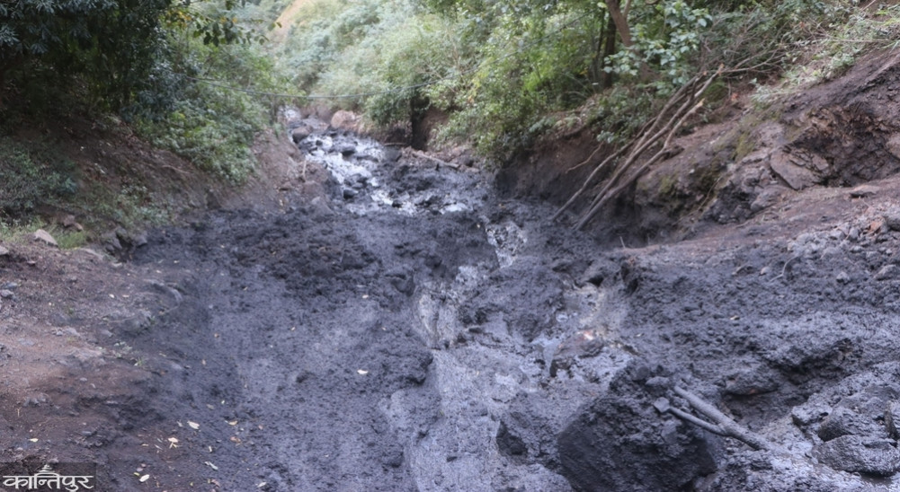
Residents of the coastal area have become panicked after black coal-laden water continuously flows from Uddanda in Purvakhola Devinagar. Although a landslide started in Uddanda four years ago, the water with coal had not flowed. In the last two months, the residents of the lower coastal area have become panicked after black coal-laden water started flowing from Uddanda into the Tinau River.
 After the news was published/broadcast by various media outlets, the attention of the Ministry of Home Affairs was drawn and the administration formed a committee to study it. The landslide here has caused black coal-laden water to continuously flow from Lindi Gaira in Uddanda, the source of the Tinau River. As a result, the residents of Mathagadhi Rural Municipality-1, Chidipani 4 Jhadeva, 3 Kaseni, Tansen Municipality-9, Baganaskali Rural Municipality-1 Chirtungdhara, 2 Ko Pokharathok, and Nairnamtaleska have become panicked.
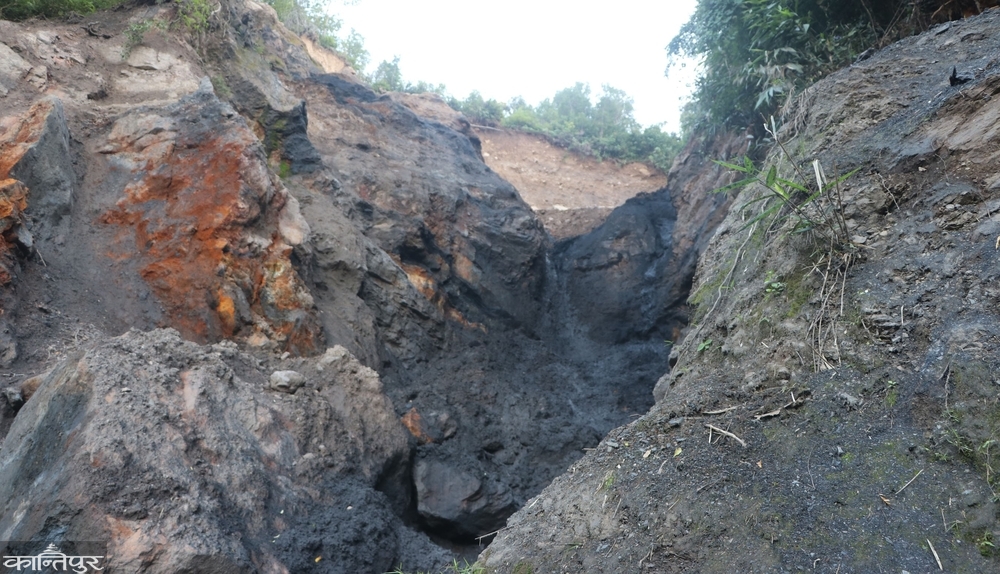
According to the committee's report, the landslide area is at an altitude of 1,150 meters above sea level. This area is in the upper coastal area of the Tinau watershed. Which is one of the many springs of Tinau. The water originates from here. The committee has also studied the land use situation by inspecting the on-site condition of the Lindigaira landslide. The landslide area is covered with forests all around. This area is especially covered with subtropical broadleaf forests of Chilaune and Katus. A rural motor road has been constructed about 15 meters south of the landslide.
The road has not been operational due to lack of maintenance. Normal settlements are visible about 200 meters west and south of the landslide. This poses a risk to 12 houses. Locals have said that this area was covered with forest before the landslide. A rural road has been constructed in the lower part of the landslide. The report states that it is not possible to go and survey the landslide area. Although the degree of steepness cannot be determined, the slope is 55 to 60 degrees with the naked eye. The report states that the area can be described as very/extremely steep since it is more than 30 percent steep.
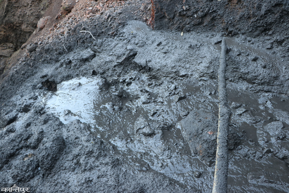
The condition of the soil in the landslide area is soft, black in color. According to the locals, there is a coal mine in the Devinagar area and coal mining was also carried out until a few years ago. Since black soil is also seen in the landslide area, it is seen as coal-mixed soil. The report states that it is necessary to conduct a lab test on whether it is coal or black soil. The water flowing from the landslide area with black mud has made the Tinau River, which flows through Madi to Butwal, black and muddy. According to environmentalists, the black mud water from coal is not suitable for livestock, farming, or drinking. There are coal mines in various places here.
 They had already received information that the previous water flowing from the coal mine was also not suitable for farming, drinking, and feeding livestock. According to environmentalist Yubaraj Kandel, the amount of carbon dioxide in the water increases. Kandel said that this then affects the growth and development of aquatic animals and plants. According to local Bir Bahadur Gaha, local residents are facing problems in bringing rice planted in the lower areas and even going to the fields. Since it is the source of the Tinau River, the residents of the lower coastal areas as well as the local residents have to face various problems due to the landslide.
Locals say that they should be aware as it is steep and there is a high possibility of landslides. The police have urged 12 households to be alert. Ward Chairman Mehar Singh Thapa said that they have been urged not to irrigate the fields, not to use water as it is the source of drinking water, and to be aware of the settlements in the upper areas. Coal was mined in Purvakhola Rural Municipality-4, Devinagar area until 6 years ago. The locals had closed it after it was extracted in a haphazard and careless manner.