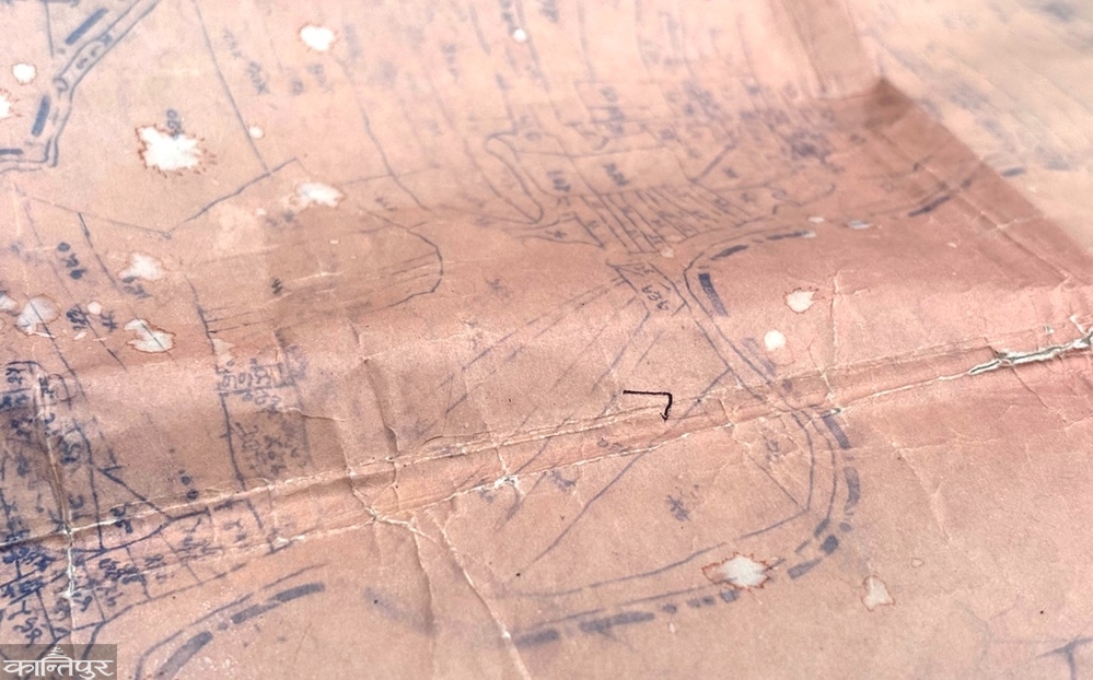
Locals complain that the Phulbasa River, which used to flow 60 feet wide according to the 2022 BS map, is now in crisis due to plotting and encroachment, which has changed its course.
We use Google Cloud Translation Services. Google requires we provide the following disclaimer relating to use of this service:
This service may contain translations powered by Google. Google disclaims all warranties related to the translations, expressed or implied, including any warranties of accuracy, reliability, and any implied warranties of merchantability, fitness for a particular purpose, and noninfringement.
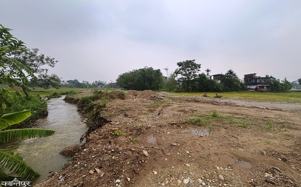
According to the map issued by the Survey Office in 2022 BS, the Phulbasa River located in Mechinagar-12 Saharedangi is a natural river flowing west-south in a curved manner with a flow area of about 60 feet wide. However, when we reach the field now, the shape shown on the map is not found. Instead, the river seems to have turned east and flowed south.
According to locals, the river was flowing in its original course until a few months ago. Recently, there have been allegations that local land developers have changed the natural course of the river and filled the old course and plotted land.
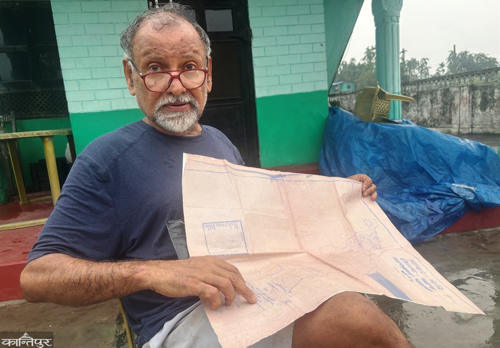
After going about two kilometers north from the Charali on the Mechi Highway and then about a hundred meters east, we reach the Phulbasa River. Local Pravin Adhikari says, ‘In the 2022 BS map, it is clearly visible that the river flows west-south with a flow area of 60 feet wide.’ Now, the river has been diverted to another direction and the old flow area has been buried.'
According to the locals, not only the natural flow area of the river, but also the public road has been cleared and the river area has been plotted. They allege that land developers have encroached on the river, public roads and natural drainage system and plotted.
The Phulbasa River is a natural waterway flowing from the north, crossing the East-West Highway and heading south. According to the old locals, this river was known as a water source that carried significant water during the rainy season. A local Pravin Adhikari had also filed a writ petition in the Ilam High Court alleging that the land of the river had been encroached upon and plotted.
Ilam High Court Judge Shyam Kumar Bishwakarma had issued a short-term interim order on 25 Baisakh 2083 not to change the natural flow of the river. However, the official alleges that even after the court order, construction and plotting activities have continued in the disputed area.
The court, based on the evidence submitted by the complainant, has also stated that the river's flow area is about 60 feet wide in the 2022 BS map. The court order states that in recent years, the river has gradually narrowed and in some places, land has been filled in and plotting activities have been carried out.
According to locals, the intervention that has changed the nature of the river has directly affected the natural drainage system. A local says, 'Where the river used to flow, plotting is now visible.'
Another important aspect of the dispute is related to the public road. According to locals, there was a public road about 16 feet wide in the area. The District Survey Office had laid the road as per the map on Chaitra 6, 2071 BS in the presence of local Sandhiyar, Bhadrabhaladami and the then VDC representative.
However, locals say that the road has now disappeared. According to them, some parts of the road have been erased, some parts have been moved into private land, and movement has been blocked in some places. A local has a question, ‘How did the public road on the map disappear? Who made it disappear?’
Locals have named former ward chairmen Narendra Dhimal, Shantakumari Limbu, and Bhakta Bahadur Limbu, accusing them of involvement in activities related to filling the river area and plotting. On the other hand, former ward chairman Dhimal has claimed that he saved the land by returning the river to its original course after the river entered his land. He has said that he did not fill the river land, but purchased 19 kaththas of land from Hari Ghimire, Hem Ghimire, and Suresh Ghimire and plotted it.
According to locals, the flow of water has been diverted elsewhere after the old stream of the Phulbasa River was blocked. Due to the change in the natural outflow route, erosion and flooding problems have started to be seen in the fields of Sandhiyar in the opposite direction. ‘The impact of the change in the natural flow of the river has started to be seen,’ says a local, ‘Now the houses and fields in the vicinity have started to be completely submerged and eroded.’
According to experts, although the immediate effect of changing the natural river flow may not be seen, its impact can be serious during the rainy season. Since water has the tendency to find its old path, artificially blocked or diverted waterways pose a risk of causing great damage in the future.
Locals have also alleged that the natural appearance of the river has been further deteriorated due to stone, gravel and sand mining and processing activities on the southern bank of the river. According to them, the river is gradually being buried due to construction materials piled up in the riverbed and human interference.
Local Pravin Adhikari had also filed a complaint with the District Administration Office, Jhapa, demanding that the Phulbasa River be returned to its original location and protected as public property. After the complaint, a team including Assistant Chief District Officer Anjan Neupane conducted an on-site monitoring. Neupane says, "It is clear that the old stream of the river has been covered with gravel, sand and soil. Now the river is flowing eastward." The District Administration Office had written to Mechinagar Municipality on April 14 for monitoring and inspection.
The municipality has formed a team including three technicians including Amin Robinson Thapa and one technician from the District Survey Office to conduct a study. The team has already submitted the report to the municipality. Amin Thapa, a member of the study team, says, ‘The river shown on the 2022 map is not found in the field now. The river appears to be flowing on private land east of the flow area on the map.’
Mechinagar Chief Gopal Chandra Budhathoki said that a letter has been sent to the District Survey Office for a survey based on the study team’s report. Budhathoki said, ‘We will move towards solving this problem after the surveyors measure it.’
Survey Office Chief Shiva Lamsal said that no letter has been received from the municipality. ‘No letter has been received for a survey,’ he said, ‘We have also sent an employee for an on-site study.’ Surveyor’s employee Vishal Limbu, a member of the study team, says, ‘There is a difference between the previous river and the current river.’
What does the law say?
The Phulbasa River dispute raises serious legal questions related to the protection of public property, natural resources, watershed areas and public roads. The Local Government Operation Act, 2074 BS has given the local level the responsibility of protecting and removing encroachments on rivers, streams, canals, culverts, public roads and public land. According to the Land Act, 2021, private encroachment on public and government land is prohibited. The Water Resources Act, 2049 BS, prohibits unauthorized interference with natural water flows and causing harm to others.
Similarly, Article 30 of the Constitution of Nepal ensures the right to a clean and healthy environment and gives the state the responsibility to protect natural resources and the environment. ‘If it is proven that a public river area has been used for private purposes or the flow of the river has been changed, there is a legal provision for the concerned body to remove encroachments, prevent damage and take action as per the law,’ says advocate Naresh Khati.