As it has become popular as an attractive destination, the arrival of domestic and foreign tourists has increased here. As you enter Langtang village by turning Mane, you will find stone-paved goretas and alleys. The hotels here are also very clean.
We use Google Cloud Translation Services. Google requires we provide the following disclaimer relating to use of this service:
This service may contain translations powered by Google. Google disclaims all warranties related to the translations, expressed or implied, including any warranties of accuracy, reliability, and any implied warranties of merchantability, fitness for a particular purpose, and noninfringement.
As beautiful and picturesque as Langtang is for trekkers, it is equally as difficult for the locals living there. The villages here are almost empty as the cold weather sets in. Due to the lack of roads, the daily lives of the residents here are forced to be inconvenienced and expensive.
After two days of walking by carrying mules and chaunri, food is not expensive. From Kiangjin Gompa to Bambu, the local health care center in Syafrubansi has survived.
Also, Langtang is a famous trekking destination. This trail is within the Langtang region, Nepal's first Himalayan National Park. Langtang footpath is located in Gosainkunda rural municipality in Rasuwa district of Bagmati province. This rural municipality has been named after the famous religious place of Gosainkunda by integrating Dhunche, Syafru, Uggurum, Thuman, Timure and Langtang VDCs.
Along with Langtang Valley and Canjing Gompa, one can also reach and observe attractive destinations such as Ganjola Pass, Gosaikund, Jugal Himal, Dorjelakpa Himal, Helambu, Shermathang, Melamchighyang, Tarkeghyang, Panchpokhri, Amayangri, Khyangphedi, Dupcheswar Mahadev Temple. Comparatively, the Langtang trail is smooth and easy compared to the trails with other names. The starting point of this trail is Syafrubansi, which is close to the capital Kathmandu. After a journey of about 100 km from Kathmandu, Syafrabensi is reached in 5 to 6 hours.
After passing through Tokha Bazar in Kathmandu, passing through Gurje Bhanjyang, Thansin, Chhare, Bidur, before entering Dhunche, the headquarters of Rasuwa district, there is a place called Ramche. Ramche's landslide used to always trouble Rasuwa district. A very sad story is associated with Ramche's landslide. Now Ramche has changed. A dirt road has been built on the landslide-prone mountain. Before entering Dhunche, there is a check post of the Nepalese army assigned to protect the national park. As it is a park area, such check posts have been placed to prevent wildlife poaching and export. It is mandatory to check your bags here.
There is a paid parking arrangement for parking private vehicles in Syafrubansi. After about three hours of walking from Syafru, there is a place called Bambu. This small settlement on the banks of the Langtang River is the first resting place after leaving Syafru. There are tea shops and some hotels in Bambu. Before reaching here, you can see large beehives. Small villages are not unheard of on the road. Most of the trekkers stay at the Lama Hotel after proceeding from the bamboo, watching the rapids of the Langtang river and many fascinating natures. Don't be fooled, Lama Hotel is the name of the place. There are many hotels in Lama Hotel, which is 2,420 meters above sea level.
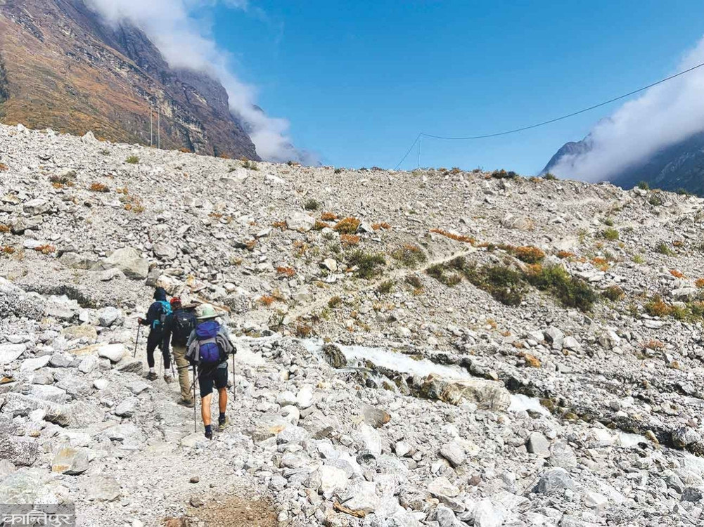
Sometimes along the Langtang river, sometimes across, sometimes the forest, sometimes the forest, sometimes the small creek. This is how the journey proceeds. Since it is a park area, before entering Langtang, you have to enter the Ghotabela range post. After about four hours of uphill and downhill from the Lama Hotel, Ghotabela is reached. Most trekkers who leave after breakfast at the Lama Hotel take their lunch break here. Before reaching Ghotabela, after the village called Chunama was cut off, the network of Nepal Telecom started working. Otherwise, since Syafru leaves the communication link is broken.
After moving on from Ghodabela, the next village you will come to is Thangsap. Villages like Thangsap, Gumba, Chamki with few houses are found along the Langtang trail. After proceeding from Thangsap and reaching a place called Chamki, Langtang village is visible.
There are many sea buckthorn weeds along the Langtang trail. The small orange fruits fascinate hikers. Locals have been walking around eating these fruits that grow along the road. We also picked some seeds from the plant and tasted them. The juice of this fruit is found in every hotel and tea shop in Langtang area. One liter costs about three thousand. Some farmers have also developed commercial cultivation of sea buckthorn.
Before entering Langtang village, one has to cross a very big landslide. The reality of that landslide is very unpleasant. Before the earthquake of 2072, Langtang village was located in this landslide place. Due to the earthquake, the avalanche that fell from about one kilometer above completely destroyed the beautiful and vibrant village of Langtang. About 300 people were buried in the avalanche because they were not exposed to fire. Some flowed. Natives, foreigners, locals, tourists, army, police, animals all fell in the landslide. In memory of the soldiers of the Nepalese army who were swept away by the landslide, the army has built a memorial pillar near the landslide. Locals and the government have not made anything in memory of the dead of the Langtang landslide. After crossing the landslide, she reached the new Langtang village.
As you enter New Langtang village, you will find cobbled streets and alleys. Langtang Village is clean and beautiful. The hotels here are also very clean. A comfortable place is needed. Hotel with hot water for shower, attached toilet in rooms. It is natural for trekkers to feel happy to have access to a difficult place.
The final destination of the Langtang Trail is Qianjin Gompa. To reach there, one has to walk for about three hours from Langtang village. Kianjin Gompa at an altitude of 3,890 meters is a border village in the northeast of Rasuwa District. Qianjin Monastery here is believed to be centuries old. The earthquake of 2072 also caused a lot of damage in Qianjin. Monasteries, including the Qianjin Monastery, which were destroyed by the earthquake, have resumed operations after reconstruction. Upon entering Kianjin, hikers are greeted by towering mountain ranges. To fully enjoy the snow range visible from the Qianjin Valley, one must climb Qianjin Ri and Serco Ri peaks.
After a climb of about 500 meters from Qianjin Village, Lower Qianjin Rico Peak is reached. Kiangjin Ri has two peaks - Lower Kiangjin and Upper Kiangjin. The height of Lower Qianjin is 4,400 meters and the upper one is 4,700 meters.
The steep climb up the Qianjin Ri mountain is very challenging. After about an hour and a half walk, Lower Qianjin Ri is reached. Upper Qianjin Ri is reached after about forty-five minutes of climbing from Lower Qianjin. The view of Langtang and Kimjung mountains, Yala Peak, Dorje Lakpa, Gangchepo etc. mountains visible after reaching Upper Kianjin makes the journey of Langtang trail worthwhile and satisfying.
Another attraction of the Langtang Trail is Serco Ri. A trip to the 4,985 meter high Serco Ri mountain gives the feeling of climbing a mountain. The journey to this mountain is very challenging due to thin air, difficult rock climbing and having to trudge through the snow. Most of the hikers start their trek in Mirmire in the morning as it is very windy in the afternoon. Locals and guides advise those who want to enjoy the sunrise to wake up at 1 am. Crossing the Chaunri Khark and ascending the Serco Rico, the view of the Langtang mountain, which looks golden in the sunlight, makes the journey unforgettable.
Throughout the journey of Serco Rico, there is no place to pour, nor any source of water. The snow piles that suddenly appear while reaching the top are mind-blowing. Guides advise to bring crampons when climbing on snow. Crampons make walking in snow much easier. The view from the summit of Cerco Rico is mind blowing. Serko Ri at 4,985 meters, the Lungdar hanging there and the snow ranges spread all around including Langtang Lirung, Langtang Ri, Kimjung, Yala Peak, Dorjelakpa, Gangchepo, Kyunga Ri, Langsisa Ri. These mountain ranges are completely open when the weather is favorable.
To reach the summit of Serco Ri, you have to climb for about five and a half hours from Qianjin village. As exhilarating and exhausting as the Serco Ri climb is, the descent is just as perilous. Returning to Shikhar Chumer takes ten to eleven hours.
Despite the natural beauty, another attraction of Qianjin is the Qianjin Cheese Processing Center operated by the Dairy Development Institute. This center, which was built with the help of the Swiss government, was also destroyed in the 2072 earthquake. After the reconstruction, the cheese processing center has been operational since 075. The operation of the center has helped the farmers of this region to become independent by selling milk.
Villages across the Langtang region are not uniform in their names and elevations above sea level. This makes the hiker very confused. Langtang or Lamtang? Serco Ri or Chirkhuri? Lama Hotel 2,420 or 2,480? As it has become popular as an attractive destination for tourism, the arrival of domestic and foreign tourists has increased here. Hoteliers across the Langtang corridor who are experiencing such pressure are worthy of thanks. Otherwise, the state's investment in tourism, which is considered the main income of the country's economy, is nowhere to be seen when walking along the Langtang Path.