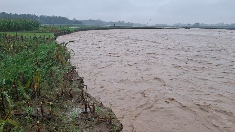
The lower coastal area of West Rapti River is always affected by floods due to steepness of the land, Gegran, Katan and Patan, river bank changes, structures built to stop the natural flow of water.
We use Google Cloud Translation Services. Google requires we provide the following disclaimer relating to use of this service:
This service may contain translations powered by Google. Google disclaims all warranties related to the translations, expressed or implied, including any warranties of accuracy, reliability, and any implied warranties of merchantability, fitness for a particular purpose, and noninfringement.
About 225 cubic meters per second of water flows annually from Nepal. There are floods in rainy season and less water resource availability in winter. Gandaki, Koshi, Karnali and Mahakali are major rivers in Nepal, while West Rapti, Kamala, Wagmati, Babai, Kankai are medium rivers.
The large rivers flowing from the Himalayan mountain range have high water levels throughout the year. They are in the form of watershed rivers with plenty of water. Mezzanine rivers have excess water during the rainy season, causing flooding, inundation, erosion and erosion. There is less flow in winter. The intermediate rivers originate from the Mahabharata mountains and enter India. On the other hand, the rivers flowing through the Chure Shivalik region are mostly river/streams of the Khare type. They flow tumultuously in the rains, in the winter there is a trickle of water.
Scientific and systematic use of Nepal's rivers/streams is essential to make the country prosperous. On the other hand, the effects of floods, landslides, inundation, erosion and landslides should be minimized and livelihoods and infrastructure should be protected. Among the five middle rivers of Nepal, Kankai flows through Jhapa, Kamala flows through Sirha and Dhanusha and Wagmati flows through Sarlahi, while Babai River enters India through Bardia and West Rapti River through Dang through Banke. Floods in the Babai River have caused extensive damage to Ghorbhita, Vanakatti, Kusumbaghat, Balapur, Guruwagaon, Jabdighat, Prayagpur, Pashuhat, Thapuwa, Ladknia and other places in Bardia district. Gulria, the headquarters of Bardia, is also at high risk from the flood of the Babai river.
The condition of the coastal region
West Rapti River originates from Rolpa and flows through Pyuthan, Arghakhanchi, Dang and Banke. This river is only 257 km long in Nepal, of which about 85 km falls in Dang. After the confluence of two tributaries Jhimruk and Madi at Airavati village in Pyuthan, it is called West Rapti. After joining Ransing river it flows almost in Shivalik region. With a catchment area of about 6,700 square kilometers, West Rapti River is joined by rivers like Lugri, Madi and Arjun Khola flowing from the Chure chain.
From the point of origin to about Dangko Bhalubang, the water flow is very steep. The catchment area mainly consists of forests, settlements, agricultural land and river flow areas. After going down from Dang's Bhalubang, the steepness of the river decreases. Small rivers like Khairi Khola, Munguwa Khola, Jhinjari Khola and Dunduwa Khola from the Chure mountain range also join the West Rapti River. This river enters India through Holia, Matehia and Gangapur in Banke.
The lower coastal area of West Rapti River is always affected by floods due to high rainfall, soil erosion, steepness of the land, Gegran, Katan and Patan, changes in river banks, structures built to stop the natural flow of water. Due to the pressure of population growth and the relatively greater availability of economic opportunities during non-flooding periods, people are migrating and even settling in flood-prone areas.
Development structures built in a haphazard manner have also become flood risk factors. Flooding has been a serious problem for the communities of the West Rapti River Basin for years. This river is fed by the Khare River originating from the Chure/Shiwalik mountain range and the Ghegran River is accumulating and rising in level. There is a problem of crop destruction and bugger formation when gegran piles up on arable land.
flood damage
This article focuses on the impact of flooding on the West Rapti River, especially in Banke District. This June 21st, 22nd and 23rd floods caused inundation in the coastal area after crossing the danger level. After that, some families from villages including Krishi Chaupheri and Border Chaupheri of Holia were shifted to safer places.
Climatic measuring center has been established in three places namely Jalkundi, Vagasoti and Kusum to measure the water level and determine the flow capacity. Due to the high water level in the rainy season, especially Bankeka Kachnapur, Mahadevpuri, Winauna, Lalpur, Dhalaiya, Shamsherganj, Vanakatti, Vethani, Kamdi, Holia, Fatehpur, Sonaphata, Zaraiya, Mataiya, Gangaparaspur, Bhagwanpur and other places are highly affected by floods.
Due to the frequent floods in the West Rapti river, the livelihood of the local residents is also facing difficulties due to the loss of wealth. Floods are seen here in 1997, 1981, 1983, 1989, 1998, 2006, 2007, 2009, 2012, 2014 and 2017. According to a study, it seems that in 1981, there was a flood that occurs once in 100 years (retnd period). The flood problem has further increased as the Kalakalua embankment built by the Indian side near the Nepal-India border has obstructed the natural drainage of water.
According to the District Disaster Preparedness and Response Plan 2079, Banke, based on the number of households and individuals affected from 2007 to 2019 and the human losses in 2017, the floods in 2014, 2017 and 2007 are the first, second and third devastating floods respectively.
The rains in 2014 seem to have done the most damage, when 15 people died and thousands were affected. Many families were displaced. At that time there was flooding for a week. The devastating flood of 2014 also changed the course of the river. Around 10 square km of arable land was eroded when the river changed. The settlement was also destroyed. About 10 years after the flood, the land there has not been used again for agriculture. Many areas still have piles of fine sand and mud.
Damage reduction measures
Gegran, erosion and erosion are important factors in the assessment of flood risk and damage, but it is rarely found that such disasters are studied and evaluated in depth. It is necessary to develop different methods based on the flow capacity by identifying the risk and estimating the damage, taking into account the integrated effects of flood, inundation, Gegran, erosion and erosion. Early warning, caution system, formal and informal information transmission system through radio, television, information exchange, disaster education, relief rescue training and management of temporary and permanent shelters should also be effective between the upper and lower coastal areas.
There are roughly three types of houses in flood-affected areas: paved, semi-paved and mud. Mud houses are more damaged. If half-paved and mud houses are constructed at least 0.5 meters above ground level, the risk can be reduced. For the protection of livelihood and infrastructure, an integrated study should be done to prepare a risk map of flood, Gegran, erosion, erosion and land use policy should be made accordingly. Flood and disaster resistant structures should also be constructed.
- Subedi is studying the risks and damages that can be caused by flooding, Gegran, erosion and erosion.