Local businessmen say that despite hundreds of tourists visiting Annapurna Base Camp daily, problems are increasing with temporary tents, communications, and waste management.
We use Google Cloud Translation Services. Google requires we provide the following disclaimer relating to use of this service:
This service may contain translations powered by Google. Google disclaims all warranties related to the translations, expressed or implied, including any warranties of accuracy, reliability, and any implied warranties of merchantability, fitness for a particular purpose, and noninfringement.
The base camp of the Annapurna Himal, which was unknown until 16 years ago, has now become a tourist attraction. The 8,091-meter-high Annapurna Himal, located in the geography of Annapurna Rural Municipality-4 of Myagdi, and the base camp from which the climb begins, have become a tourist attraction after identification, infrastructure and promotion.
After the construction of trekking routes, infrastructure, food and accommodation facilities and promotional programs, more tourists have started coming to the base camp than expected, said Bharat Kumar Pun, Chairman of Annapurna Rural Municipality. 'After the fact that the geography of Annapurna Himal and the base camp are in Myagdi and the trekking routes to reach there have been established and the promotion programs have been carried out, more tourists have started coming than the infrastructure there can support,' he said, 'Since it can be reached by trekking easily in a short time, the Annapurna Base Camp has become the choice of domestic tourists.'
Until 2067 BS, there was no information about the fact that the Annapurna Base Camp was in Myagdi. It was said that the base camp was only in Kaski. After the first climber of Annapurna, Maurice Herzog, who arrived in Narchyang, the foothills of Annapurna in 2012, informed about the route and base camp used during the climb, a team of locals led by the then principal of Prabha Secondary School, Tej Gurung, conducted research on the trekking route.
The trekking route was mapped and named 'Maurice Herzog' by the Annapurna Rural Municipality in 2077 BS. 'Based on the information and information provided by the first climber Herzog, we built wooden bridges at 68 places along the banks of the Nilgiri and Annapurna rivers and reached the base camp in seven days,' he said. 'The trekking route connecting Narchyang and the base camp, which was opened three years ago after building basic infrastructure over a period of 11 years, has become a 'virgin' destination.'
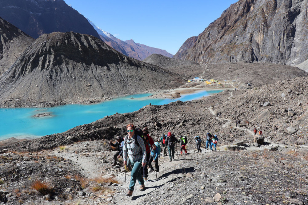
The Annapurna base camp, which is located at an altitude of 4,190 meters above sea level, is easily accessible by trekking within a short distance, making it a favorite among tourists. Michael Pun, a hotelier from Bhusket, said that the restaurant, which was set up in a temporary tent on the trekking route, had a daily capacity of 50 people, and more than 200 guests came daily in the spring and autumn.
'Since it falls under the Annapurna Conservation Area Project (ACAP), we have to complete the process and get permission from the government to build a permanent physical structure here,' he said. 'ACAP has allowed the construction of a temporary structure that can accommodate 50 guests, but since four to five times more guests have come, we have had to make arrangements for accommodation under tents and tents.'
Until three years ago, only climbers could reach the base camp by helicopter during the spring. A 20-kilometer road has been prepared from Narchang to Humkhola and a basic 22-kilometer trekking route from Humkhola to the base camp.
You can reach the base camp by observing the banks of the Mistrikhola river flowing from the foothills of the Annapurna and Nilgiri mountains, tall waterfalls, charming mountain ranges, unique geography, mountains, rare flora, and wildlife. You can reach the base camp in two days and return on the third day. The base camp is located at the foot of the Nilgiri and Annapurna Himals on a flat plain. Below the base camp is Panchkunda Lake at an altitude of 4,050 meters above sea level.
You can observe the lake and the mountains from the hill of the base camp. The lake, spread over an area of 17,684 square meters, is a natural glacial lake formed by collecting the water coming from the melting snow of the Annapurna Himal. Being able to observe the Annapurna Himal and Panchkunda Lake at the same time has become the main feature of the Annapurna Base Camp.
The base camp also has a statue of the first expedition team leader, Maurice Herzog, Louis Lachenal and Sonam Balung Sherpa, and an open museum with a copper plate listing the names of the 536 people who have climbed the Annapurna Himal so far. The lack of communication, electricity, health facilities and the low capacity of restaurants have caused problems for guests and businessmen. Due to the lack of communication, it has become difficult to rescue tourists who have fallen ill and manage the guests. With the increasing number of guests, waste management has also become another challenge here. There is a need to complete the construction of the hiking trail and upgrade the suspension bridge.